Annigeri elevation
Annigeri (Karnataka, Dharwad), India elevation is 631 meters and Annigeri elevation in feet is 2070 ft above sea level [src 1]. Annigeri is a populated place (feature code) with elevation that is 338 meters (1109 ft) bigger than average city elevation in India.
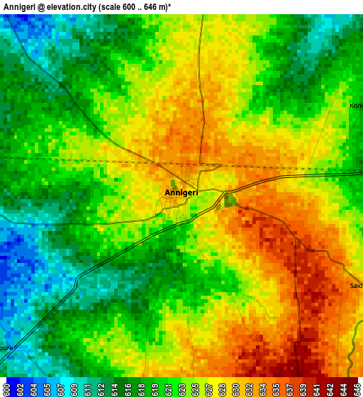
Below is the Elevation map of Annigeri, which displays elevation range with different colors. Scale of the first map is from 600 to 646 m (1969 to 2119 ft) with average elevation of 623.2 meters (=2045 ft) [note 1]
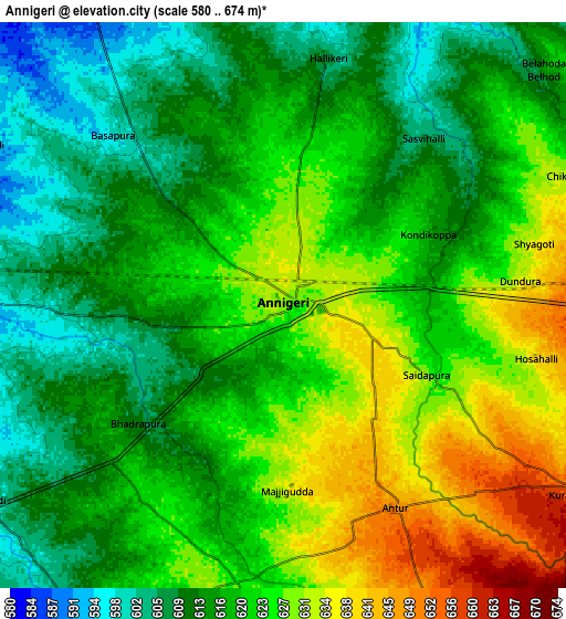
These maps also provides idea of topography and contour of this city, they are displayed at different zoom levels. More info about maps, scale and edge coordinates you can find below images.
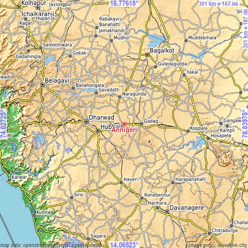
| \ | Map #1 | Map #2 | Topo.Map |
| Scale [m] | 600..646 m | 580..674 m | × |
| Scale [ft] | 1969..2119 ft | 1903..2211 ft | × |
| Average | 623.2 m = 2045 ft | 619.7 m = 2033 ft | × |
| Width | 9.42 km = 5.9 mi | 18.84 km = 11.7 mi | 301.4 km = 187.3 mi |
| Height | 9.42 km = 5.9 mi | 18.84 km = 11.7 mi | 301.5 km = 187.3 mi |
| ↑Max Latitude | 15.467488° | 15.509837° | 16.77618° |
| Latitude at center | 15.42513° | 15.42513° | 15.42513° |
| ↓Min Latitude | 15.382763° | 15.340388° | 14.06523° |
| ← Min Longitude | 75.389555° | 75.345609° | 74.02725° |
| Longitude center | 75.4335° | 75.4335° | 75.4335° |
| →Max Longitude | 75.477445° | 75.521391° | 76.83975° |
Nearby cities:
Cities around Annigeri sort by population:
• Hubli elevation 620 m
33.3 km,  255°
255°
• Gadag-Betageri 665 m
19.7 km,  92°
92°
• Gadag 655 m
21 km, 88°
• Saundatti 660 m
50.8 km,  318°
318°
• Lakshmeshwar 636 m
33.4 km,  173°
173°
• Nargund 606 m
33.5 km,  351°
351°
• Navalgund 585 m
17.2 km,  329°
329°
• Ron 581 m
44.3 km,  46°
46°
• Mulgund 687 m
18.6 km,  149°
149°
• Kundgol 645 m
27.4 km,  226°
226°
• Naregal 642 m
43.4 km,  67°
67°
• Shirhatti 681 m
26.5 km,  143°
143°
Multilingual:
 En español:
Annigeri elevación 631 m.
 En France:
Annigeri élévation 631 m.
 Auf Deutsch:
Annigeri höhe über dem Meeresspiegel ist 631 m.

Sources and notes:
- [note 1] Map square and city borders are not equal. Map elevation data is calculated only from area inside that square.
- [src 1] Elevation data from geonames database provided with same terms of usage.
- [src 2] The elevation map of Annigeri is generated using elevation data from NASA's 3 arcsec (90m) resolution SRTM data.
- [src 3] Base (background) map © OpenStreetMap contributors tiles are generated by Geofabrik and OpenTopoMap.
Copyright & License:
This Annigeri Elevation Map is licensed under CC BY-SA. You may reuse any part from this page, if you give a proper credit by linking to this URL:
 More info on terms of use page.