Barkot elevation
Barkot (Uttarakhand, Uttarkāshi), India elevation is 1291 meters and Barkot elevation in feet is 4236 ft above sea level [src 1]. Barkot is a populated place (feature code) with elevation that is 998 meters (3274 ft) bigger than average city elevation in India.
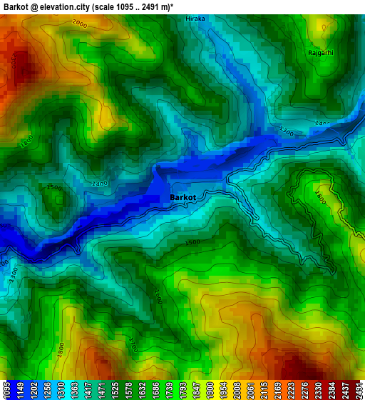
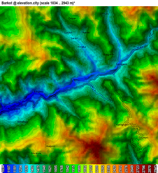
Below is the Elevation map of Barkot, which displays elevation range with different colors. Scale of the first map is from 1095 to 2491 m (3593 to 8173 ft) with average elevation of 1611.7 meters (=5288 ft) [note 1]
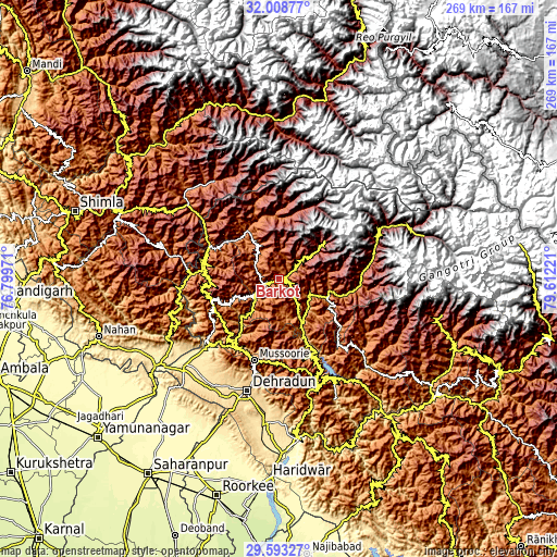
These maps also provides idea of topography and contour of this city, they are displayed at different zoom levels. More info about maps, scale and edge coordinates you can find below images.
| \ | Map #1 | Map #2 | Topo.Map |
| Scale [m] | 1095..2491 m | 1034..2943 m | × |
| Scale [ft] | 3593..8173 ft | 3392..9656 ft | × |
| Average | 1611.7 m = 5288 ft | 1829.2 m = 6001 ft | × |
| Width | 8.39 km = 5.2 mi | 16.79 km = 10.4 mi | 268.6 km = 166.9 mi |
| Height | 8.39 km = 5.2 mi | 16.79 km = 10.4 mi | 268.6 km = 166.9 mi |
| ↑Max Latitude | 30.846346° | 30.884068° | 32.00877° |
| Latitude at center | 30.80861° | 30.80861° | 30.80861° |
| ↓Min Latitude | 30.770859° | 30.733093° | 29.59327° |
| ← Min Longitude | 78.162015° | 78.118069° | 76.79971° |
| Longitude center | 78.20596° | 78.20596° | 78.20596° |
| →Max Longitude | 78.249905° | 78.293851° | 79.61221° |
Nearby cities:
Cities around Barkot sort by population:
• Dehra Dūn elevation 664 m
56.3 km,  197°
197°
• Rāipur 680 m
56.4 km,  191°
191°
• Tehri 656 m
53.4 km,  150°
150°
• Mussoorie 1824 m
41.4 km, 198°
• Clement Town 607 m
63.5 km, 197°
• Uttarkāshi 1147 m
24.3 km,  111°
111°
• Vikāsnagar 468 m
56 km,  227°
227°
• Harbatpur 448 m
60.6 km, 227°
• Rohru 1537 m
61.4 km,  315°
315°
• Chakrāta 2110 m
34.7 km,  250°
250°
• Chaupāl 2268 m
60.9 km,  284°
284°
• Jubbal 2100 m
62.6 km,  302°
302°
Multilingual:
 En español:
Barkot elevación 1291 m.
 En France:
Barkot élévation 1291 m.


Sources and notes:
- [note 1] Map square and city borders are not equal. Map elevation data is calculated only from area inside that square.
- [src 1] Elevation data from geonames database provided with same terms of usage.
- [src 2] The elevation map of Barkot is generated using elevation data from NASA's 3 arcsec (90m) resolution SRTM data.
- [src 3] Base (background) map © OpenStreetMap contributors tiles are generated by Geofabrik and OpenTopoMap.
Copyright & License:
This Barkot Elevation Map is licensed under CC BY-SA. You may reuse any part from this page, if you give a proper credit by linking to this URL:
 More info on terms of use page.