Dehra Dūn elevation
Dehra Dūn (Uttarakhand, Dehradun), India elevation is 664 meters and Dehra Dūn elevation in feet is 2178 ft above sea level [src 1]. Dehra Dūn is a seat of a first-order administrative division (feature code) with elevation that is 371 meters (1217 ft) bigger than average city elevation in India.
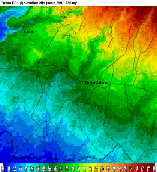
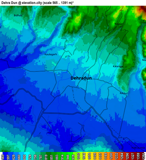
Below is the Elevation map of Dehra Dūn, which displays elevation range with different colors. Scale of the first map is from 599 to 786 m (1965 to 2579 ft) with average elevation of 666.2 meters (=2186 ft) [note 1]
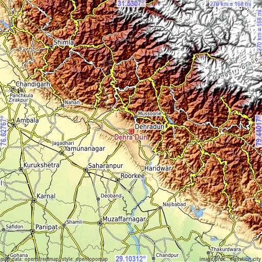
These maps also provides idea of topography and contour of this city, they are displayed at different zoom levels. More info about maps, scale and edge coordinates you can find below images.
| \ | Map #1 | Map #2 | Topo.Map |
| Scale [m] | 599..786 m | 565..1391 m | × |
| Scale [ft] | 1965..2579 ft | 1854..4564 ft | × |
| Average | 666.2 m = 2186 ft | 690.2 m = 2264 ft | × |
| Width | 8.44 km = 5.2 mi | 16.87 km = 10.5 mi | 269.9 km = 167.7 mi |
| Height | 8.44 km = 5.2 mi | 16.87 km = 10.5 mi | 269.9 km = 167.7 mi |
| ↑Max Latitude | 30.362355° | 30.400266° | 31.5307° |
| Latitude at center | 30.32443° | 30.32443° | 30.32443° |
| ↓Min Latitude | 30.28649° | 30.248535° | 29.10312° |
| ← Min Longitude | 77.989975° | 77.946029° | 76.62767° |
| Longitude center | 78.03392° | 78.03392° | 78.03392° |
| →Max Longitude | 78.077865° | 78.121811° | 79.44017° |
Nearby cities:
Cities around Dehra Dūn sort by population:
• Rishīkesh elevation 361 m
34.6 km,  134°
134°
• Rāipur 680 m
5.6 km,  105°
105°
• Mussoorie 1824 m
14.9 km,  13°
13°
• Pāonta Sāhib 403 m
41.2 km,  287°
287°
• Clement Town 607 m
7.2 km,  199°
199°
• Birbhaddar 332 m
36.9 km,  139°
139°
• Vikāsnagar 468 m
29.8 km,  302°
302°
• Chhutmalpur 298 m
42.2 km,  219°
219°
• Harbatpur 448 m
30.9 km, 294°
• Doiwāla 484 m
18.2 km,  154°
154°
• Rāīwāla Bara 320 m
38.8 km, 151°
• Narendranagar 911 m
30.3 km, 126°
Multilingual:
 En español:
Dehra Dūn elevación 664 m.
 En France:
Dehra Dūn élévation 664 m.
 Auf Deutsch:
Dehra Dūn höhe über dem Meeresspiegel ist 664 m.

Sources and notes:
- [note 1] Map square and city borders are not equal. Map elevation data is calculated only from area inside that square.
- [src 1] Elevation data from geonames database provided with same terms of usage.
- [src 2] The elevation map of Dehra Dūn is generated using elevation data from NASA's 3 arcsec (90m) resolution SRTM data.
- [src 3] Base (background) map © OpenStreetMap contributors tiles are generated by Geofabrik and OpenTopoMap.
Copyright & License:
This Dehra Dūn Elevation Map is licensed under CC BY-SA. You may reuse any part from this page, if you give a proper credit by linking to this URL:
 More info on terms of use page.