Chhutmalpur elevation
Chhutmalpur (Uttar Pradesh, Sahāranpur), India elevation is 298 meters and Chhutmalpur elevation in feet is 978 ft above sea level [src 1]. Chhutmalpur is a populated place (feature code) with elevation that is 5 meters (16 ft) bigger than average city elevation in India.
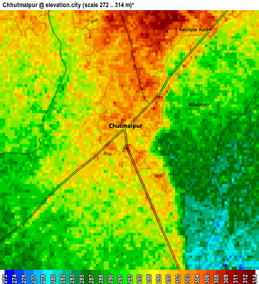
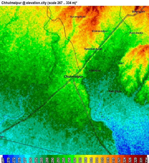
Below is the Elevation map of Chhutmalpur, which displays elevation range with different colors. Scale of the first map is from 272 to 314 m (892 to 1030 ft) with average elevation of 293.9 meters (=964 ft) [note 1]
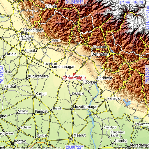
These maps also provides idea of topography and contour of this city, they are displayed at different zoom levels. More info about maps, scale and edge coordinates you can find below images.
| \ | Map #1 | Map #2 | Topo.Map |
| Scale [m] | 272..314 m | 267..334 m | × |
| Scale [ft] | 892..1030 ft | 876..1096 ft | × |
| Average | 293.9 m = 964 ft | 293.9 m = 964 ft | × |
| Width | 8.46 km = 5.3 mi | 16.92 km = 10.5 mi | 270.7 km = 168.2 mi |
| Height | 8.46 km = 5.3 mi | 16.92 km = 10.5 mi | 270.7 km = 168.2 mi |
| ↑Max Latitude | 30.070128° | 30.108152° | 31.24201° |
| Latitude at center | 30.03209° | 30.03209° | 30.03209° |
| ↓Min Latitude | 29.994037° | 29.95597° | 28.80722° |
| ← Min Longitude | 77.709345° | 77.665399° | 76.34704° |
| Longitude center | 77.75329° | 77.75329° | 77.75329° |
| →Max Longitude | 77.797235° | 77.841181° | 79.15954° |
Nearby cities:
Cities around Chhutmalpur sort by population:
• Dehra Dūn elevation 664 m
42.2 km,  39°
39°
• Sahāranpur 280 m
21.3 km,  250°
250°
• Haridwar 295 m
40.3 km,  103°
103°
• Roorkee 268 m
22.7 km,  144°
144°
• Deoband 263 m
38.1 km,  190°
190°
• Manglaur 268 m
29.4 km,  155°
155°
• Rāmpur 270 m
38.4 km,  229°
229°
• Clement Town 607 m
35.6 km, 43°
• Laksar 240 m
41.2 km, 137°
• Behat 306 m
20.5 km,  319°
319°
• Būriya 286 m
40.6 km,  290°
290°
• Doiwāla 484 m
38.5 km,  65°
65°
Multilingual:
 En español:
Chhutmalpur elevación 298 m.
 En France:
Chhutmalpur élévation 298 m.
 Auf Deutsch:
Chhutmalpur höhe über dem Meeresspiegel ist 298 m.

Sources and notes:
- [note 1] Map square and city borders are not equal. Map elevation data is calculated only from area inside that square.
- [src 1] Elevation data from geonames database provided with same terms of usage.
- [src 2] The elevation map of Chhutmalpur is generated using elevation data from NASA's 3 arcsec (90m) resolution SRTM data.
- [src 3] Base (background) map © OpenStreetMap contributors tiles are generated by Geofabrik and OpenTopoMap.
Copyright & License:
This Chhutmalpur Elevation Map is licensed under CC BY-SA. You may reuse any part from this page, if you give a proper credit by linking to this URL:
 More info on terms of use page.