Rohru elevation
Rohru (Himachal Pradesh, Shimla), India elevation is 1537 meters and Rohru elevation in feet is 5043 ft above sea level [src 1]. Rohru is a populated place (feature code) with elevation that is 1244 meters (4081 ft) bigger than average city elevation in India.
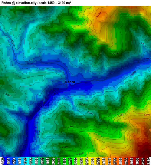
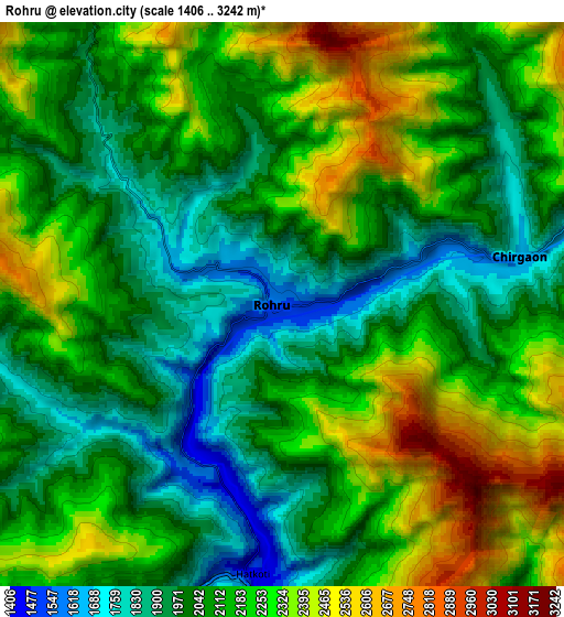
Below is the Elevation map of Rohru, which displays elevation range with different colors. Scale of the first map is from 1450 to 3190 m (4757 to 10466 ft) with average elevation of 1960.4 meters (=6432 ft) [note 1]
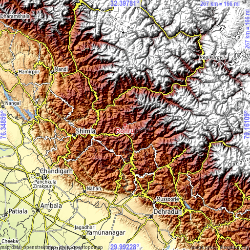
These maps also provides idea of topography and contour of this city, they are displayed at different zoom levels. More info about maps, scale and edge coordinates you can find below images.
| \ | Map #1 | Map #2 | Topo.Map |
| Scale [m] | 1450..3190 m | 1406..3242 m | × |
| Scale [ft] | 4757..10466 ft | 4613..10636 ft | × |
| Average | 1960.4 m = 6432 ft | 2137.9 m = 7014 ft | × |
| Width | 8.36 km = 5.2 mi | 16.72 km = 10.4 mi | 267.5 km = 166.2 mi |
| Height | 8.36 km = 5.2 mi | 16.72 km = 10.4 mi | 267.5 km = 166.2 mi |
| ↑Max Latitude | 31.240271° | 31.277836° | 32.39781° |
| Latitude at center | 31.20269° | 31.20269° | 31.20269° |
| ↓Min Latitude | 31.165094° | 31.127484° | 29.99228° |
| ← Min Longitude | 77.710895° | 77.666949° | 76.34859° |
| Longitude center | 77.75484° | 77.75484° | 77.75484° |
| →Max Longitude | 77.798785° | 77.842731° | 79.16109° |
Nearby cities:
Cities around Rohru sort by population:
• Shimla elevation 2073 m
57 km,  258°
258°
• Barkot 1291 m
61.4 km,  135°
135°
• Rāmpur 992 m
29.9 km,  336°
336°
• Theog 2239 m
38.8 km, 256°
• Chakrāta 2110 m
56.4 km,  169°
169°
• Rājgarh 1524 m
58.3 km,  227°
227°
• Jutogh 1785 m
61.8 km, 259°
• Chaupāl 2268 m
32.6 km,  209°
209°
• Seoni 668 m
60.2 km,  274°
274°
• Sarāhan 2161 m
34.4 km,  6°
6°
• Jubbal 2100 m
14.3 km,  223°
223°
• Kotkhai 1676 m
22.6 km,  245°
245°
Multilingual:
 En español:
Rohru elevación 1537 m.
 En France:
Rohru élévation 1537 m.


Sources and notes:
- [note 1] Map square and city borders are not equal. Map elevation data is calculated only from area inside that square.
- [src 1] Elevation data from geonames database provided with same terms of usage.
- [src 2] The elevation map of Rohru is generated using elevation data from NASA's 3 arcsec (90m) resolution SRTM data.
- [src 3] Base (background) map © OpenStreetMap contributors tiles are generated by Geofabrik and OpenTopoMap.
Copyright & License:
This Rohru Elevation Map is licensed under CC BY-SA. You may reuse any part from this page, if you give a proper credit by linking to this URL:
 More info on terms of use page.