Basi elevation
Basi (Rajasthan, Jaipur), India elevation is 361 meters and Basi elevation in feet is 1184 ft above sea level [src 1]. Basi is a populated place (feature code) with elevation that is 68 meters (223 ft) bigger than average city elevation in India.
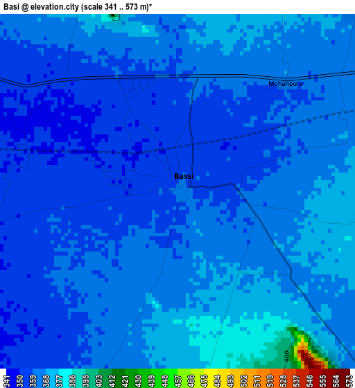
Below is the Elevation map of Basi, which displays elevation range with different colors. Scale of the first map is from 341 to 573 m (1119 to 1880 ft) with average elevation of 361.7 meters (=1187 ft) [note 1]
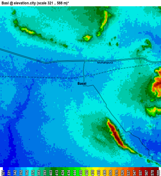
These maps also provides idea of topography and contour of this city, they are displayed at different zoom levels. More info about maps, scale and edge coordinates you can find below images.
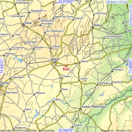
| \ | Map #1 | Map #2 | Topo.Map |
| Scale [m] | 341..573 m | 321..588 m | × |
| Scale [ft] | 1119..1880 ft | 1053..1929 ft | × |
| Average | 361.7 m = 1187 ft | 366 m = 1201 ft | × |
| Width | 8.72 km = 5.4 mi | 17.44 km = 10.8 mi | 279 km = 173.4 mi |
| Height | 8.72 km = 5.4 mi | 17.44 km = 10.8 mi | 279 km = 173.4 mi |
| ↑Max Latitude | 26.870707° | 26.909901° | 28.07933° |
| Latitude at center | 26.8315° | 26.8315° | 26.8315° |
| ↓Min Latitude | 26.792279° | 26.753045° | 25.56978° |
| ← Min Longitude | 76.004615° | 75.960669° | 74.64231° |
| Longitude center | 76.04856° | 76.04856° | 76.04856° |
| →Max Longitude | 76.092505° | 76.136451° | 77.45481° |
Nearby cities:
Cities around Basi sort by population:
• Jaipur elevation 435 m
27.7 km,  290°
290°
• Dausa 353 m
29.2 km,  77°
77°
• Niwai 347 m
53.9 km,  193°
193°
• Shāhpura 438 m
62.9 km,  351°
351°
• Chaksu 304 m
27.1 km,  201°
201°
• Lālsot 308 m
41.1 km,  137°
137°
• Manoharpur 456 m
52.8 km, 349°
• Rājgarh 314 m
72.6 km,  51°
51°
• Baswa 299 m
63.7 km,  56°
56°
• Bāndīkūi 283 m
57.4 km, 64°
• Jobner 399 m
67.4 km,  283°
283°
• Abhaneri 280 m
58.8 km,  70°
70°
Multilingual:
 En español:
Basi elevación 361 m.
 En France:
Basi élévation 361 m.


Sources and notes:
- [note 1] Map square and city borders are not equal. Map elevation data is calculated only from area inside that square.
- [src 1] Elevation data from geonames database provided with same terms of usage.
- [src 2] The elevation map of Basi is generated using elevation data from NASA's 3 arcsec (90m) resolution SRTM data.
- [src 3] Base (background) map © OpenStreetMap contributors tiles are generated by Geofabrik and OpenTopoMap.
Copyright & License:
This Basi Elevation Map is licensed under CC BY-SA. You may reuse any part from this page, if you give a proper credit by linking to this URL:
 More info on terms of use page.