Baswa elevation
Baswa (Rajasthan, Dausa), India elevation is 299 meters and Baswa elevation in feet is 981 ft above sea level [src 1]. Baswa is a populated place (feature code) with elevation that is 6 meters (20 ft) bigger than average city elevation in India.
Below is the Elevation map of Baswa, which displays elevation range with different colors. Scale of the first map is from 275 to 482 m (902 to 1581 ft) with average elevation of 301.8 meters (=990 ft) [note 1]
These maps also provides idea of topography and contour of this city, they are displayed at different zoom levels. More info about maps, scale and edge coordinates you can find below images.
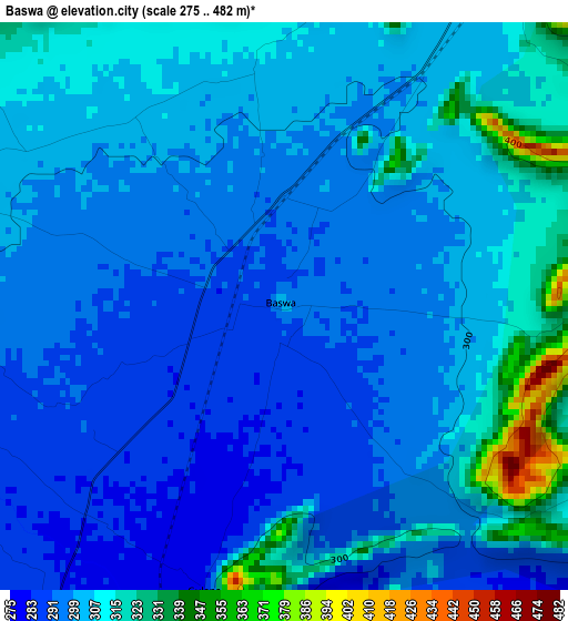
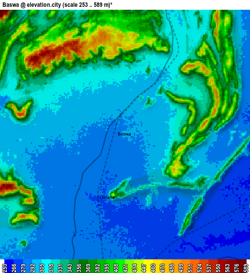
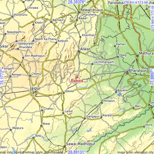
| \ | Map #1 | Map #2 | Topo.Map |
| Scale [m] | 275..482 m | 253..589 m | × |
| Scale [ft] | 902..1581 ft | 830..1932 ft | × |
| Average | 301.8 m = 990 ft | 322.5 m = 1058 ft | × |
| Width | 8.7 km = 5.4 mi | 17.39 km = 10.8 mi | 278.2 km = 172.9 mi |
| Height | 8.7 km = 5.4 mi | 17.39 km = 10.8 mi | 278.3 km = 172.9 mi |
| ↑Max Latitude | 27.188647° | 27.227729° | 28.39378° |
| Latitude at center | 27.14955° | 27.14955° | 27.14955° |
| ↓Min Latitude | 27.11044° | 27.071316° | 25.89131° |
| ← Min Longitude | 76.539505° | 76.495559° | 75.1772° |
| Longitude center | 76.58345° | 76.58345° | 76.58345° |
| →Max Longitude | 76.627395° | 76.671341° | 77.9897° |
Nearby cities:
Cities around Baswa sort by population:
• Alwar elevation 269 m
46.1 km,  5°
5°
• Dausa 353 m
37.9 km,  220°
220°
• Rājgarh 314 m
10.5 km,  21°
21°
• Nagar 203 m
59.4 km,  59°
59°
• Nādbai 201 m
61.1 km,  82°
82°
• Mahwah 237 m
36.3 km,  108°
108°
• Todabhim 252 m
34.7 km,  138°
138°
• Bhasāwar 221 m
47.6 km,  104°
104°
• Wer 222 m
60.5 km, 103°
• Bāndīkūi 283 m
11 km,  185°
185°
• Govindgarh 219 m
56.9 km,  46°
46°
• Abhaneri 280 m
16 km,  171°
171°
Multilingual:
 En español:
Baswa elevación 299 m.
 En France:
Baswa élévation 299 m.


Sources and notes:
- [note 1] Map square and city borders are not equal. Map elevation data is calculated only from area inside that square.
- [src 1] Elevation data from geonames database provided with same terms of usage.
- [src 2] The elevation map of Baswa is generated using elevation data from NASA's 3 arcsec (90m) resolution SRTM data.
- [src 3] Base (background) map © OpenStreetMap contributors tiles are generated by Geofabrik and OpenTopoMap.
Copyright & License:
This Baswa Elevation Map is licensed under CC BY-SA. You may reuse any part from this page, if you give a proper credit by linking to this URL:
 More info on terms of use page.