Lālsot elevation
Lālsot (Rajasthan, Dausa), India elevation is 308 meters and Lālsot elevation in feet is 1010 ft above sea level [src 1]. Lālsot is a populated place (feature code) with elevation that is 15 meters (49 ft) bigger than average city elevation in India.
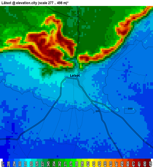
Below is the Elevation map of Lālsot, which displays elevation range with different colors. Scale of the first map is from 277 to 498 m (909 to 1634 ft) with average elevation of 325.9 meters (=1069 ft) [note 1]
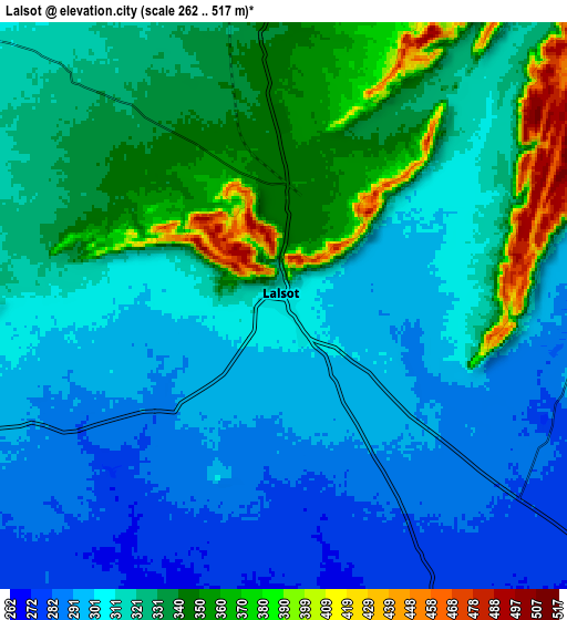
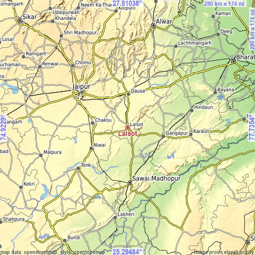
These maps also provides idea of topography and contour of this city, they are displayed at different zoom levels. More info about maps, scale and edge coordinates you can find below images.
| \ | Map #1 | Map #2 | Topo.Map |
| Scale [m] | 277..498 m | 262..517 m | × |
| Scale [ft] | 909..1634 ft | 860..1696 ft | × |
| Average | 325.9 m = 1069 ft | 318.8 m = 1046 ft | × |
| Width | 8.74 km = 5.4 mi | 17.48 km = 10.9 mi | 279.7 km = 173.8 mi |
| Height | 8.74 km = 5.4 mi | 17.48 km = 10.9 mi | 279.7 km = 173.8 mi |
| ↑Max Latitude | 26.598811° | 26.638099° | 27.81038° |
| Latitude at center | 26.55951° | 26.55951° | 26.55951° |
| ↓Min Latitude | 26.520195° | 26.480867° | 25.29484° |
| ← Min Longitude | 76.285205° | 76.241259° | 74.9229° |
| Longitude center | 76.32915° | 76.32915° | 76.32915° |
| →Max Longitude | 76.373095° | 76.417041° | 77.7354° |
Nearby cities:
Cities around Lālsot sort by population:
• Jaipur elevation 435 m
67 km,  306°
306°
• Tonk 278 m
69.4 km,  230°
230°
• Gangāpur 262 m
39.8 km,  104°
104°
• Sawāi Mādhopur 257 m
59.7 km,  178°
178°
• Karauli 272 m
69.8 km, 95°
• Dausa 353 m
36.8 km,  1°
1°
• Niwai 347 m
46.5 km,  241°
241°
• Chaksu 304 m
38.2 km,  277°
277°
• Todabhim 252 m
62.6 km,  50°
50°
• Basi 361 m
41.1 km,  317°
317°
• Bāndīkūi 283 m
59.8 km,  23°
23°
• Abhaneri 280 m
57 km,  29°
29°
Multilingual:
 En español:
Lālsot elevación 308 m.
 En France:
Lālsot élévation 308 m.


Sources and notes:
- [note 1] Map square and city borders are not equal. Map elevation data is calculated only from area inside that square.
- [src 1] Elevation data from geonames database provided with same terms of usage.
- [src 2] The elevation map of Lālsot is generated using elevation data from NASA's 3 arcsec (90m) resolution SRTM data.
- [src 3] Base (background) map © OpenStreetMap contributors tiles are generated by Geofabrik and OpenTopoMap.
Copyright & License:
This Lālsot Elevation Map is licensed under CC BY-SA. You may reuse any part from this page, if you give a proper credit by linking to this URL:
 More info on terms of use page.