Bhātāpāra elevation
Bhātāpāra (Chhattisgarh, Raipur), India elevation is 275 meters and Bhātāpāra elevation in feet is 902 ft above sea level [src 1]. Bhātāpāra is a populated place (feature code) with elevation that is 18 meters (59 ft) smaller than average city elevation in India.
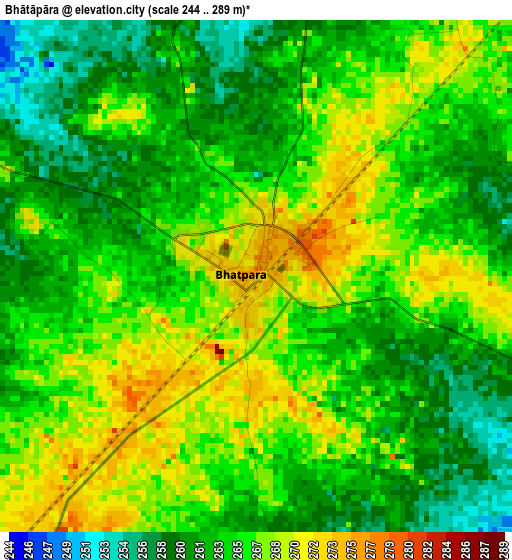
Below is the Elevation map of Bhātāpāra, which displays elevation range with different colors. Scale of the first map is from 244 to 289 m (801 to 948 ft) with average elevation of 264.6 meters (=868 ft) [note 1]
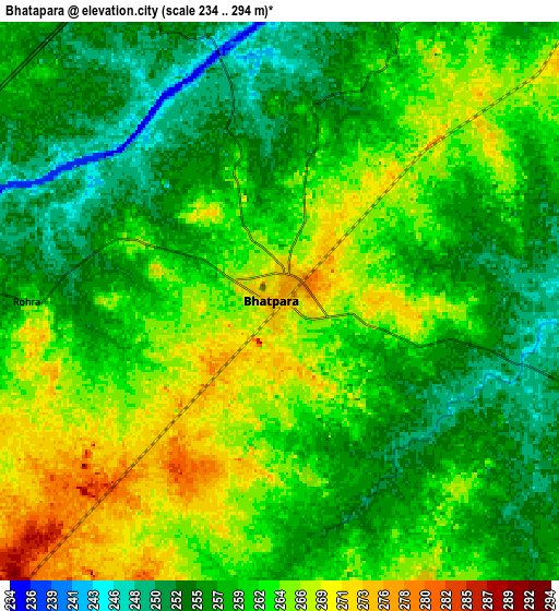
These maps also provides idea of topography and contour of this city, they are displayed at different zoom levels. More info about maps, scale and edge coordinates you can find below images.
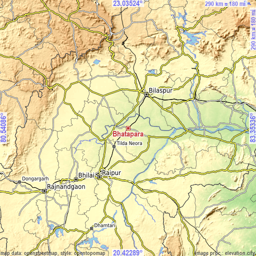
| \ | Map #1 | Map #2 | Topo.Map |
| Scale [m] | 244..289 m | 234..294 m | × |
| Scale [ft] | 801..948 ft | 768..965 ft | × |
| Average | 264.6 m = 868 ft | 260.5 m = 855 ft | × |
| Width | 9.08 km = 5.6 mi | 18.16 km = 11.3 mi | 290.5 km = 180.5 mi |
| Height | 9.08 km = 5.6 mi | 18.16 km = 11.3 mi | 290.5 km = 180.5 mi |
| ↑Max Latitude | 21.775815° | 21.816619° | 23.03524° |
| Latitude at center | 21.735° | 21.735° | 21.735° |
| ↓Min Latitude | 21.694173° | 21.653335° | 20.42289° |
| ← Min Longitude | 81.903165° | 81.859219° | 80.54086° |
| Longitude center | 81.94711° | 81.94711° | 81.94711° |
| →Max Longitude | 81.991055° | 82.035001° | 83.35336° |
Nearby cities:
Cities around Bhātāpāra sort by population:
• Raipur elevation 296 m
64.5 km,  210°
210°
• Bilāspur 265 m
44 km,  29°
29°
• Mungeli 287 m
45.6 km,  323°
323°
• Baloda Bāzār 259 m
23.7 km,  111°
111°
• Bemetāra 291 m
42.7 km,  267°
267°
• Akaltara 287 m
59 km,  56°
56°
• Takhatpur 269 m
44.5 km,  349°
349°
• Arang 284 m
59.9 km,  177°
177°
• Kotā 333 m
62.8 km,  7°
7°
• Simga 270 m
27.8 km,  244°
244°
• Lormi 317 m
65.1 km,  337°
337°
• Kharod 244 m
65.2 km,  89°
89°
Multilingual:
 En español:
Bhātāpāra elevación 275 m.
 En France:
Bhātāpāra élévation 275 m.
 Auf Deutsch:
Bhātāpāra höhe über dem Meeresspiegel ist 275 m.

Sources and notes:
- [note 1] Map square and city borders are not equal. Map elevation data is calculated only from area inside that square.
- [src 1] Elevation data from geonames database provided with same terms of usage.
- [src 2] The elevation map of Bhātāpāra is generated using elevation data from NASA's 3 arcsec (90m) resolution SRTM data.
- [src 3] Base (background) map © OpenStreetMap contributors tiles are generated by Geofabrik and OpenTopoMap.
Copyright & License:
This Bhātāpāra Elevation Map is licensed under CC BY-SA. You may reuse any part from this page, if you give a proper credit by linking to this URL:
 More info on terms of use page.