Chikmagalūr elevation
Chikmagalūr (Karnataka, Chikmagalur), India elevation is 1042 meters and Chikmagalūr elevation in feet is 3419 ft above sea level [src 1]. Chikmagalūr is a populated place (feature code) with elevation that is 749 meters (2457 ft) bigger than average city elevation in India.
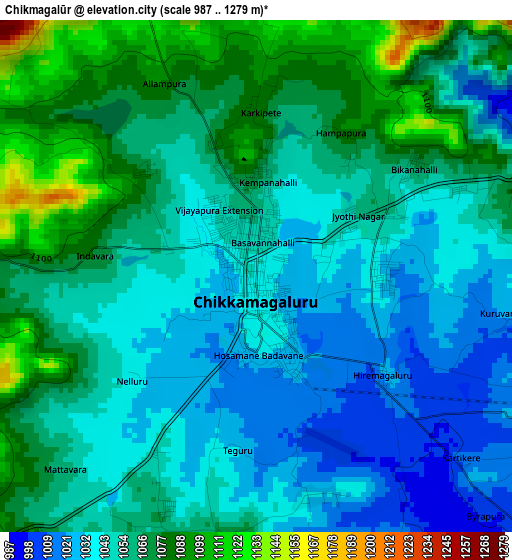
Below is the Elevation map of Chikmagalūr, which displays elevation range with different colors. Scale of the first map is from 987 to 1279 m (3238 to 4196 ft) with average elevation of 1055.1 meters (=3462 ft) [note 1]
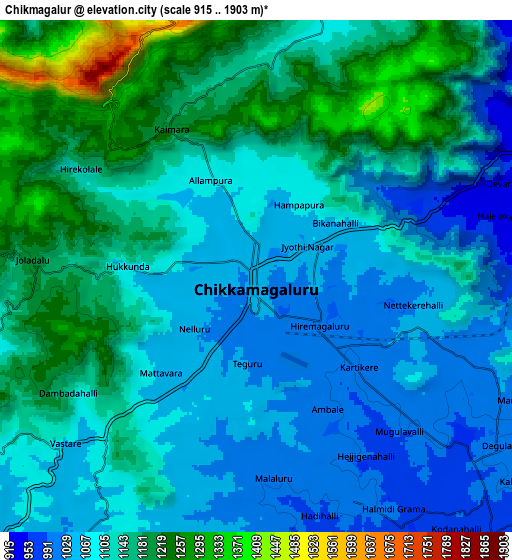
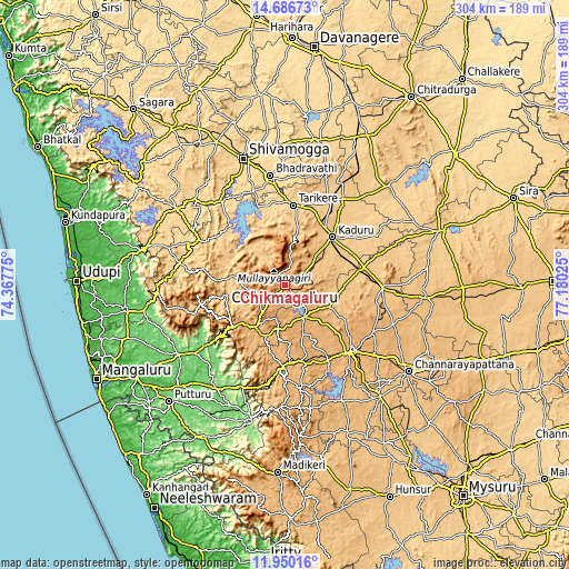
These maps also provides idea of topography and contour of this city, they are displayed at different zoom levels. More info about maps, scale and edge coordinates you can find below images.
| \ | Map #1 | Map #2 | Topo.Map |
| Scale [m] | 987..1279 m | 915..1903 m | × |
| Scale [ft] | 3238..4196 ft | 3002..6243 ft | × |
| Average | 1055.1 m = 3462 ft | 1114.7 m = 3657 ft | × |
| Width | 9.51 km = 5.9 mi | 19.02 km = 11.8 mi | 304.3 km = 189.1 mi |
| Height | 9.51 km = 5.9 mi | 19.02 km = 11.8 mi | 304.3 km = 189.1 mi |
| ↑Max Latitude | 13.365069° | 13.40782° | 14.68673° |
| Latitude at center | 13.32231° | 13.32231° | 13.32231° |
| ↓Min Latitude | 13.279544° | 13.236769° | 11.95016° |
| ← Min Longitude | 75.730055° | 75.686109° | 74.36775° |
| Longitude center | 75.774° | 75.774° | 75.774° |
| →Max Longitude | 75.817945° | 75.861891° | 77.18025° |
Nearby cities:
Cities around Chikmagalūr sort by population:
• Hassan elevation 955 m
49.4 km,  135°
135°
• Tarikere 685 m
43.3 km,  5°
5°
• Kadūr 774 m
36.3 km,  45°
45°
• Sakleshpur 935 m
42.4 km,  178°
178°
• Birūr 799 m
37.3 km,  34°
34°
• Belūr 976 m
20 km,  150°
150°
• Ajjampur 756 m
51.6 km, 29°
• Mudgere 963 m
25.4 km,  214°
214°
• Bānāvar 778 m
43.2 km,  76°
76°
• Narasimharājapura 698 m
42.8 km,  318°
318°
• Alūr 975 m
44.9 km, 148°
• Koppa 778 m
50.1 km,  297°
297°
Multilingual:
 En español:
Chikmagalūr elevación 1042 m.
 En France:
Chikmagalūr élévation 1042 m.
 Auf Deutsch:
Chikmagalūr höhe über dem Meeresspiegel ist 1042 m.

Sources and notes:
- [note 1] Map square and city borders are not equal. Map elevation data is calculated only from area inside that square.
- [src 1] Elevation data from geonames database provided with same terms of usage.
- [src 2] The elevation map of Chikmagalūr is generated using elevation data from NASA's 3 arcsec (90m) resolution SRTM data.
- [src 3] Base (background) map © OpenStreetMap contributors tiles are generated by Geofabrik and OpenTopoMap.
Copyright & License:
This Chikmagalūr Elevation Map is licensed under CC BY-SA. You may reuse any part from this page, if you give a proper credit by linking to this URL:
 More info on terms of use page.