Hassan elevation
Hassan (Karnataka), India elevation is 955 meters and Hassan elevation in feet is 3133 ft above sea level [src 1]. Hassan is a populated place (feature code) with elevation that is 662 meters (2172 ft) bigger than average city elevation in India.
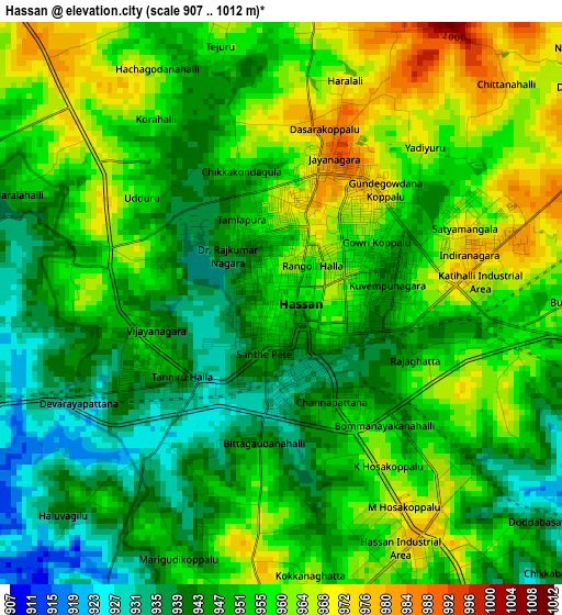
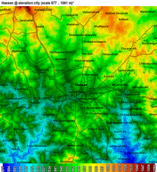
Below is the Elevation map of Hassan, which displays elevation range with different colors. Scale of the first map is from 907 to 1012 m (2976 to 3320 ft) with average elevation of 952.6 meters (=3125 ft) [note 1]
These maps also provides idea of topography and contour of this city, they are displayed at different zoom levels. More info about maps, scale and edge coordinates you can find below images.
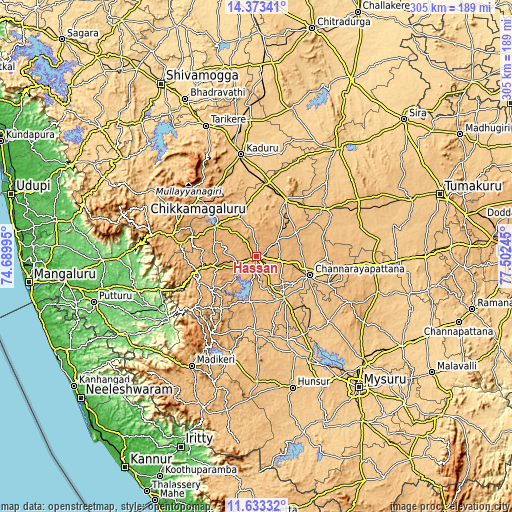
| \ | Map #1 | Map #2 | Topo.Map |
| Scale [m] | 907..1012 m | 877..1061 m | × |
| Scale [ft] | 2976..3320 ft | 2877..3481 ft | × |
| Average | 952.6 m = 3125 ft | 955 m = 3133 ft | × |
| Width | 9.52 km = 5.9 mi | 19.04 km = 11.8 mi | 304.7 km = 189.3 mi |
| Height | 9.52 km = 5.9 mi | 19.04 km = 11.8 mi | 304.7 km = 189.3 mi |
| ↑Max Latitude | 13.049964° | 13.092771° | 14.37341° |
| Latitude at center | 13.00715° | 13.00715° | 13.00715° |
| ↓Min Latitude | 12.964329° | 12.9215° | 11.63332° |
| ← Min Longitude | 76.052255° | 76.008309° | 74.68995° |
| Longitude center | 76.0962° | 76.0962° | 76.0962° |
| →Max Longitude | 76.140145° | 76.184091° | 77.50245° |
Nearby cities:
Cities around Hassan sort by population:
• Arsikere elevation 809 m
38.4 km,  27°
27°
• Channarāyapatna 855 m
33.5 km,  109°
109°
• Hole Narsipur 845 m
29.3 km,  146°
146°
• Sakleshpur 935 m
34.5 km,  257°
257°
• Belūr 976 m
30.6 km,  305°
305°
• Arkalgūd 922 m
27.6 km,  188°
188°
• Konanūr 835 m
42.2 km, 186°
• Bānāvar 778 m
45.4 km,  9°
9°
• Alūr 975 m
11.9 km,  254°
254°
• Gorūr 878 m
20.8 km, 189°
• Sanivārsante 960 m
38.4 km,  216°
216°
• Kodlipet 954 m
32.3 km, 224°
Multilingual:
 En español:
Hassan elevación 955 m.
 En France:
Hassan élévation 955 m.


Sources and notes:
- [note 1] Map square and city borders are not equal. Map elevation data is calculated only from area inside that square.
- [src 1] Elevation data from geonames database provided with same terms of usage.
- [src 2] The elevation map of Hassan is generated using elevation data from NASA's 3 arcsec (90m) resolution SRTM data.
- [src 3] Base (background) map © OpenStreetMap contributors tiles are generated by Geofabrik and OpenTopoMap.
Copyright & License:
This Hassan Elevation Map is licensed under CC BY-SA. You may reuse any part from this page, if you give a proper credit by linking to this URL:
 More info on terms of use page.