Dādri elevation
Dādri (Uttar Pradesh, Gautam Buddha Nagar), India elevation is 214 meters and Dādri elevation in feet is 702 ft above sea level [src 1]. Dādri is a populated place (feature code) with elevation that is 79 meters (259 ft) smaller than average city elevation in India.
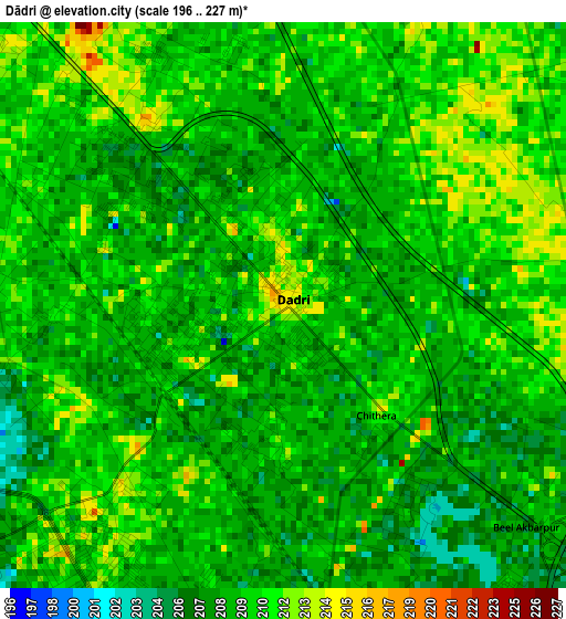
Below is the Elevation map of Dādri, which displays elevation range with different colors. Scale of the first map is from 196 to 227 m (643 to 745 ft) with average elevation of 209.1 meters (=686 ft) [note 1]
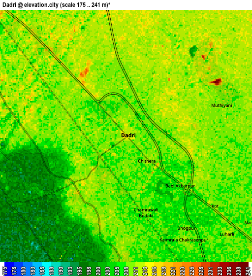
These maps also provides idea of topography and contour of this city, they are displayed at different zoom levels. More info about maps, scale and edge coordinates you can find below images.
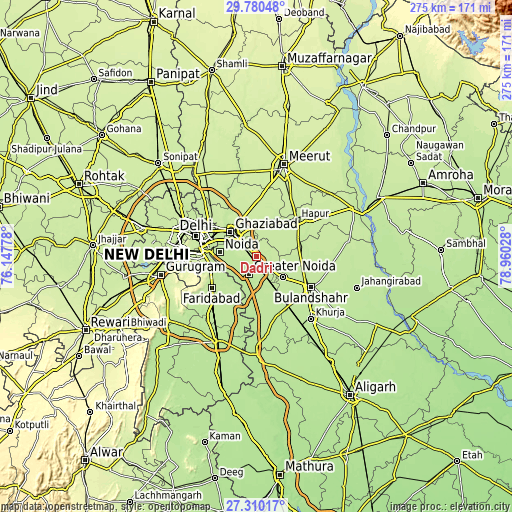
| \ | Map #1 | Map #2 | Topo.Map |
| Scale [m] | 196..227 m | 175..241 m | × |
| Scale [ft] | 643..745 ft | 574..791 ft | × |
| Average | 209.1 m = 686 ft | 208.1 m = 683 ft | × |
| Width | 8.58 km = 5.3 mi | 17.17 km = 10.7 mi | 274.7 km = 170.7 mi |
| Height | 8.58 km = 5.3 mi | 17.17 km = 10.7 mi | 274.7 km = 170.7 mi |
| ↑Max Latitude | 28.591164° | 28.629743° | 29.78048° |
| Latitude at center | 28.55257° | 28.55257° | 28.55257° |
| ↓Min Latitude | 28.513962° | 28.47534° | 27.31017° |
| ← Min Longitude | 77.510085° | 77.466139° | 76.14778° |
| Longitude center | 77.55403° | 77.55403° | 77.55403° |
| →Max Longitude | 77.597975° | 77.641921° | 78.96028° |
Nearby cities:
Cities around Dādri sort by population:
• Ghāziābād elevation 214 m
16.8 km,  318°
318°
• Noida 206 m
22.1 km,  277°
277°
• Greater Noida 212 m
6.5 km,  195°
195°
• Murādnagar 222 m
25.9 km,  347°
347°
• Pilkhua 220 m
20.4 km,  29°
29°
• Sikandarābād 209 m
18.1 km,  128°
128°
• Gulāothi 211 m
23.7 km,  80°
80°
• Dāsna 221 m
14.2 km, 347°
• Dankaur 207 m
22.4 km,  179°
179°
• Farīdnagar 219 m
25.2 km,  16°
16°
• Bīlāspur 207 m
19.2 km,  159°
159°
• Sector 207 m
22.4 km, 275°
Multilingual:
 En español:
Dādri elevación 214 m.
 En France:
Dādri élévation 214 m.


Sources and notes:
- [note 1] Map square and city borders are not equal. Map elevation data is calculated only from area inside that square.
- [src 1] Elevation data from geonames database provided with same terms of usage.
- [src 2] The elevation map of Dādri is generated using elevation data from NASA's 3 arcsec (90m) resolution SRTM data.
- [src 3] Base (background) map © OpenStreetMap contributors tiles are generated by Geofabrik and OpenTopoMap.
Copyright & License:
This Dādri Elevation Map is licensed under CC BY-SA. You may reuse any part from this page, if you give a proper credit by linking to this URL:
 More info on terms of use page.