Heggadadevankote elevation
Heggadadevankote (Karnataka, Mysore), India elevation is 702 meters and Heggadadevankote elevation in feet is 2303 ft above sea level [src 1]. Heggadadevankote is a populated place (feature code) with elevation that is 409 meters (1342 ft) bigger than average city elevation in India.
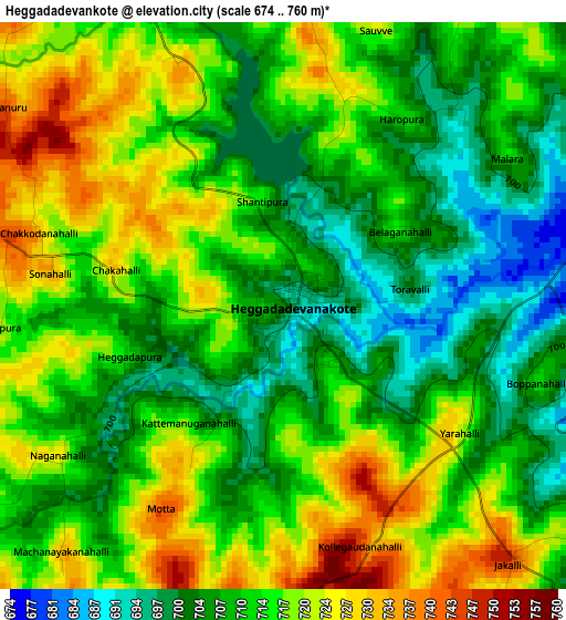
Below is the Elevation map of Heggadadevankote, which displays elevation range with different colors. Scale of the first map is from 674 to 760 m (2211 to 2493 ft) with average elevation of 712.7 meters (=2338 ft) [note 1]
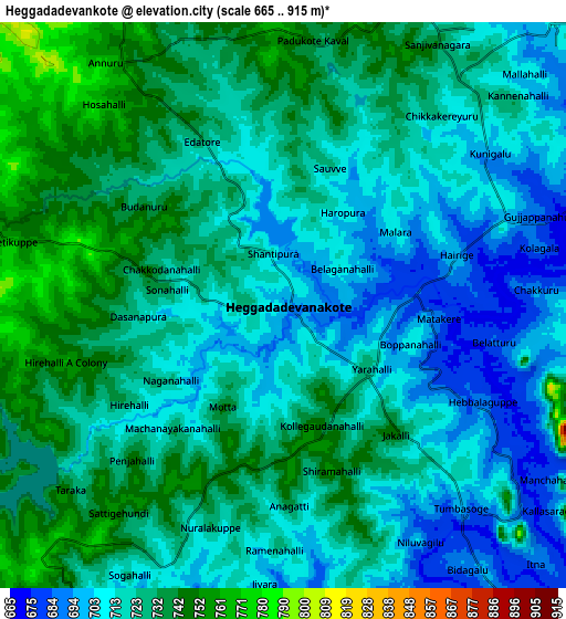
These maps also provides idea of topography and contour of this city, they are displayed at different zoom levels. More info about maps, scale and edge coordinates you can find below images.
| \ | Map #1 | Map #2 | Topo.Map |
| Scale [m] | 674..760 m | 665..915 m | × |
| Scale [ft] | 2211..2493 ft | 2182..3002 ft | × |
| Average | 712.7 m = 2338 ft | 721.5 m = 2367 ft | × |
| Width | 9.56 km = 5.9 mi | 19.11 km = 11.9 mi | 305.8 km = 190 mi |
| Height | 9.56 km = 5.9 mi | 19.11 km = 11.9 mi | 305.8 km = 190 mi |
| ↑Max Latitude | 12.131057° | 12.174018° | 13.4595° |
| Latitude at center | 12.08809° | 12.08809° | 12.08809° |
| ↓Min Latitude | 12.045116° | 12.002134° | 10.70961° |
| ← Min Longitude | 76.285625° | 76.241679° | 74.92332° |
| Longitude center | 76.32957° | 76.32957° | 76.32957° |
| →Max Longitude | 76.373515° | 76.417461° | 77.73582° |
Nearby cities:
Cities around Heggadadevankote sort by population:
• Mysore elevation 757 m
41 km,  55°
55°
• Nanjangūd 666 m
38.7 km,  85°
85°
• Hunsūr 794 m
24.3 km,  350°
350°
• Gundlupēt 799 m
50 km,  128°
128°
• Shrīrangapattana 689 m
53.6 km,  46°
46°
• Piriyāpatna 859 m
37 km,  317°
317°
• Vīrarājendrapet 899 m
58.3 km,  281°
281°
• Kushālnagar 847 m
57.5 km, 315°
• Perya 742 m
59 km,  241°
241°
• Panamaram 728 m
47.7 km,  215°
215°
• Sargūr 693 m
12.2 km,  143°
143°
• Ponnampet 858 m
42.3 km, 278°
Multilingual:
 En español:
Heggadadevankote elevación 702 m.
 En France:
Heggadadevankote élévation 702 m.
 Auf Deutsch:
Heggadadevankote höhe über dem Meeresspiegel ist 702 m.

Sources and notes:
- [note 1] Map square and city borders are not equal. Map elevation data is calculated only from area inside that square.
- [src 1] Elevation data from geonames database provided with same terms of usage.
- [src 2] The elevation map of Heggadadevankote is generated using elevation data from NASA's 3 arcsec (90m) resolution SRTM data.
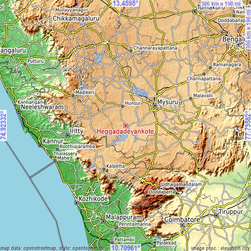
- [src 3] Base (background) map © OpenStreetMap contributors tiles are generated by Geofabrik and OpenTopoMap.
Copyright & License:
This Heggadadevankote Elevation Map is licensed under CC BY-SA. You may reuse any part from this page, if you give a proper credit by linking to this URL:
 More info on terms of use page.