Jhā-Jhā elevation
Jhā-Jhā (Bihar, Jamui), India elevation is 139 meters and Jhā-Jhā elevation in feet is 456 ft above sea level [src 1]. Jhā-Jhā is a populated place (feature code) with elevation that is 154 meters (505 ft) smaller than average city elevation in India.
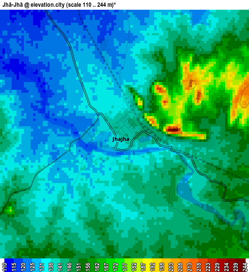
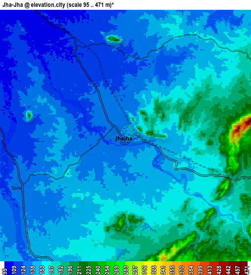
Below is the Elevation map of Jhā-Jhā, which displays elevation range with different colors. Scale of the first map is from 110 to 244 m (361 to 801 ft) with average elevation of 141.1 meters (=463 ft) [note 1]
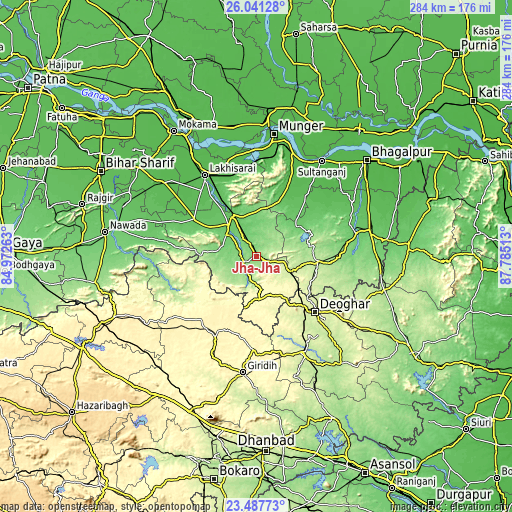
These maps also provides idea of topography and contour of this city, they are displayed at different zoom levels. More info about maps, scale and edge coordinates you can find below images.
| \ | Map #1 | Map #2 | Topo.Map |
| Scale [m] | 110..244 m | 95..471 m | × |
| Scale [ft] | 361..801 ft | 312..1545 ft | × |
| Average | 141.1 m = 463 ft | 150.2 m = 493 ft | × |
| Width | 8.87 km = 5.5 mi | 17.75 km = 11 mi | 283.9 km = 176.4 mi |
| Height | 8.87 km = 5.5 mi | 17.75 km = 11 mi | 283.9 km = 176.4 mi |
| ↑Max Latitude | 24.810965° | 24.850848° | 26.04128° |
| Latitude at center | 24.77107° | 24.77107° | 24.77107° |
| ↓Min Latitude | 24.731162° | 24.691241° | 23.48773° |
| ← Min Longitude | 86.334935° | 86.290989° | 84.97263° |
| Longitude center | 86.37888° | 86.37888° | 86.37888° |
| →Max Longitude | 86.422825° | 86.466771° | 87.78513° |
Nearby cities:
Cities around Jhā-Jhā sort by population:
• Jamālpur elevation 52 m
61.2 km,  10°
10°
• Luckeesarai 50 m
53.4 km,  327°
327°
• Jamūī 88 m
23.2 km,  318°
318°
• Gīrīdīh 305 m
65.4 km,  186°
186°
• Madhupur 250 m
61.2 km,  154°
154°
• Bānka 85 m
56.2 km,  77°
77°
• Kharagpur 57 m
43.2 km,  24°
24°
• Amarpur 64 m
60.7 km,  60°
60°
• Jasidih 272 m
39.3 km,  136°
136°
• Bariārpur 44 m
60.8 km, 19°
• Dhanwār 355 m
56.7 km,  225°
225°
• Asarganj 51 m
52.3 km,  36°
36°
Multilingual:
 En español:
Jhā-Jhā elevación 139 m.
 En France:
Jhā-Jhā élévation 139 m.


Sources and notes:
- [note 1] Map square and city borders are not equal. Map elevation data is calculated only from area inside that square.
- [src 1] Elevation data from geonames database provided with same terms of usage.
- [src 2] The elevation map of Jhā-Jhā is generated using elevation data from NASA's 3 arcsec (90m) resolution SRTM data.
- [src 3] Base (background) map © OpenStreetMap contributors tiles are generated by Geofabrik and OpenTopoMap.
Copyright & License:
This Jhā-Jhā Elevation Map is licensed under CC BY-SA. You may reuse any part from this page, if you give a proper credit by linking to this URL:
 More info on terms of use page.