Junnar elevation
Junnar (Maharashtra, Pune Division), India elevation is 683 meters and Junnar elevation in feet is 2241 ft above sea level [src 1]. Junnar is a populated place (feature code) with elevation that is 390 meters (1280 ft) bigger than average city elevation in India.
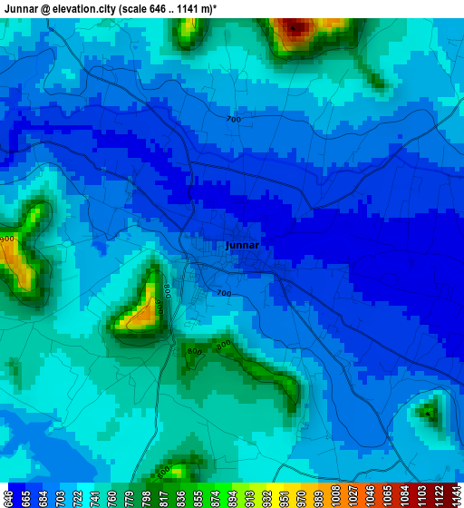
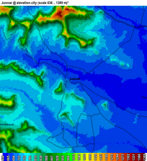
Below is the Elevation map of Junnar, which displays elevation range with different colors. Scale of the first map is from 646 to 1141 m (2119 to 3743 ft) with average elevation of 717.6 meters (=2354 ft) [note 1]
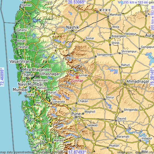
These maps also provides idea of topography and contour of this city, they are displayed at different zoom levels. More info about maps, scale and edge coordinates you can find below images.
| \ | Map #1 | Map #2 | Topo.Map |
| Scale [m] | 646..1141 m | 636..1389 m | × |
| Scale [ft] | 2119..3743 ft | 2087..4557 ft | × |
| Average | 717.6 m = 2354 ft | 744 m = 2441 ft | × |
| Width | 9.23 km = 5.7 mi | 18.46 km = 11.5 mi | 295.3 km = 183.5 mi |
| Height | 9.23 km = 5.7 mi | 18.46 km = 11.5 mi | 295.3 km = 183.5 mi |
| ↑Max Latitude | 19.249644° | 19.291127° | 20.53065° |
| Latitude at center | 19.20815° | 19.20815° | 19.20815° |
| ↓Min Latitude | 19.166646° | 19.125131° | 17.87493° |
| ← Min Longitude | 73.831255° | 73.787309° | 72.46895° |
| Longitude center | 73.8752° | 73.8752° | 73.8752° |
| →Max Longitude | 73.919145° | 73.963091° | 75.28145° |
Nearby cities:
Cities around Junnar sort by population:
• Sangamner elevation 557 m
53.3 km,  41°
41°
• Talegaon Dābhāde 632 m
56.6 km,  201°
201°
• Kalamb 629 m
20.1 km,  155°
155°
• Chākan 619 m
49.8 km,  181°
181°
• Ghoti Budrukh 593 m
62.2 km,  335°
335°
• Alandi 572 m
59 km, 177°
• Rājgurunagar 626 m
38.1 km, 176°
• Murbād 79 m
51.2 km,  275°
275°
• Neral 46 m
62.1 km,  250°
250°
• Manchar 674 m
23.8 km, 162°
• Wadgaon 631 m
57.7 km,  205°
205°
• Dehu 585 m
55.6 km,  191°
191°
Multilingual:
 En español:
Junnar elevación 683 m.
 En France:
Junnar élévation 683 m.


Sources and notes:
- [note 1] Map square and city borders are not equal. Map elevation data is calculated only from area inside that square.
- [src 1] Elevation data from geonames database provided with same terms of usage.
- [src 2] The elevation map of Junnar is generated using elevation data from NASA's 3 arcsec (90m) resolution SRTM data.
- [src 3] Base (background) map © OpenStreetMap contributors tiles are generated by Geofabrik and OpenTopoMap.
Copyright & License:
This Junnar Elevation Map is licensed under CC BY-SA. You may reuse any part from this page, if you give a proper credit by linking to this URL:
 More info on terms of use page.