Kalamb elevation
Kalamb (Maharashtra, Pune Division), India elevation is 629 meters and Kalamb elevation in feet is 2064 ft above sea level [src 1]. Kalamb is a populated place (feature code) with elevation that is 336 meters (1102 ft) bigger than average city elevation in India.
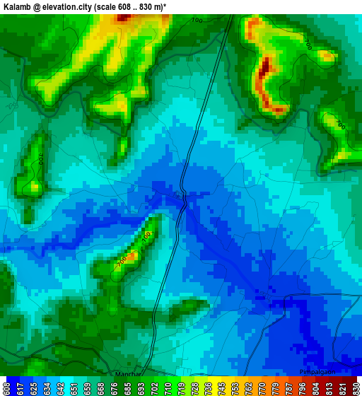
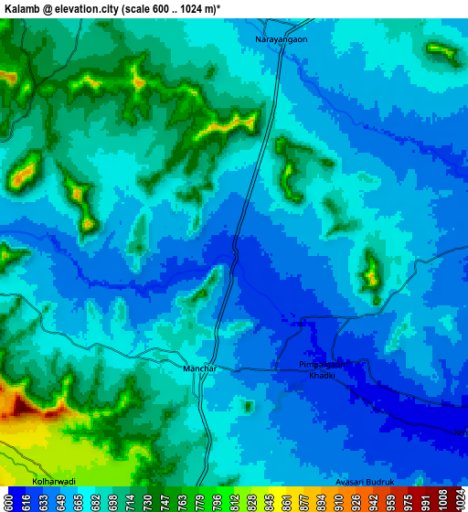
Below is the Elevation map of Kalamb, which displays elevation range with different colors. Scale of the first map is from 608 to 830 m (1995 to 2723 ft) with average elevation of 661.1 meters (=2169 ft) [note 1]
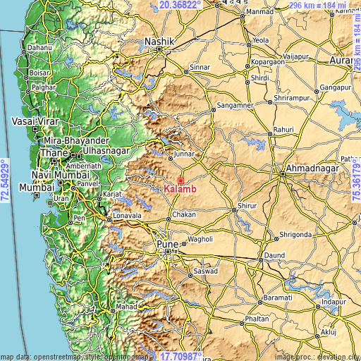
These maps also provides idea of topography and contour of this city, they are displayed at different zoom levels. More info about maps, scale and edge coordinates you can find below images.
| \ | Map #1 | Map #2 | Topo.Map |
| Scale [m] | 608..830 m | 600..1024 m | × |
| Scale [ft] | 1995..2723 ft | 1969..3360 ft | × |
| Average | 661.1 m = 2169 ft | 680.9 m = 2234 ft | × |
| Width | 9.24 km = 5.7 mi | 18.48 km = 11.5 mi | 295.6 km = 183.7 mi |
| Height | 9.24 km = 5.7 mi | 18.48 km = 11.5 mi | 295.6 km = 183.7 mi |
| ↑Max Latitude | 19.085905° | 19.127429° | 20.36822° |
| Latitude at center | 19.04437° | 19.04437° | 19.04437° |
| ↓Min Latitude | 19.002825° | 18.961269° | 17.70987° |
| ← Min Longitude | 73.911595° | 73.867649° | 72.54929° |
| Longitude center | 73.95554° | 73.95554° | 73.95554° |
| →Max Longitude | 73.999485° | 74.043431° | 75.36179° |
Nearby cities:
Cities around Kalamb sort by population:
• Pimpri elevation 571 m
49.4 km,  198°
198°
• Talegaon Dābhāde 632 m
45.3 km,  220°
220°
• Sirūr 568 m
50.2 km,  118°
118°
• Junnar 683 m
20.1 km,  335°
335°
• Koregaon 552 m
45.6 km,  166°
166°
• Chākan 619 m
33 km, 197°
• Alandi 572 m
41.2 km,  188°
188°
• Rājgurunagar 626 m
20.6 km, 196°
• Manchar 674 m
4.6 km, 195°
• Lohogaon 597 m
49.6 km,  183°
183°
• Wadgaon 631 m
47.5 km, 224°
• Dehu 585 m
41.3 km,  208°
208°
Multilingual:
 En español:
Kalamb elevación 629 m.
 En France:
Kalamb élévation 629 m.


Sources and notes:
- [note 1] Map square and city borders are not equal. Map elevation data is calculated only from area inside that square.
- [src 1] Elevation data from geonames database provided with same terms of usage.
- [src 2] The elevation map of Kalamb is generated using elevation data from NASA's 3 arcsec (90m) resolution SRTM data.
- [src 3] Base (background) map © OpenStreetMap contributors tiles are generated by Geofabrik and OpenTopoMap.
Copyright & License:
This Kalamb Elevation Map is licensed under CC BY-SA. You may reuse any part from this page, if you give a proper credit by linking to this URL:
 More info on terms of use page.