Karīmganj elevation
Karīmganj (Assam, Karimganj), India elevation is 25 meters and Karīmganj elevation in feet is 82 ft above sea level [src 1]. Karīmganj is a populated place (feature code) with elevation that is 268 meters (879 ft) smaller than average city elevation in India.
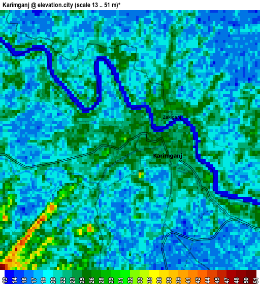
Below is the Elevation map of Karīmganj, which displays elevation range with different colors. Scale of the first map is from 13 to 51 m (43 to 167 ft) with average elevation of 20.6 meters (=68 ft) [note 1]
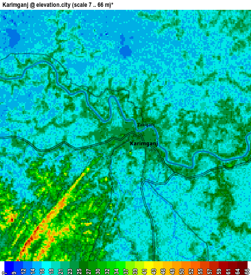
These maps also provides idea of topography and contour of this city, they are displayed at different zoom levels. More info about maps, scale and edge coordinates you can find below images.
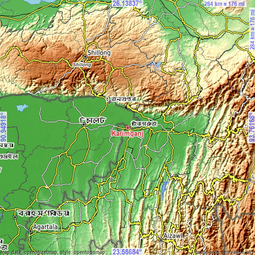
| \ | Map #1 | Map #2 | Topo.Map |
| Scale [m] | 13..51 m | 7..66 m | × |
| Scale [ft] | 43..167 ft | 23..217 ft | × |
| Average | 20.6 m = 68 ft | 20.6 m = 68 ft | × |
| Width | 8.87 km = 5.5 mi | 17.73 km = 11 mi | 283.7 km = 176.3 mi |
| Height | 8.87 km = 5.5 mi | 17.73 km = 11 mi | 283.7 km = 176.3 mi |
| ↑Max Latitude | 24.909054° | 24.948905° | 26.13837° |
| Latitude at center | 24.86919° | 24.86919° | 24.86919° |
| ↓Min Latitude | 24.829313° | 24.789424° | 23.58684° |
| ← Min Longitude | 92.311485° | 92.267539° | 90.94918° |
| Longitude center | 92.35543° | 92.35543° | 92.35543° |
| →Max Longitude | 92.399375° | 92.443321° | 93.76168° |
Nearby cities:
Cities around Karīmganj sort by population:
• Silchar elevation 24 m
44.9 km,  95°
95°
• Hāflong 684 m
74.4 km,  63°
63°
• Dharmanagar 32 m
59 km,  198°
198°
• Hailākāndi 30 m
29.2 km,  134°
134°
• Kolasib 661 m
78.8 km,  155°
155°
• Kailāshahar 32 m
69.5 km,  210°
210°
• Lakhipur 35 m
66.5 km, 97°
• Cherrapunji 1505 m
81.9 km,  305°
305°
• Badarpur 62 m
24.3 km,  90°
90°
• Lāla 34 m
43.8 km,  143°
143°
• Jiribam 33 m
77.6 km, 95°
• Khliehriat 1141 m
54.3 km,  1°
1°
Multilingual:
 En español:
Karīmganj elevación 25 m.
 En France:
Karīmganj élévation 25 m.
 Auf Deutsch:
Karīmganj höhe über dem Meeresspiegel ist 25 m.

Sources and notes:
- [note 1] Map square and city borders are not equal. Map elevation data is calculated only from area inside that square.
- [src 1] Elevation data from geonames database provided with same terms of usage.
- [src 2] The elevation map of Karīmganj is generated using elevation data from NASA's 3 arcsec (90m) resolution SRTM data.
- [src 3] Base (background) map © OpenStreetMap contributors tiles are generated by Geofabrik and OpenTopoMap.
Copyright & License:
This Karīmganj Elevation Map is licensed under CC BY-SA. You may reuse any part from this page, if you give a proper credit by linking to this URL:
 More info on terms of use page.