Hāflong elevation
Hāflong (Assam, Dima Hasao District), India elevation is 684 meters and Hāflong elevation in feet is 2244 ft above sea level [src 1]. Hāflong is a populated place (feature code) with elevation that is 391 meters (1283 ft) bigger than average city elevation in India.
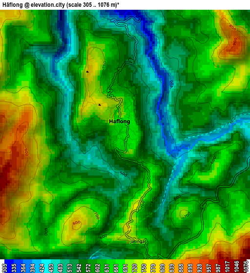
Below is the Elevation map of Hāflong, which displays elevation range with different colors. Scale of the first map is from 305 to 1076 m (1001 to 3530 ft) with average elevation of 616.4 meters (=2022 ft) [note 1]
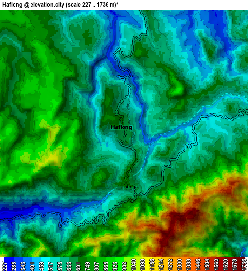
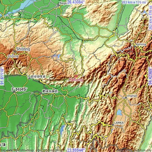
These maps also provides idea of topography and contour of this city, they are displayed at different zoom levels. More info about maps, scale and edge coordinates you can find below images.
| \ | Map #1 | Map #2 | Topo.Map |
| Scale [m] | 305..1076 m | 227..1736 m | × |
| Scale [ft] | 1001..3530 ft | 745..5696 ft | × |
| Average | 616.4 m = 2022 ft | 706.1 m = 2317 ft | × |
| Width | 8.84 km = 5.5 mi | 17.69 km = 11 mi | 283 km = 175.8 mi |
| Height | 8.85 km = 5.5 mi | 17.69 km = 11 mi | 283 km = 175.8 mi |
| ↑Max Latitude | 25.204548° | 25.244303° | 26.43084° |
| Latitude at center | 25.16478° | 25.16478° | 25.16478° |
| ↓Min Latitude | 25.124999° | 25.085205° | 23.88544° |
| ← Min Longitude | 92.973495° | 92.929549° | 91.61119° |
| Longitude center | 93.01744° | 93.01744° | 93.01744° |
| →Max Longitude | 93.061385° | 93.105331° | 94.42369° |
Nearby cities:
Cities around Hāflong sort by population:
• Silchar elevation 24 m
43.6 km,  210°
210°
• Diphu 200 m
86.1 km,  28°
28°
• Karīmganj 25 m
74.4 km,  243°
243°
• Hailākāndi 30 m
70.5 km,  220°
220°
• Lumding Railway Colony 141 m
66.7 km,  13°
13°
• Lakhipur 35 m
41.4 km,  181°
181°
• Badarpur 62 m
53.7 km,  232°
232°
• Lāla 34 m
79.1 km, 210°
• Maibong 295 m
19.4 km,  38°
38°
• Mahur 599 m
9.9 km,  78°
78°
• Khliehriat 1141 m
68.9 km,  288°
288°
• Jiribam 33 m
41.4 km,  165°
165°
Multilingual:
 En español:
Hāflong elevación 684 m.
 En France:
Hāflong élévation 684 m.


Sources and notes:
- [note 1] Map square and city borders are not equal. Map elevation data is calculated only from area inside that square.
- [src 1] Elevation data from geonames database provided with same terms of usage.
- [src 2] The elevation map of Hāflong is generated using elevation data from NASA's 3 arcsec (90m) resolution SRTM data.
- [src 3] Base (background) map © OpenStreetMap contributors tiles are generated by Geofabrik and OpenTopoMap.
Copyright & License:
This Hāflong Elevation Map is licensed under CC BY-SA. You may reuse any part from this page, if you give a proper credit by linking to this URL:
 More info on terms of use page.