Kharar elevation
Kharar (Punjab, Ajitgarh), India elevation is 313 meters and Kharar elevation in feet is 1027 ft above sea level [src 1]. Kharar is a populated place (feature code) with elevation that is 20 meters (66 ft) bigger than average city elevation in India.
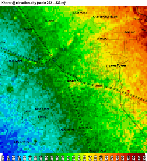
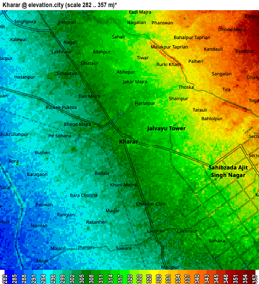
Below is the Elevation map of Kharar, which displays elevation range with different colors. Scale of the first map is from 292 to 333 m (958 to 1093 ft) with average elevation of 309.5 meters (=1015 ft) [note 1]
These maps also provides idea of topography and contour of this city, they are displayed at different zoom levels. More info about maps, scale and edge coordinates you can find below images.
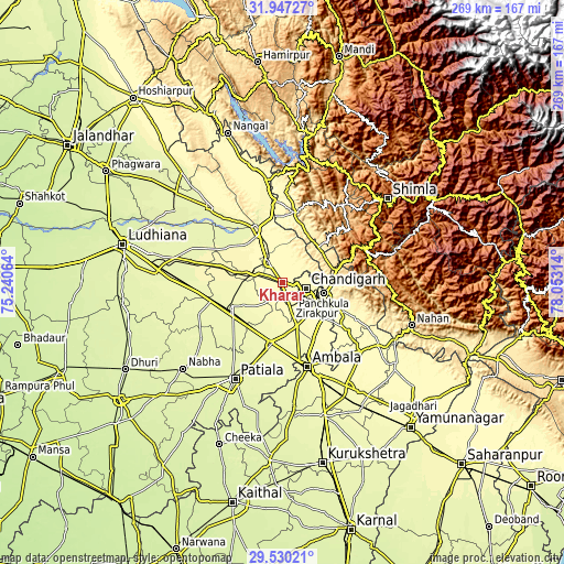
| \ | Map #1 | Map #2 | Topo.Map |
| Scale [m] | 292..333 m | 282..357 m | × |
| Scale [ft] | 958..1093 ft | 925..1171 ft | × |
| Average | 309.5 m = 1015 ft | 310.4 m = 1018 ft | × |
| Width | 8.4 km = 5.2 mi | 16.8 km = 10.4 mi | 268.8 km = 167 mi |
| Height | 8.4 km = 5.2 mi | 16.8 km = 10.4 mi | 268.8 km = 167 mi |
| ↑Max Latitude | 30.784081° | 30.821827° | 31.94727° |
| Latitude at center | 30.74632° | 30.74632° | 30.74632° |
| ↓Min Latitude | 30.708544° | 30.670754° | 29.53021° |
| ← Min Longitude | 76.602945° | 76.558999° | 75.24064° |
| Longitude center | 76.64689° | 76.64689° | 76.64689° |
| →Max Longitude | 76.690835° | 76.734781° | 78.05314° |
Nearby cities:
Cities around Kharar sort by population:
• Chandigarh elevation 351 m
13.6 km,  94°
94°
• Panchkula 335 m
20.3 km,  106°
106°
• Mohali 312 m
10.3 km,  135°
135°
• Sirhind 270 m
27.6 km,  245°
245°
• Ropar 287 m
27.3 km,  335°
335°
• Pinjaur 558 m
26.6 km,  77°
77°
• Morinda 284 m
15 km,  289°
289°
• Baddi 426 m
27.3 km,  30°
30°
• Basi 306 m
25.9 km,  132°
132°
• Basi 275 m
24.4 km, 254°
• Banūr 287 m
22.5 km,  162°
162°
• Khamānon Kalān 275 m
29 km, 285°
Multilingual:
 En español:
Kharar elevación 313 m.
 En France:
Kharar élévation 313 m.


Sources and notes:
- [note 1] Map square and city borders are not equal. Map elevation data is calculated only from area inside that square.
- [src 1] Elevation data from geonames database provided with same terms of usage.
- [src 2] The elevation map of Kharar is generated using elevation data from NASA's 3 arcsec (90m) resolution SRTM data.
- [src 3] Base (background) map © OpenStreetMap contributors tiles are generated by Geofabrik and OpenTopoMap.
Copyright & License:
This Kharar Elevation Map is licensed under CC BY-SA. You may reuse any part from this page, if you give a proper credit by linking to this URL:
 More info on terms of use page.