Kotputli elevation
Kotputli (Rajasthan, Jaipur), India elevation is 361 meters and Kotputli elevation in feet is 1184 ft above sea level [src 1]. Kotputli is a populated place (feature code) with elevation that is 68 meters (223 ft) bigger than average city elevation in India.
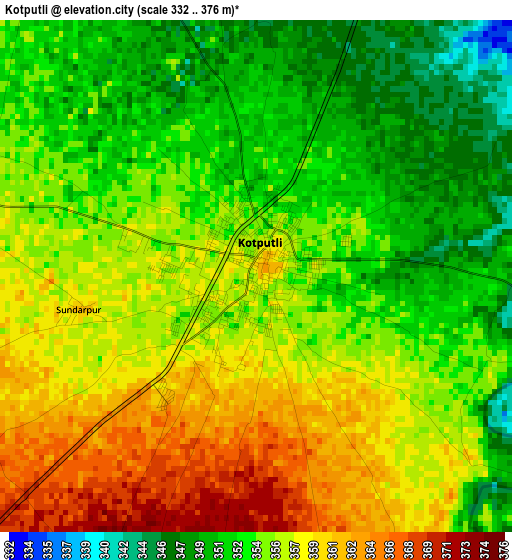
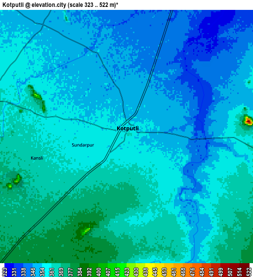
Below is the Elevation map of Kotputli, which displays elevation range with different colors. Scale of the first map is from 332 to 376 m (1089 to 1234 ft) with average elevation of 355.1 meters (=1165 ft) [note 1]
These maps also provides idea of topography and contour of this city, they are displayed at different zoom levels. More info about maps, scale and edge coordinates you can find below images.
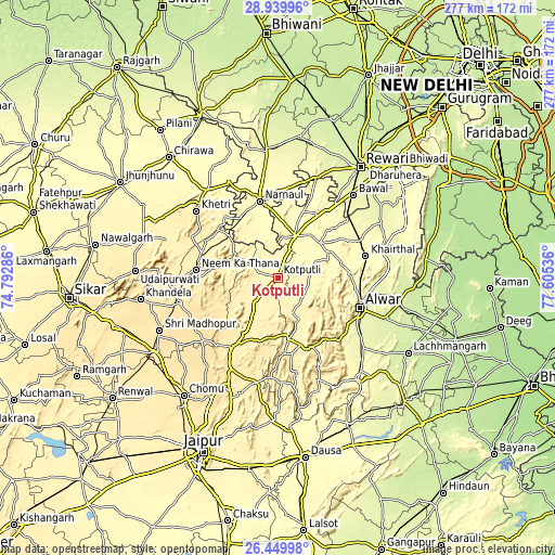
| \ | Map #1 | Map #2 | Topo.Map |
| Scale [m] | 332..376 m | 323..522 m | × |
| Scale [ft] | 1089..1234 ft | 1060..1713 ft | × |
| Average | 355.1 m = 1165 ft | 356.8 m = 1171 ft | × |
| Width | 8.65 km = 5.4 mi | 17.3 km = 10.7 mi | 276.9 km = 172.1 mi |
| Height | 8.65 km = 5.4 mi | 17.3 km = 10.7 mi | 276.9 km = 172.1 mi |
| ↑Max Latitude | 27.740971° | 27.779859° | 28.93996° |
| Latitude at center | 27.70207° | 27.70207° | 27.70207° |
| ↓Min Latitude | 27.663155° | 27.624226° | 26.44998° |
| ← Min Longitude | 76.155165° | 76.111219° | 74.79286° |
| Longitude center | 76.19911° | 76.19911° | 76.19911° |
| →Max Longitude | 76.243055° | 76.287001° | 77.60536° |
Nearby cities:
Cities around Kotputli sort by population:
• Alwar elevation 269 m
44.7 km,  110°
110°
• Nārnaul 311 m
39.1 km,  346°
346°
• Shāhpura 438 m
41.9 km,  214°
214°
• Neem ka Thana 458 m
40.8 km,  275°
275°
• Manoharpur 456 m
51.3 km, 208°
• Behror 325 m
22.2 km,  21°
21°
• Mahendragarh 276 m
63.2 km,  355°
355°
• Khetri 398 m
52.4 km,  309°
309°
• Bāwal 266 m
55.8 km,  42°
42°
• Mandāwar 312 m
38.9 km,  62°
62°
• Kishangarh 308 m
53.8 km,  76°
76°
• Ateli Mandi 290 m
44.7 km,  7°
7°
Multilingual:
 En español:
Kotputli elevación 361 m.
 En France:
Kotputli élévation 361 m.
 Auf Deutsch:
Kotputli höhe über dem Meeresspiegel ist 361 m.

Sources and notes:
- [note 1] Map square and city borders are not equal. Map elevation data is calculated only from area inside that square.
- [src 1] Elevation data from geonames database provided with same terms of usage.
- [src 2] The elevation map of Kotputli is generated using elevation data from NASA's 3 arcsec (90m) resolution SRTM data.
- [src 3] Base (background) map © OpenStreetMap contributors tiles are generated by Geofabrik and OpenTopoMap.
Copyright & License:
This Kotputli Elevation Map is licensed under CC BY-SA. You may reuse any part from this page, if you give a proper credit by linking to this URL:
 More info on terms of use page.