Muri elevation
Muri (West Bengal), India elevation is 262 meters and Muri elevation in feet is 860 ft above sea level [src 1]. Muri is a populated place (feature code) with elevation that is 31 meters (102 ft) smaller than average city elevation in India.
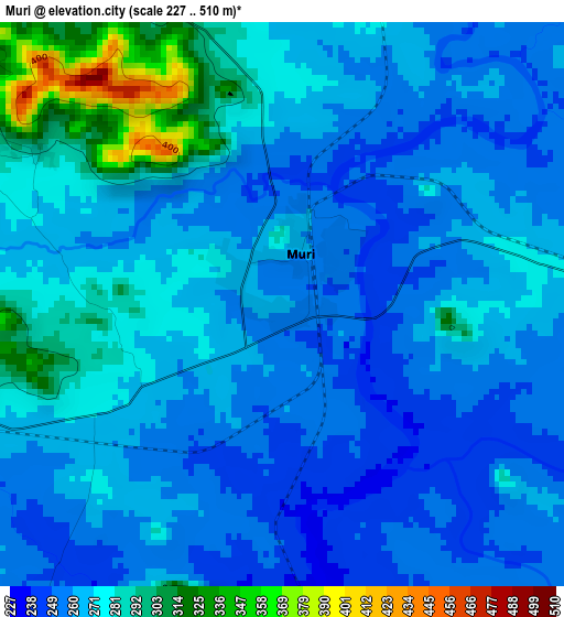
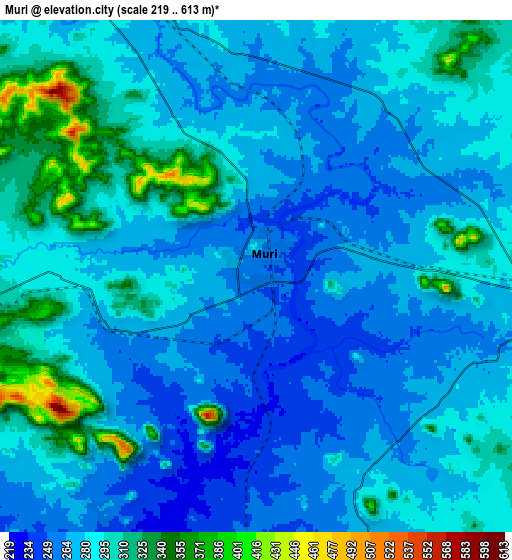
Below is the Elevation map of Muri, which displays elevation range with different colors. Scale of the first map is from 227 to 510 m (745 to 1673 ft) with average elevation of 268.5 meters (=881 ft) [note 1]
These maps also provides idea of topography and contour of this city, they are displayed at different zoom levels. More info about maps, scale and edge coordinates you can find below images.
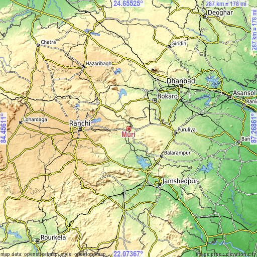
| \ | Map #1 | Map #2 | Topo.Map |
| Scale [m] | 227..510 m | 219..613 m | × |
| Scale [ft] | 745..1673 ft | 719..2011 ft | × |
| Average | 268.5 m = 881 ft | 283.2 m = 929 ft | × |
| Width | 8.97 km = 5.6 mi | 17.94 km = 11.1 mi | 287 km = 178.3 mi |
| Height | 8.97 km = 5.6 mi | 17.94 km = 11.1 mi | 287.1 km = 178.4 mi |
| ↑Max Latitude | 23.411074° | 23.451395° | 24.65525° |
| Latitude at center | 23.37074° | 23.37074° | 23.37074° |
| ↓Min Latitude | 23.330394° | 23.290036° | 22.07367° |
| ← Min Longitude | 85.818415° | 85.774469° | 84.45611° |
| Longitude center | 85.86236° | 85.86236° | 85.86236° |
| →Max Longitude | 85.906305° | 85.950251° | 87.26861° |
Nearby cities:
Cities around Muri sort by population:
• Bokāro elevation 242 m
47.3 km,  11°
11°
• Puruliya 255 m
51.3 km,  94°
94°
• Chās 217 m
42.8 km,  46°
46°
• Rāmgarh 339 m
45.2 km,  309°
309°
• Gumia 289 m
47.6 km,  355°
355°
• Balarāmpur 281 m
47.8 km,  129°
129°
• Dugda 213 m
52.2 km,  37°
37°
• Būndu 325 m
36.3 km,  230°
230°
• Barkā Kānā 354 m
49 km,  304°
304°
• Jhalidā 298 m
11.7 km, 92°
• Chāndil 182 m
49.9 km,  156°
156°
• Sāruberā 345 m
51.6 km,  15°
15°
Multilingual:
 En español:
Muri elevación 262 m.
 En France:
Muri élévation 262 m.


Sources and notes:
- [note 1] Map square and city borders are not equal. Map elevation data is calculated only from area inside that square.
- [src 1] Elevation data from geonames database provided with same terms of usage.
- [src 2] The elevation map of Muri is generated using elevation data from NASA's 3 arcsec (90m) resolution SRTM data.
- [src 3] Base (background) map © OpenStreetMap contributors tiles are generated by Geofabrik and OpenTopoMap.
Copyright & License:
This Muri Elevation Map is licensed under CC BY-SA. You may reuse any part from this page, if you give a proper credit by linking to this URL:
 More info on terms of use page.