Nāhan elevation
Nāhan (Himachal Pradesh, Sirmaur), India elevation is 909 meters and Nāhan elevation in feet is 2982 ft above sea level [src 1]. Nāhan is a populated place (feature code) with elevation that is 616 meters (2021 ft) bigger than average city elevation in India.
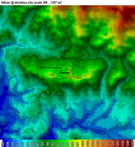
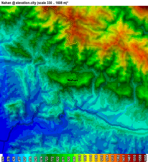
Below is the Elevation map of Nāhan, which displays elevation range with different colors. Scale of the first map is from 398 to 1397 m (1306 to 4583 ft) with average elevation of 702.3 meters (=2304 ft) [note 1]
These maps also provides idea of topography and contour of this city, they are displayed at different zoom levels. More info about maps, scale and edge coordinates you can find below images.
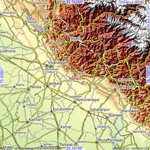
| \ | Map #1 | Map #2 | Topo.Map |
| Scale [m] | 398..1397 m | 330..1608 m | × |
| Scale [ft] | 1306..4583 ft | 1083..5276 ft | × |
| Average | 702.3 m = 2304 ft | 716.8 m = 2352 ft | × |
| Width | 8.42 km = 5.2 mi | 16.83 km = 10.5 mi | 269.3 km = 167.3 mi |
| Height | 8.42 km = 5.2 mi | 16.83 km = 10.5 mi | 269.3 km = 167.3 mi |
| ↑Max Latitude | 30.598124° | 30.635943° | 31.76359° |
| Latitude at center | 30.56029° | 30.56029° | 30.56029° |
| ↓Min Latitude | 30.522442° | 30.484578° | 29.34188° |
| ← Min Longitude | 77.250315° | 77.206369° | 75.88801° |
| Longitude center | 77.29426° | 77.29426° | 77.29426° |
| →Max Longitude | 77.338205° | 77.382151° | 78.70051° |
Nearby cities:
Cities around Nāhan sort by population:
• Jagādhri elevation 292 m
43.7 km,  178°
178°
• Solan 1509 m
42.6 km,  335°
335°
• Pinjaur 558 m
44.7 km,  306°
306°
• Pāonta Sāhib 403 m
34.5 km,  113°
113°
• Narāyangarh 332 m
18.4 km,  240°
240°
• Basi 306 m
43.1 km,  274°
274°
• Chhachhrauli 298 m
35.6 km,  169°
169°
• Bilāspur 306 m
28.5 km, 178°
• Mustafābād 284 m
42.2 km,  199°
199°
• Parwanoo 789 m
44.3 km, 314°
• Dagshai 1824 m
42.8 km,  327°
327°
• Rājgarh 1524 m
32.4 km,  1°
1°
Multilingual:
 En español:
Nāhan elevación 909 m.
 En France:
Nāhan élévation 909 m.


Sources and notes:
- [note 1] Map square and city borders are not equal. Map elevation data is calculated only from area inside that square.
- [src 1] Elevation data from geonames database provided with same terms of usage.
- [src 2] The elevation map of Nāhan is generated using elevation data from NASA's 3 arcsec (90m) resolution SRTM data.
- [src 3] Base (background) map © OpenStreetMap contributors tiles are generated by Geofabrik and OpenTopoMap.
Copyright & License:
This Nāhan Elevation Map is licensed under CC BY-SA. You may reuse any part from this page, if you give a proper credit by linking to this URL:
 More info on terms of use page.