Jagādhri elevation
Jagādhri (Haryana, Yamunanagar), India elevation is 292 meters and Jagādhri elevation in feet is 958 ft above sea level [src 1]. Jagādhri is a populated place (feature code) with elevation that is 1 meters (3 ft) smaller than average city elevation in India.
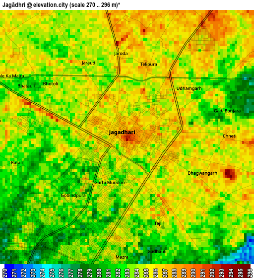
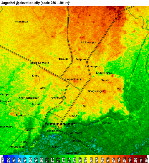
Below is the Elevation map of Jagādhri, which displays elevation range with different colors. Scale of the first map is from 270 to 296 m (886 to 971 ft) with average elevation of 283.8 meters (=931 ft) [note 1]
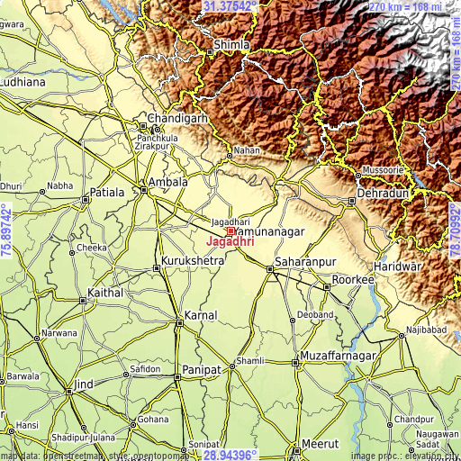
These maps also provides idea of topography and contour of this city, they are displayed at different zoom levels. More info about maps, scale and edge coordinates you can find below images.
| \ | Map #1 | Map #2 | Topo.Map |
| Scale [m] | 270..296 m | 256..301 m | × |
| Scale [ft] | 886..971 ft | 840..988 ft | × |
| Average | 283.8 m = 931 ft | 281 m = 922 ft | × |
| Width | 8.45 km = 5.3 mi | 16.9 km = 10.5 mi | 270.4 km = 168 mi |
| Height | 8.45 km = 5.3 mi | 16.9 km = 10.5 mi | 270.4 km = 168 mi |
| ↑Max Latitude | 30.205176° | 30.243148° | 31.37542° |
| Latitude at center | 30.16719° | 30.16719° | 30.16719° |
| ↓Min Latitude | 30.129189° | 30.091174° | 28.94396° |
| ← Min Longitude | 77.259725° | 77.215779° | 75.89742° |
| Longitude center | 77.30367° | 77.30367° | 77.30367° |
| →Max Longitude | 77.347615° | 77.391561° | 78.70992° |
Nearby cities:
Cities around Jagādhri sort by population:
• Sahāranpur elevation 280 m
32.1 km,  133°
133°
• Yamunānagar 278 m
4.8 km,  203°
203°
• Lādwa 266 m
31.5 km,  232°
232°
• Nakūr 272 m
27.5 km,  179°
179°
• Narāyangarh 332 m
38.4 km,  333°
333°
• Behat 306 m
29.8 km,  89°
89°
• Ambahta 269 m
34.6 km,  174°
174°
• Radaur 270 m
21.4 km,  223°
223°
• Chhachhrauli 298 m
10.2 km,  32°
32°
• Bilāspur 306 m
15.3 km,  0°
0°
• Būriya 286 m
5.3 km,  99°
99°
• Mustafābād 284 m
15.4 km,  284°
284°
Multilingual:
 En español:
Jagādhri elevación 292 m.
 En France:
Jagādhri élévation 292 m.
 Auf Deutsch:
Jagādhri höhe über dem Meeresspiegel ist 292 m.

Sources and notes:
- [note 1] Map square and city borders are not equal. Map elevation data is calculated only from area inside that square.
- [src 1] Elevation data from geonames database provided with same terms of usage.
- [src 2] The elevation map of Jagādhri is generated using elevation data from NASA's 3 arcsec (90m) resolution SRTM data.
- [src 3] Base (background) map © OpenStreetMap contributors tiles are generated by Geofabrik and OpenTopoMap.
Copyright & License:
This Jagādhri Elevation Map is licensed under CC BY-SA. You may reuse any part from this page, if you give a proper credit by linking to this URL:
 More info on terms of use page.