Nangal elevation
Nangal (Punjab, Rupnagar), India elevation is 364 meters and Nangal elevation in feet is 1194 ft above sea level [src 1]. Nangal is a populated place (feature code) with elevation that is 71 meters (233 ft) bigger than average city elevation in India.
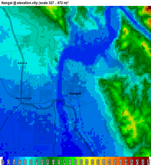
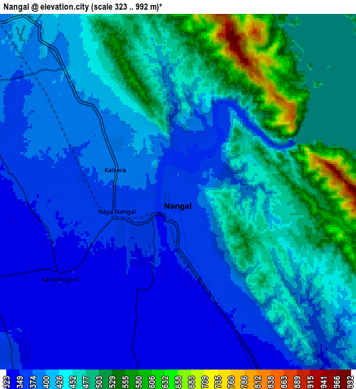
Below is the Elevation map of Nangal, which displays elevation range with different colors. Scale of the first map is from 327 to 672 m (1073 to 2205 ft) with average elevation of 387.5 meters (=1271 ft) [note 1]
These maps also provides idea of topography and contour of this city, they are displayed at different zoom levels. More info about maps, scale and edge coordinates you can find below images.
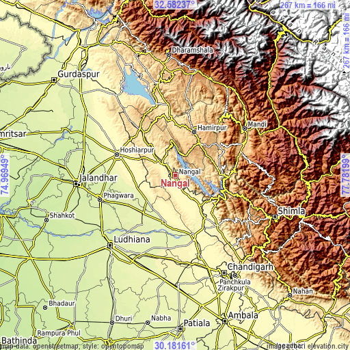
| \ | Map #1 | Map #2 | Topo.Map |
| Scale [m] | 327..672 m | 323..992 m | × |
| Scale [ft] | 1073..2205 ft | 1060..3255 ft | × |
| Average | 387.5 m = 1271 ft | 423.2 m = 1388 ft | × |
| Width | 8.34 km = 5.2 mi | 16.68 km = 10.4 mi | 266.9 km = 165.8 mi |
| Height | 8.34 km = 5.2 mi | 16.68 km = 10.4 mi | 266.9 km = 165.8 mi |
| ↑Max Latitude | 31.427166° | 31.464657° | 32.58237° |
| Latitude at center | 31.38966° | 31.38966° | 31.38966° |
| ↓Min Latitude | 31.352139° | 31.314603° | 30.18161° |
| ← Min Longitude | 76.331795° | 76.287849° | 74.96949° |
| Longitude center | 76.37574° | 76.37574° | 76.37574° |
| →Max Longitude | 76.419685° | 76.463631° | 77.78199° |
Nearby cities:
Cities around Nangal sort by population:
• Nawanshahr elevation 264 m
38.4 km,  219°
219°
• Hamīrpur 768 m
35.7 km,  23°
23°
• Banga 256 m
42.5 km,  238°
238°
• Bālāchor 277 m
37.3 km,  190°
190°
• Una 395 m
13.1 km,  309°
309°
• Garhshankar 273 m
29.5 km,  228°
228°
• Anandpur 309 m
20.6 km,  144°
144°
• Bilaspur 496 m
36.8 km,  100°
100°
• Nūrpur Kalān 299 m
26.8 km,  157°
157°
• Santokhgarh 348 m
6.9 km, 232°
• Ghumārwīn 644 m
32.7 km,  79°
79°
• Gagret 470 m
42.2 km,  315°
315°
Multilingual:
 En español:
Nangal elevación 364 m.
 En France:
Nangal élévation 364 m.


Sources and notes:
- [note 1] Map square and city borders are not equal. Map elevation data is calculated only from area inside that square.
- [src 1] Elevation data from geonames database provided with same terms of usage.
- [src 2] The elevation map of Nangal is generated using elevation data from NASA's 3 arcsec (90m) resolution SRTM data.
- [src 3] Base (background) map © OpenStreetMap contributors tiles are generated by Geofabrik and OpenTopoMap.
Copyright & License:
This Nangal Elevation Map is licensed under CC BY-SA. You may reuse any part from this page, if you give a proper credit by linking to this URL:
 More info on terms of use page.