Hamīrpur elevation
Hamīrpur (Himachal Pradesh), India elevation is 768 meters and Hamīrpur elevation in feet is 2520 ft above sea level [src 1]. Hamīrpur is a populated place (feature code) with elevation that is 475 meters (1558 ft) bigger than average city elevation in India.
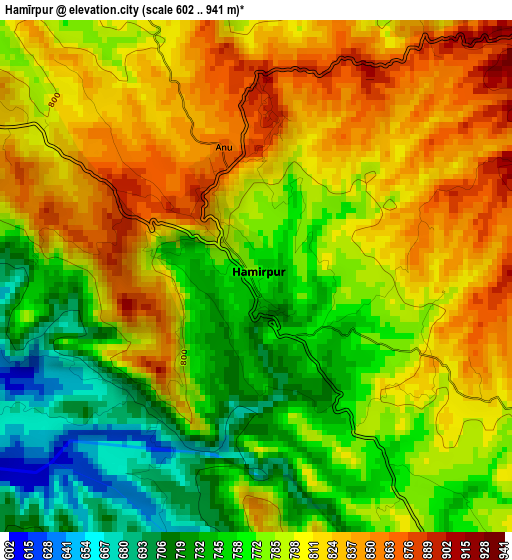
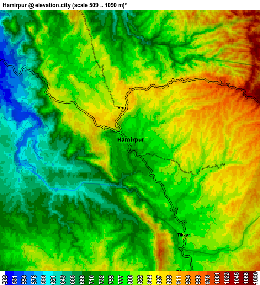
Below is the Elevation map of Hamīrpur, which displays elevation range with different colors. Scale of the first map is from 602 to 941 m (1975 to 3087 ft) with average elevation of 789 meters (=2589 ft) [note 1]
These maps also provides idea of topography and contour of this city, they are displayed at different zoom levels. More info about maps, scale and edge coordinates you can find below images.
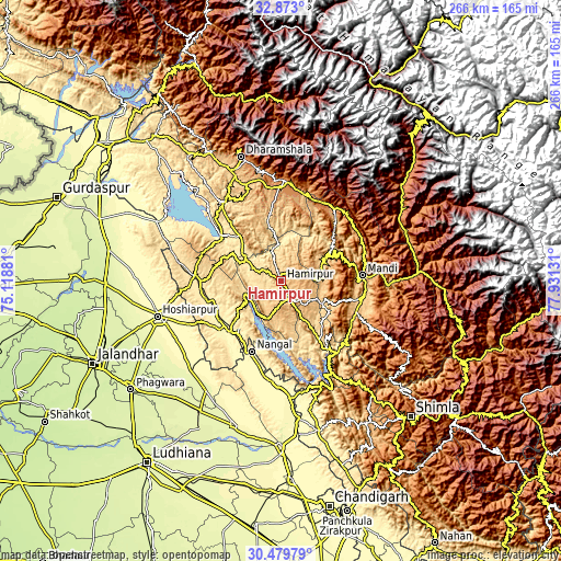
| \ | Map #1 | Map #2 | Topo.Map |
| Scale [m] | 602..941 m | 509..1090 m | × |
| Scale [ft] | 1975..3087 ft | 1670..3576 ft | × |
| Average | 789 m = 2589 ft | 784.1 m = 2573 ft | × |
| Width | 8.32 km = 5.2 mi | 16.63 km = 10.3 mi | 266.1 km = 165.3 mi |
| Height | 8.32 km = 5.2 mi | 16.63 km = 10.3 mi | 266.1 km = 165.3 mi |
| ↑Max Latitude | 31.721498° | 31.758871° | 32.873° |
| Latitude at center | 31.68411° | 31.68411° | 31.68411° |
| ↓Min Latitude | 31.646707° | 31.609289° | 30.47979° |
| ← Min Longitude | 76.481115° | 76.437169° | 75.11881° |
| Longitude center | 76.52506° | 76.52506° | 76.52506° |
| →Max Longitude | 76.569005° | 76.612951° | 77.93131° |
Nearby cities:
Cities around Hamīrpur sort by population:
• Nangal elevation 364 m
35.7 km,  203°
203°
• Mandi 764 m
38.7 km,  85°
85°
• Sundarnagar 884 m
39.6 km,  114°
114°
• Una 395 m
34.4 km,  224°
224°
• Santokhgarh 348 m
41.8 km,  208°
208°
• Tīra Sujānpur 565 m
16.7 km,  353°
353°
• Ghumārwīn 644 m
32.4 km,  146°
146°
• Jawāla Mukhi 520 m
28.7 km,  317°
317°
• Jogindarnagar 1175 m
41.9 km,  36°
36°
• Nādaun 478 m
20.4 km,  302°
302°
• Dera Gopipur 445 m
36.2 km,  306°
306°
• Sarka Ghāt 958 m
20 km, 85°
Multilingual:
 En español:
Hamīrpur elevación 768 m.
 En France:
Hamīrpur élévation 768 m.
 Auf Deutsch:
Hamīrpur höhe über dem Meeresspiegel ist 768 m.

Sources and notes:
- [note 1] Map square and city borders are not equal. Map elevation data is calculated only from area inside that square.
- [src 1] Elevation data from geonames database provided with same terms of usage.
- [src 2] The elevation map of Hamīrpur is generated using elevation data from NASA's 3 arcsec (90m) resolution SRTM data.
- [src 3] Base (background) map © OpenStreetMap contributors tiles are generated by Geofabrik and OpenTopoMap.
Copyright & License:
This Hamīrpur Elevation Map is licensed under CC BY-SA. You may reuse any part from this page, if you give a proper credit by linking to this URL:
 More info on terms of use page.