Nawanshahr elevation
Nawanshahr (Punjab, Shahid Bhagat Singh Nagar), India elevation is 264 meters and Nawanshahr elevation in feet is 866 ft above sea level [src 1]. Nawanshahr is a populated place (feature code) with elevation that is 29 meters (95 ft) smaller than average city elevation in India.
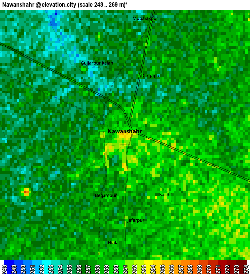
Below is the Elevation map of Nawanshahr, which displays elevation range with different colors. Scale of the first map is from 248 to 269 m (814 to 883 ft) with average elevation of 256.9 meters (=843 ft) [note 1]
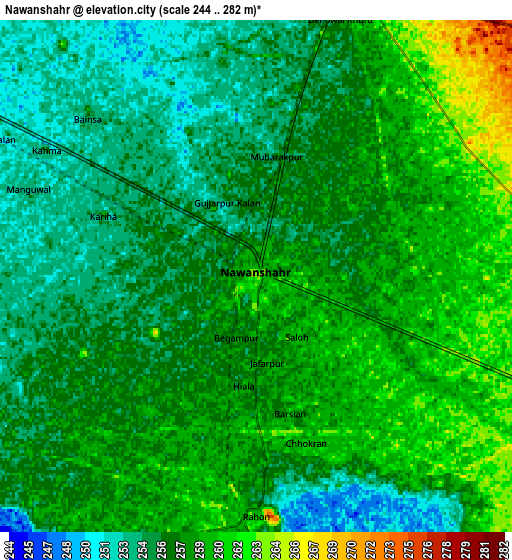
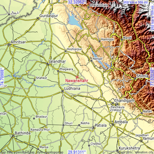
These maps also provides idea of topography and contour of this city, they are displayed at different zoom levels. More info about maps, scale and edge coordinates you can find below images.
| \ | Map #1 | Map #2 | Topo.Map |
| Scale [m] | 248..269 m | 244..282 m | × |
| Scale [ft] | 814..883 ft | 801..925 ft | × |
| Average | 256.9 m = 843 ft | 257 m = 843 ft | × |
| Width | 8.37 km = 5.2 mi | 16.73 km = 10.4 mi | 267.7 km = 166.3 mi |
| Height | 8.37 km = 5.2 mi | 16.73 km = 10.4 mi | 267.7 km = 166.3 mi |
| ↑Max Latitude | 31.162112° | 31.199709° | 32.32062° |
| Latitude at center | 31.1245° | 31.1245° | 31.1245° |
| ↓Min Latitude | 31.086873° | 31.049232° | 29.91311° |
| ← Min Longitude | 76.072185° | 76.028239° | 74.70988° |
| Longitude center | 76.11613° | 76.11613° | 76.11613° |
| →Max Longitude | 76.160075° | 76.204021° | 77.52238° |
Nearby cities:
Cities around Nawanshahr sort by population:
• Ludhiāna elevation 256 m
34.4 km,  226°
226°
• Phagwāra 248 m
34.4 km,  288°
288°
• Dorāha 262 m
37.2 km,  193°
193°
• Phillaur 246 m
33.1 km,  249°
249°
• Māchhīwāra 261 m
24.6 km,  160°
160°
• Banga 256 m
13.6 km,  301°
301°
• Bālāchor 277 m
19 km,  111°
111°
• Samrāla 271 m
32.9 km,  167°
167°
• Garhshankar 273 m
10.4 km,  13°
13°
• Rāhon 263 m
8 km,  177°
177°
• Nūrpur Kalān 299 m
35.3 km,  82°
82°
• Santokhgarh 348 m
31.7 km,  37°
37°
Multilingual:
 En español:
Nawanshahr elevación 264 m.
 En France:
Nawanshahr élévation 264 m.
 Auf Deutsch:
Nawanshahr höhe über dem Meeresspiegel ist 264 m.

Sources and notes:
- [note 1] Map square and city borders are not equal. Map elevation data is calculated only from area inside that square.
- [src 1] Elevation data from geonames database provided with same terms of usage.
- [src 2] The elevation map of Nawanshahr is generated using elevation data from NASA's 3 arcsec (90m) resolution SRTM data.
- [src 3] Base (background) map © OpenStreetMap contributors tiles are generated by Geofabrik and OpenTopoMap.
Copyright & License:
This Nawanshahr Elevation Map is licensed under CC BY-SA. You may reuse any part from this page, if you give a proper credit by linking to this URL:
 More info on terms of use page.