Nyāmti elevation
Nyāmti (Karnataka, Davanagere), India elevation is 605 meters and Nyāmti elevation in feet is 1985 ft above sea level [src 1]. Nyāmti is a populated place (feature code) with elevation that is 312 meters (1024 ft) bigger than average city elevation in India.
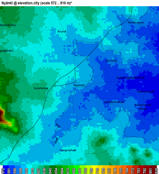
Below is the Elevation map of Nyāmti, which displays elevation range with different colors. Scale of the first map is from 572 to 810 m (1877 to 2657 ft) with average elevation of 610.1 meters (=2002 ft) [note 1]
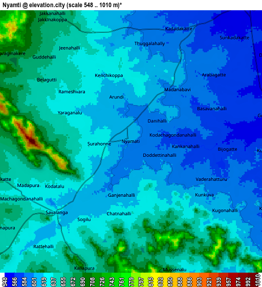
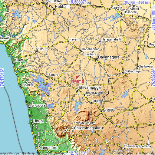
These maps also provides idea of topography and contour of this city, they are displayed at different zoom levels. More info about maps, scale and edge coordinates you can find below images.
| \ | Map #1 | Map #2 | Topo.Map |
| Scale [m] | 572..810 m | 548..1010 m | × |
| Scale [ft] | 1877..2657 ft | 1798..3314 ft | × |
| Average | 610.1 m = 2002 ft | 629 m = 2064 ft | × |
| Width | 9.48 km = 5.9 mi | 18.95 km = 11.8 mi | 303.2 km = 188.4 mi |
| Height | 9.48 km = 5.9 mi | 18.95 km = 11.8 mi | 303.2 km = 188.4 mi |
| ↑Max Latitude | 14.191298° | 14.233898° | 15.50807° |
| Latitude at center | 14.14869° | 14.14869° | 14.14869° |
| ↓Min Latitude | 14.106074° | 14.06345° | 12.78113° |
| ← Min Longitude | 75.532465° | 75.488519° | 74.17016° |
| Longitude center | 75.57641° | 75.57641° | 75.57641° |
| →Max Longitude | 75.620355° | 75.664301° | 76.98266° |
Nearby cities:
Cities around Nyāmti sort by population:
• Davangere elevation 592 m
51.8 km,  46°
46°
• Shimoga 590 m
24.2 km,  182°
182°
• Bhadrāvati 592 m
36.2 km,  157°
157°
• Rānībennur 579 m
53 km,  6°
6°
• Harihar 546 m
47.5 km,  31°
31°
• Tarikere 685 m
55.1 km,  152°
152°
• Shikārpur 615 m
27.3 km,  299°
299°
• Channagiri 691 m
40.1 km,  110°
110°
• Honnāli 562 m
12.5 km,  36°
36°
• Hirekerūr 611 m
39.3 km,  330°
330°
• Beltangadi 652 m
35 km,  238°
238°
• Kumsi 667 m
21.7 km, 241°
Multilingual:
 En español:
Nyāmti elevación 605 m.
 En France:
Nyāmti élévation 605 m.


Sources and notes:
- [note 1] Map square and city borders are not equal. Map elevation data is calculated only from area inside that square.
- [src 1] Elevation data from geonames database provided with same terms of usage.
- [src 2] The elevation map of Nyāmti is generated using elevation data from NASA's 3 arcsec (90m) resolution SRTM data.
- [src 3] Base (background) map © OpenStreetMap contributors tiles are generated by Geofabrik and OpenTopoMap.
Copyright & License:
This Nyāmti Elevation Map is licensed under CC BY-SA. You may reuse any part from this page, if you give a proper credit by linking to this URL:
 More info on terms of use page.