Rānībennur elevation
Rānībennur (Karnataka, Haveri), India elevation is 579 meters and Rānībennur elevation in feet is 1900 ft above sea level [src 1]. Rānībennur is a populated place (feature code) with elevation that is 286 meters (938 ft) bigger than average city elevation in India.
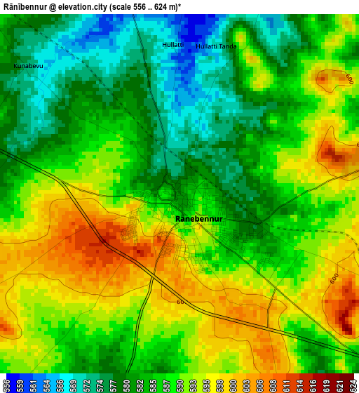
Below is the Elevation map of Rānībennur, which displays elevation range with different colors. Scale of the first map is from 556 to 624 m (1824 to 2047 ft) with average elevation of 587.4 meters (=1927 ft) [note 1]
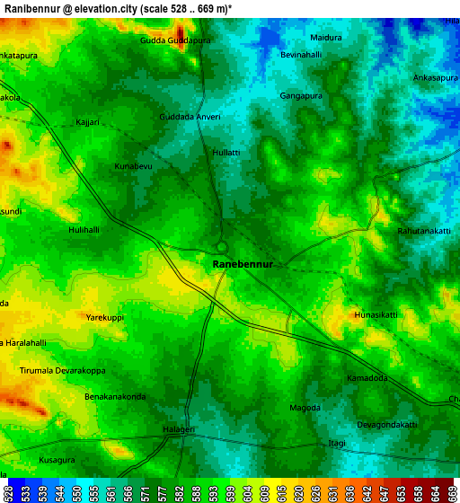
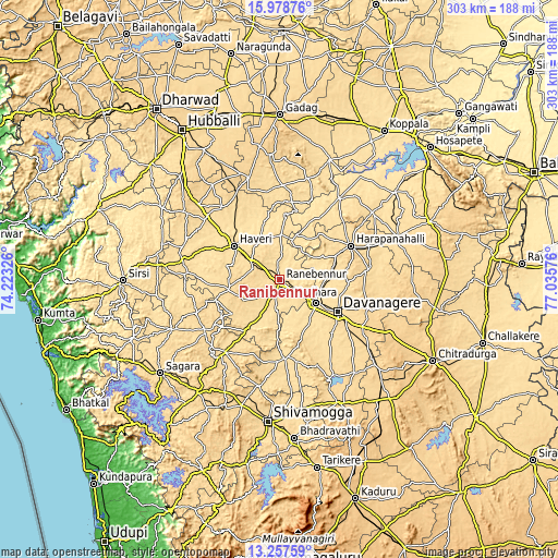
These maps also provides idea of topography and contour of this city, they are displayed at different zoom levels. More info about maps, scale and edge coordinates you can find below images.
| \ | Map #1 | Map #2 | Topo.Map |
| Scale [m] | 556..624 m | 528..669 m | × |
| Scale [ft] | 1824..2047 ft | 1732..2195 ft | × |
| Average | 587.4 m = 1927 ft | 582.6 m = 1911 ft | × |
| Width | 9.46 km = 5.9 mi | 18.91 km = 11.8 mi | 302.6 km = 188 mi |
| Height | 9.46 km = 5.9 mi | 18.91 km = 11.8 mi | 302.6 km = 188 mi |
| ↑Max Latitude | 14.664908° | 14.707417° | 15.97876° |
| Latitude at center | 14.62239° | 14.62239° | 14.62239° |
| ↓Min Latitude | 14.579864° | 14.53733° | 13.25759° |
| ← Min Longitude | 75.585565° | 75.541619° | 74.22326° |
| Longitude center | 75.62951° | 75.62951° | 75.62951° |
| →Max Longitude | 75.673455° | 75.717401° | 77.03576° |
Nearby cities:
Cities around Rānībennur sort by population:
• Davangere elevation 592 m
36.4 km,  118°
118°
• Harihar 546 m
22.7 km, 122°
• Hāveri 576 m
30.8 km,  308°
308°
• Harpanahalli 624 m
42.8 km,  64°
64°
• Savanūr 590 m
50.1 km,  321°
321°
• Shikārpur 615 m
49 km,  216°
216°
• Byādgi 613 m
16.4 km,  290°
290°
• Hāngal 586 m
56.6 km, 286°
• Hadagalli 524 m
54.9 km,  36°
36°
• Honnāli 562 m
42.6 km,  177°
177°
• Hirekerūr 611 m
31.3 km,  233°
233°
• Nyāmti 605 m
53 km,  186°
186°
Multilingual:
 En español:
Rānībennur elevación 579 m.
 En France:
Rānībennur élévation 579 m.
 Auf Deutsch:
Rānībennur höhe über dem Meeresspiegel ist 579 m.

Sources and notes:
- [note 1] Map square and city borders are not equal. Map elevation data is calculated only from area inside that square.
- [src 1] Elevation data from geonames database provided with same terms of usage.
- [src 2] The elevation map of Rānībennur is generated using elevation data from NASA's 3 arcsec (90m) resolution SRTM data.
- [src 3] Base (background) map © OpenStreetMap contributors tiles are generated by Geofabrik and OpenTopoMap.
Copyright & License:
This Rānībennur Elevation Map is licensed under CC BY-SA. You may reuse any part from this page, if you give a proper credit by linking to this URL:
 More info on terms of use page.