Rāmnagar elevation
Rāmnagar (Bihar, Pashchim Champāran), India elevation is 100 meters and Rāmnagar elevation in feet is 328 ft above sea level [src 1]. Rāmnagar is a populated place (feature code) with elevation that is 193 meters (633 ft) smaller than average city elevation in India.
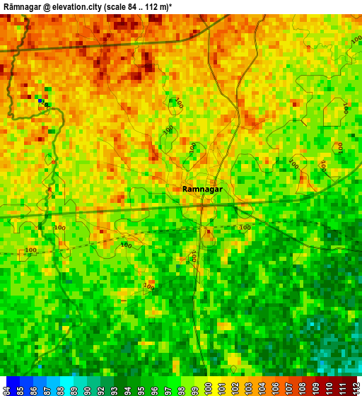
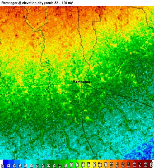
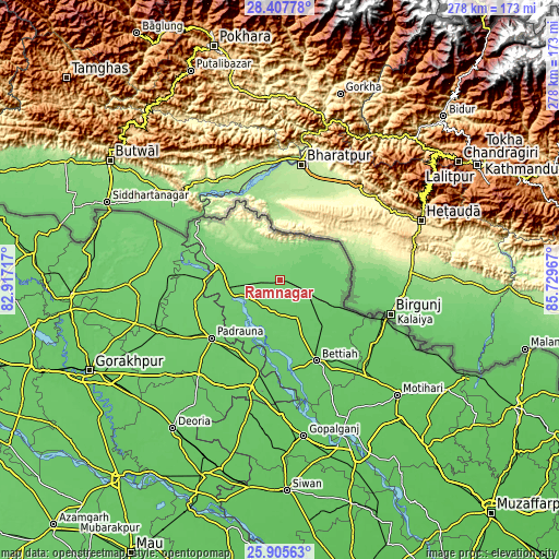
Below is the Elevation map of Rāmnagar, which displays elevation range with different colors. Scale of the first map is from 84 to 112 m (276 to 367 ft) with average elevation of 99.2 meters (=325 ft) [note 1]
These maps also provides idea of topography and contour of this city, they are displayed at different zoom levels. More info about maps, scale and edge coordinates you can find below images.
| \ | Map #1 | Map #2 | Topo.Map |
| Scale [m] | 84..112 m | 82..120 m | × |
| Scale [ft] | 276..367 ft | 269..394 ft | × |
| Average | 99.2 m = 325 ft | 98.9 m = 324 ft | × |
| Width | 8.69 km = 5.4 mi | 17.39 km = 10.8 mi | 278.2 km = 172.9 mi |
| Height | 8.69 km = 5.4 mi | 17.39 km = 10.8 mi | 278.2 km = 172.9 mi |
| ↑Max Latitude | 27.202802° | 27.241879° | 28.40778° |
| Latitude at center | 27.16371° | 27.16371° | 27.16371° |
| ↓Min Latitude | 27.124605° | 27.085486° | 25.90563° |
| ← Min Longitude | 84.279475° | 84.235529° | 82.91717° |
| Longitude center | 84.32342° | 84.32342° | 84.32342° |
| →Max Longitude | 84.367365° | 84.411311° | 85.72967° |
Nearby cities:
Cities around Rāmnagar sort by population:
• Bettiah elevation 84 m
44 km,  156°
156°
• Bagaha 94 m
24.2 km,  252°
252°
• Raxaul 86 m
56.1 km,  111°
111°
• Padrauna 94 m
44.5 km,  229°
229°
• Sagauli 75 m
60.9 km,  136°
136°
• Mahārāganj 96 m
75.3 km,  268°
268°
• Siswā Bāzār 100 m
56 km, 268°
• Nichlaul 104 m
61.4 km,  285°
285°
• Khada 96 m
43.6 km, 272°
• Rāmkola 90 m
56.2 km,  238°
238°
• Captainganj 94 m
65.9 km, 246°
• Hātā 83 m
74.1 km, 230°
Multilingual:
 En español:
Rāmnagar elevación 100 m.
 En France:
Rāmnagar élévation 100 m.
 Auf Deutsch:
Rāmnagar höhe über dem Meeresspiegel ist 100 m.

Sources and notes:
- [note 1] Map square and city borders are not equal. Map elevation data is calculated only from area inside that square.
- [src 1] Elevation data from geonames database provided with same terms of usage.
- [src 2] The elevation map of Rāmnagar is generated using elevation data from NASA's 3 arcsec (90m) resolution SRTM data.
- [src 3] Base (background) map © OpenStreetMap contributors tiles are generated by Geofabrik and OpenTopoMap.
Copyright & License:
This Rāmnagar Elevation Map is licensed under CC BY-SA. You may reuse any part from this page, if you give a proper credit by linking to this URL:
 More info on terms of use page.