Rāpar elevation
Rāpar (Gujarat, Kachchh), India elevation is 65 meters and Rāpar elevation in feet is 213 ft above sea level [src 1]. Rāpar is a populated place (feature code) with elevation that is 228 meters (748 ft) smaller than average city elevation in India.
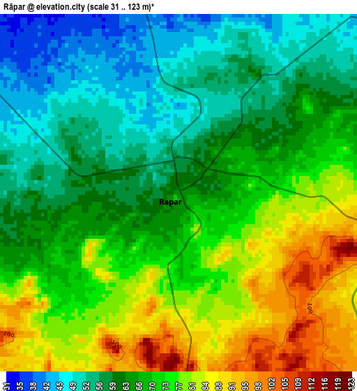
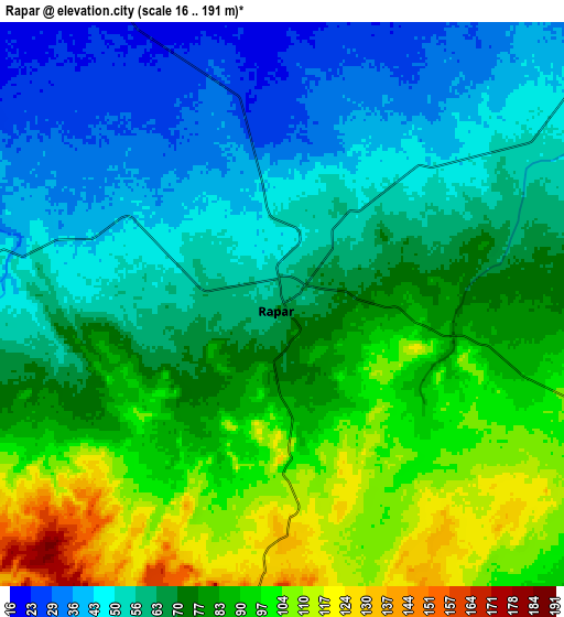
Below is the Elevation map of Rāpar, which displays elevation range with different colors. Scale of the first map is from 31 to 123 m (102 to 404 ft) with average elevation of 67.8 meters (=222 ft) [note 1]
These maps also provides idea of topography and contour of this city, they are displayed at different zoom levels. More info about maps, scale and edge coordinates you can find below images.
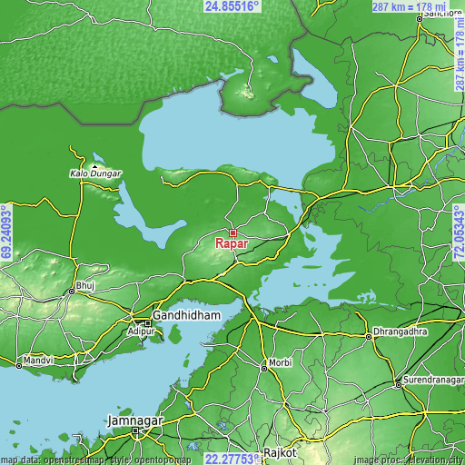
| \ | Map #1 | Map #2 | Topo.Map |
| Scale [m] | 31..123 m | 16..191 m | × |
| Scale [ft] | 102..404 ft | 52..627 ft | × |
| Average | 67.8 m = 222 ft | 71.7 m = 235 ft | × |
| Width | 8.96 km = 5.6 mi | 17.91 km = 11.1 mi | 286.6 km = 178.1 mi |
| Height | 8.96 km = 5.6 mi | 17.91 km = 11.1 mi | 286.6 km = 178.1 mi |
| ↑Max Latitude | 23.612942° | 23.653202° | 24.85516° |
| Latitude at center | 23.57267° | 23.57267° | 23.57267° |
| ↓Min Latitude | 23.532386° | 23.492089° | 22.27753° |
| ← Min Longitude | 70.603235° | 70.559289° | 69.24093° |
| Longitude center | 70.64718° | 70.64718° | 70.64718° |
| →Max Longitude | 70.691125° | 70.735071° | 72.05343° |
Nearby cities:
Cities around Rāpar sort by population:
• Gāndhīdhām elevation 21 m
75.6 km,  223°
223°
• Bhuj 106 m
105.9 km,  250°
250°
• Morbi 53 m
86.2 km,  166°
166°
• Dhrāngadhra 51 m
105.8 km,  127°
127°
• Anjār 69 m
81.4 km,  231°
231°
• Wānkāner 85 m
111 km,  164°
164°
• Rādhanpur 35 m
101.7 km,  73°
73°
• Halvad 45 m
82.5 km,  138°
138°
• Kāndla 8 m
74.4 km, 216°
• Bhachāu 44 m
43.5 km, 225°
• Jodiya Bandar 2 m
102.2 km,  201°
201°
• Tankāra 64 m
102.4 km, 174°
Multilingual:
 En español:
Rāpar elevación 65 m.
 En France:
Rāpar élévation 65 m.


Sources and notes:
- [note 1] Map square and city borders are not equal. Map elevation data is calculated only from area inside that square.
- [src 1] Elevation data from geonames database provided with same terms of usage.
- [src 2] The elevation map of Rāpar is generated using elevation data from NASA's 3 arcsec (90m) resolution SRTM data.
- [src 3] Base (background) map © OpenStreetMap contributors tiles are generated by Geofabrik and OpenTopoMap.
Copyright & License:
This Rāpar Elevation Map is licensed under CC BY-SA. You may reuse any part from this page, if you give a proper credit by linking to this URL:
 More info on terms of use page.