Anjār elevation
Anjār (Gujarat, Kachchh), India elevation is 69 meters and Anjār elevation in feet is 226 ft above sea level [src 1]. Anjār is a populated place (feature code) with elevation that is 224 meters (735 ft) smaller than average city elevation in India.
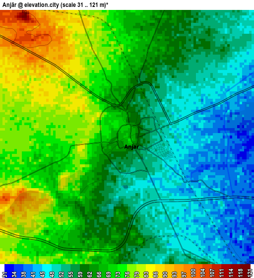
Below is the Elevation map of Anjār, which displays elevation range with different colors. Scale of the first map is from 31 to 121 m (102 to 397 ft) with average elevation of 63.4 meters (=208 ft) [note 1]
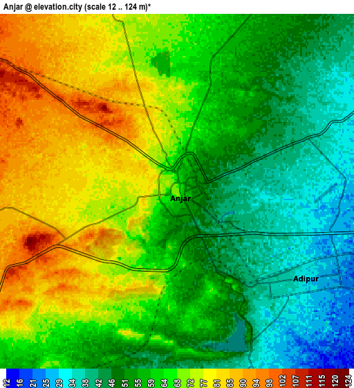
These maps also provides idea of topography and contour of this city, they are displayed at different zoom levels. More info about maps, scale and edge coordinates you can find below images.
| \ | Map #1 | Map #2 | Topo.Map |
| Scale [m] | 31..121 m | 12..124 m | × |
| Scale [ft] | 102..397 ft | 39..407 ft | × |
| Average | 63.4 m = 208 ft | 61.5 m = 202 ft | × |
| Width | 8.99 km = 5.6 mi | 17.98 km = 11.2 mi | 287.6 km = 178.7 mi |
| Height | 8.99 km = 5.6 mi | 17.98 km = 11.2 mi | 287.6 km = 178.7 mi |
| ↑Max Latitude | 23.153572° | 23.193971° | 24.40021° |
| Latitude at center | 23.11316° | 23.11316° | 23.11316° |
| ↓Min Latitude | 23.072736° | 23.0323° | 21.81365° |
| ← Min Longitude | 69.982765° | 69.938819° | 68.62046° |
| Longitude center | 70.02671° | 70.02671° | 70.02671° |
| →Max Longitude | 70.070655° | 70.114601° | 71.43296° |
Nearby cities:
Cities around Anjār sort by population:
• Jamnagar elevation 18 m
71.3 km,  176°
176°
• Gāndhīdhām 21 m
11.4 km,  106°
106°
• Bhuj 106 m
39.7 km,  293°
293°
• Māndvi 11 m
75.7 km,  245°
245°
• Dhrol 34 m
72.8 km,  146°
146°
• Kāndla 8 m
21.4 km, 114°
• Bhachāu 44 m
38.3 km,  57°
57°
• Bedi 9 m
68 km, 178°
• Sikka 13 m
78.1 km,  194°
194°
• Jodiya Bandar 2 m
51.3 km, 149°
• Mundra 18 m
43.6 km,  225°
225°
• Roha 175 m
77.8 km,  276°
276°
Multilingual:
 En español:
Anjār elevación 69 m.
 En France:
Anjār élévation 69 m.


Sources and notes:
- [note 1] Map square and city borders are not equal. Map elevation data is calculated only from area inside that square.
- [src 1] Elevation data from geonames database provided with same terms of usage.
- [src 2] The elevation map of Anjār is generated using elevation data from NASA's 3 arcsec (90m) resolution SRTM data.
- [src 3] Base (background) map © OpenStreetMap contributors tiles are generated by Geofabrik and OpenTopoMap.
Copyright & License:
This Anjār Elevation Map is licensed under CC BY-SA. You may reuse any part from this page, if you give a proper credit by linking to this URL:
 More info on terms of use page.