Wānkāner elevation
Wānkāner (Gujarat, Rājkot), India elevation is 85 meters and Wānkāner elevation in feet is 279 ft above sea level [src 1]. Wānkāner is a populated place (feature code) with elevation that is 208 meters (682 ft) smaller than average city elevation in India.
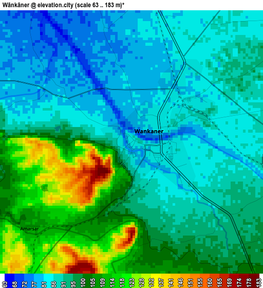
Below is the Elevation map of Wānkāner, which displays elevation range with different colors. Scale of the first map is from 63 to 183 m (207 to 600 ft) with average elevation of 95 meters (=312 ft) [note 1]
These maps also provides idea of topography and contour of this city, they are displayed at different zoom levels. More info about maps, scale and edge coordinates you can find below images.
| \ | Map #1 | Map #2 | Topo.Map |
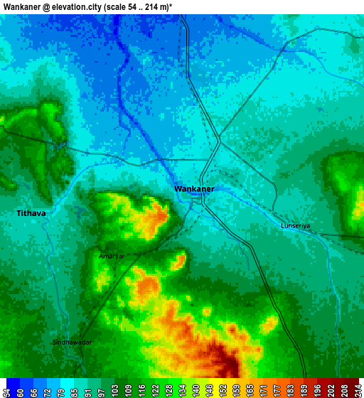
| Scale [m] | 63..183 m | 54..214 m | × |
| Scale [ft] | 207..600 ft | 177..702 ft | × |
| Average | 95 m = 312 ft | 97.6 m = 320 ft | × |
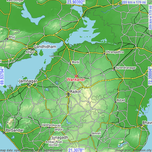
| Width | 9.02 km = 5.6 mi | 18.04 km = 11.2 mi | 288.7 km = 179.4 mi |
| Height | 9.02 km = 5.6 mi | 18.04 km = 11.2 mi | 288.7 km = 179.4 mi |
| ↑Max Latitude | 22.652541° | 22.693091° | 23.90392° |
| Latitude at center | 22.61198° | 22.61198° | 22.61198° |
| ↓Min Latitude | 22.571407° | 22.530822° | 21.3078° |
| ← Min Longitude | 70.899845° | 70.855899° | 69.53754° |
| Longitude center | 70.94379° | 70.94379° | 70.94379° |
| →Max Longitude | 70.987735° | 71.031681° | 72.35004° |
Nearby cities:
Cities around Wānkāner sort by population:
• Rājkot elevation 140 m
38.8 km,  203°
203°
• Morbi 53 m
25.3 km,  334°
334°
• Dhrāngadhra 51 m
68.3 km,  51°
51°
• Thān 144 m
26.6 km,  99°
99°
• Dhrol 34 m
54.2 km,  264°
264°
• Halvad 45 m
51 km,  28°
28°
• Sāyla 135 m
55.8 km, 97°
• Chotila 210 m
33.4 km,  128°
128°
• Shāhpur 182 m
53.7 km, 199°
• Vinchia 175 m
63.3 km, 134°
• Tankāra 64 m
20.5 km,  283°
283°
• Paddhari 68 m
40.2 km,  240°
240°
Multilingual:
 En español:
Wānkāner elevación 85 m.
 En France:
Wānkāner élévation 85 m.


Sources and notes:
- [note 1] Map square and city borders are not equal. Map elevation data is calculated only from area inside that square.
- [src 1] Elevation data from geonames database provided with same terms of usage.
- [src 2] The elevation map of Wānkāner is generated using elevation data from NASA's 3 arcsec (90m) resolution SRTM data.
- [src 3] Base (background) map © OpenStreetMap contributors tiles are generated by Geofabrik and OpenTopoMap.
Copyright & License:
This Wānkāner Elevation Map is licensed under CC BY-SA. You may reuse any part from this page, if you give a proper credit by linking to this URL:
 More info on terms of use page.