Sanāwad elevation
Sanāwad (Madhya Pradesh, Khargone), India elevation is 197 meters and Sanāwad elevation in feet is 646 ft above sea level [src 1]. Sanāwad is a populated place (feature code) with elevation that is 96 meters (315 ft) smaller than average city elevation in India.
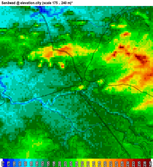
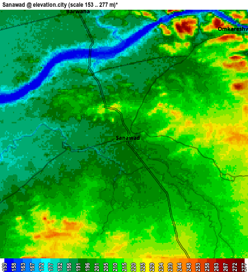
Below is the Elevation map of Sanāwad, which displays elevation range with different colors. Scale of the first map is from 175 to 240 m (574 to 787 ft) with average elevation of 198.3 meters (=651 ft) [note 1]
These maps also provides idea of topography and contour of this city, they are displayed at different zoom levels. More info about maps, scale and edge coordinates you can find below images.
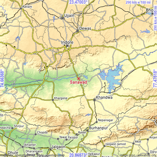
| \ | Map #1 | Map #2 | Topo.Map |
| Scale [m] | 175..240 m | 153..277 m | × |
| Scale [ft] | 574..787 ft | 502..909 ft | × |
| Average | 198.3 m = 651 ft | 200.9 m = 659 ft | × |
| Width | 9.05 km = 5.6 mi | 18.1 km = 11.2 mi | 289.6 km = 179.9 mi |
| Height | 9.05 km = 5.6 mi | 18.1 km = 11.2 mi | 289.6 km = 179.9 mi |
| ↑Max Latitude | 22.214599° | 22.255277° | 23.47003° |
| Latitude at center | 22.17391° | 22.17391° | 22.17391° |
| ↓Min Latitude | 22.133209° | 22.092496° | 20.86573° |
| ← Min Longitude | 76.025985° | 75.982039° | 74.66368° |
| Longitude center | 76.06993° | 76.06993° | 76.06993° |
| →Max Longitude | 76.113875° | 76.157821° | 77.47618° |
Nearby cities:
Cities around Sanāwad sort by population:
• Punāsa elevation 278 m
34 km,  78°
78°
• Khandwa 314 m
48.5 km,  143°
143°
• Khargone 258 m
61.1 km,  230°
230°
• Pithampur 595 m
61.2 km,  321°
321°
• Maheshwar 161 m
49.7 km,  270°
270°
• Kasrāwad 182 m
47.5 km,  263°
263°
• Bhikangaon 283 m
35.8 km,  197°
197°
• Māndleshwar 165 m
42.2 km, 270°
• Pandhāna 364 m
55.3 km,  163°
163°
• Mundi 304 m
45.2 km,  105°
105°
• Bāgli 553 m
59.3 km,  28°
28°
• Mānpur 577 m
54.3 km,  301°
301°
Multilingual:
 En español:
Sanāwad elevación 197 m.
 En France:
Sanāwad élévation 197 m.


Sources and notes:
- [note 1] Map square and city borders are not equal. Map elevation data is calculated only from area inside that square.
- [src 1] Elevation data from geonames database provided with same terms of usage.
- [src 2] The elevation map of Sanāwad is generated using elevation data from NASA's 3 arcsec (90m) resolution SRTM data.
- [src 3] Base (background) map © OpenStreetMap contributors tiles are generated by Geofabrik and OpenTopoMap.
Copyright & License:
This Sanāwad Elevation Map is licensed under CC BY-SA. You may reuse any part from this page, if you give a proper credit by linking to this URL:
 More info on terms of use page.