Khargone elevation
Khargone (Madhya Pradesh), India elevation is 258 meters and Khargone elevation in feet is 846 ft above sea level [src 1]. Khargone is a populated place (feature code) with elevation that is 35 meters (115 ft) smaller than average city elevation in India.
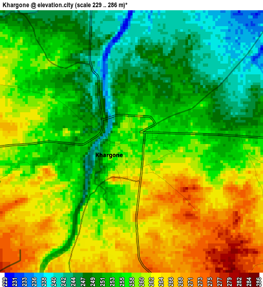
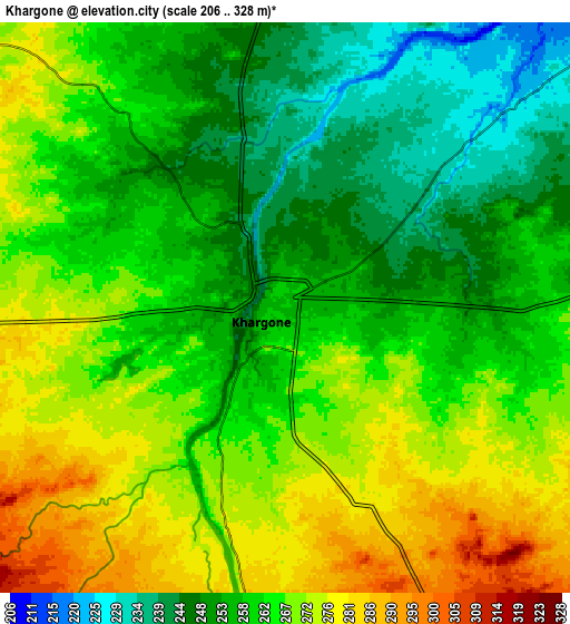
Below is the Elevation map of Khargone, which displays elevation range with different colors. Scale of the first map is from 229 to 286 m (751 to 938 ft) with average elevation of 256.1 meters (=840 ft) [note 1]
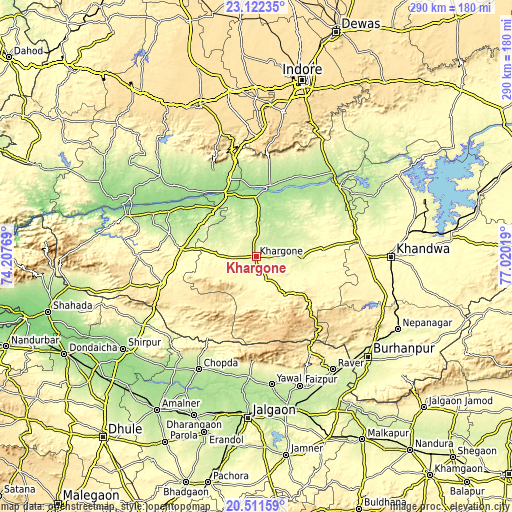
These maps also provides idea of topography and contour of this city, they are displayed at different zoom levels. More info about maps, scale and edge coordinates you can find below images.
| \ | Map #1 | Map #2 | Topo.Map |
| Scale [m] | 229..286 m | 206..328 m | × |
| Scale [ft] | 751..938 ft | 676..1076 ft | × |
| Average | 256.1 m = 840 ft | 262.2 m = 860 ft | × |
| Width | 9.07 km = 5.6 mi | 18.14 km = 11.3 mi | 290.3 km = 180.4 mi |
| Height | 9.07 km = 5.6 mi | 18.14 km = 11.3 mi | 290.3 km = 180.4 mi |
| ↑Max Latitude | 21.86371° | 21.904489° | 23.12235° |
| Latitude at center | 21.82292° | 21.82292° | 21.82292° |
| ↓Min Latitude | 21.782118° | 21.741305° | 20.51159° |
| ← Min Longitude | 75.569995° | 75.526049° | 74.20769° |
| Longitude center | 75.61394° | 75.61394° | 75.61394° |
| →Max Longitude | 75.657885° | 75.701831° | 77.02019° |
Nearby cities:
Cities around Khargone sort by population:
• Sendhwa elevation 410 m
55.6 km,  254°
254°
• Sanāwad 197 m
61.1 km,  50°
50°
• Dhāmnod 177 m
45.4 km,  341°
341°
• Anjad 165 m
62.6 km,  292°
292°
• Maheshwar 161 m
39.3 km,  355°
355°
• Kasrāwad 182 m
33.9 km, 359°
• Rajpur 231 m
51 km,  284°
284°
• Bhikangaon 283 m
36.5 km,  82°
82°
• Dharampuri 153 m
45.7 km,  322°
322°
• Māndleshwar 165 m
39.5 km,  6°
6°
• Pandhāna 364 m
64.6 km,  102°
102°
• Mānpur 577 m
67.7 km,  0°
0°
Multilingual:
 En español:
Khargone elevación 258 m.
 En France:
Khargone élévation 258 m.
 Auf Deutsch:
Khargone höhe über dem Meeresspiegel ist 258 m.

Sources and notes:
- [note 1] Map square and city borders are not equal. Map elevation data is calculated only from area inside that square.
- [src 1] Elevation data from geonames database provided with same terms of usage.
- [src 2] The elevation map of Khargone is generated using elevation data from NASA's 3 arcsec (90m) resolution SRTM data.
- [src 3] Base (background) map © OpenStreetMap contributors tiles are generated by Geofabrik and OpenTopoMap.
Copyright & License:
This Khargone Elevation Map is licensed under CC BY-SA. You may reuse any part from this page, if you give a proper credit by linking to this URL:
 More info on terms of use page.