Shikohābād elevation
Shikohābād (Uttar Pradesh, Firozabad), India elevation is 165 meters and Shikohābād elevation in feet is 541 ft above sea level [src 1]. Shikohābād is a populated place (feature code) with elevation that is 128 meters (420 ft) smaller than average city elevation in India.
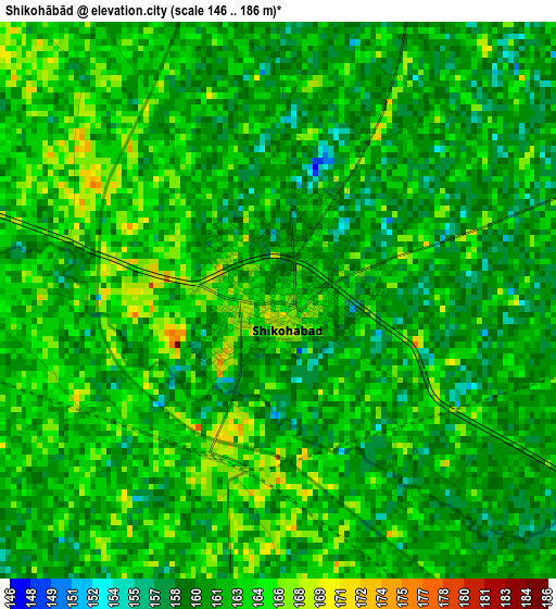
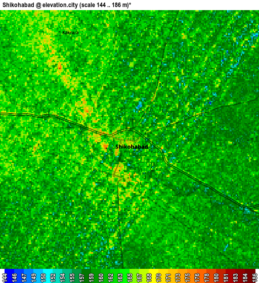
Below is the Elevation map of Shikohābād, which displays elevation range with different colors. Scale of the first map is from 146 to 186 m (479 to 610 ft) with average elevation of 162 meters (=531 ft) [note 1]
These maps also provides idea of topography and contour of this city, they are displayed at different zoom levels. More info about maps, scale and edge coordinates you can find below images.
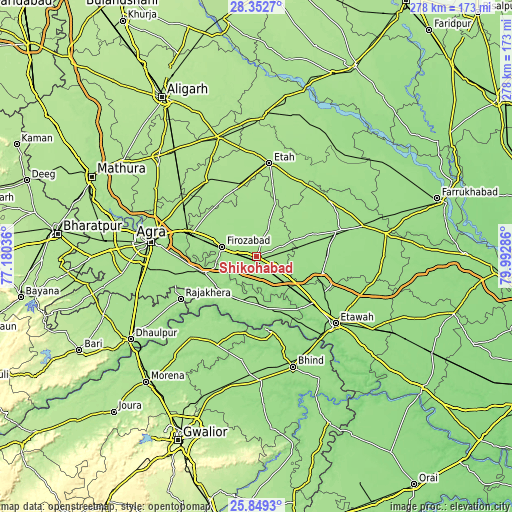
| \ | Map #1 | Map #2 | Topo.Map |
| Scale [m] | 146..186 m | 144..186 m | × |
| Scale [ft] | 479..610 ft | 472..610 ft | × |
| Average | 162 m = 531 ft | 161.2 m = 529 ft | × |
| Width | 8.7 km = 5.4 mi | 17.4 km = 10.8 mi | 278.4 km = 173 mi |
| Height | 8.7 km = 5.4 mi | 17.4 km = 10.8 mi | 278.4 km = 173 mi |
| ↑Max Latitude | 27.147111° | 27.186208° | 28.3527° |
| Latitude at center | 27.108° | 27.108° | 27.108° |
| ↓Min Latitude | 27.068875° | 27.029737° | 25.8493° |
| ← Min Longitude | 78.542665° | 78.498719° | 77.18036° |
| Longitude center | 78.58661° | 78.58661° | 78.58661° |
| →Max Longitude | 78.630555° | 78.674501° | 79.99286° |
Nearby cities:
Cities around Shikohābād sort by population:
• Fīrozābād elevation 169 m
19.3 km,  284°
284°
• Tūndla 167 m
36.6 km,  288°
288°
• Sirsāganj 165 m
11.4 km,  119°
119°
• Jaswantnagar 158 m
40.1 km,  128°
128°
• Karhal 160 m
36.9 km,  108°
108°
• Itimādpur 167 m
40.9 km, 290°
• Fatehābād 169 m
29.5 km,  252°
252°
• Pināhat 159 m
32.4 km,  220°
220°
• Bāh 160 m
26.6 km,  178°
178°
• Ghiror 162 m
22.3 km,  66°
66°
• Jasrāna 168 m
15.6 km,  24°
24°
• Pharihā 171 m
26.3 km,  334°
334°
Multilingual:
 En español:
Shikohābād elevación 165 m.
 En France:
Shikohābād élévation 165 m.
 Auf Deutsch:
Shikohābād höhe über dem Meeresspiegel ist 165 m.

Sources and notes:
- [note 1] Map square and city borders are not equal. Map elevation data is calculated only from area inside that square.
- [src 1] Elevation data from geonames database provided with same terms of usage.
- [src 2] The elevation map of Shikohābād is generated using elevation data from NASA's 3 arcsec (90m) resolution SRTM data.
- [src 3] Base (background) map © OpenStreetMap contributors tiles are generated by Geofabrik and OpenTopoMap.
Copyright & License:
This Shikohābād Elevation Map is licensed under CC BY-SA. You may reuse any part from this page, if you give a proper credit by linking to this URL:
 More info on terms of use page.