Shorāpur elevation
Shorāpur (Karnataka, Yadgir), India elevation is 480 meters and Shorāpur elevation in feet is 1575 ft above sea level [src 1]. Shorāpur is a populated place (feature code) with elevation that is 187 meters (614 ft) bigger than average city elevation in India.
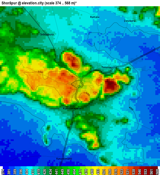
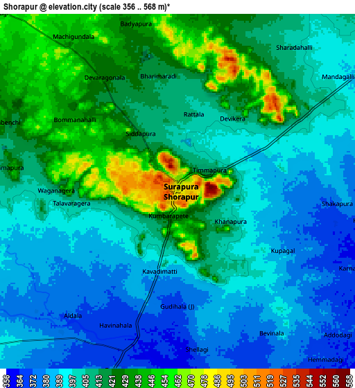
Below is the Elevation map of Shorāpur, which displays elevation range with different colors. Scale of the first map is from 374 to 568 m (1227 to 1864 ft) with average elevation of 422.8 meters (=1387 ft) [note 1]
These maps also provides idea of topography and contour of this city, they are displayed at different zoom levels. More info about maps, scale and edge coordinates you can find below images.
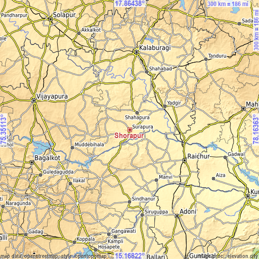
| \ | Map #1 | Map #2 | Topo.Map |
| Scale [m] | 374..568 m | 356..568 m | × |
| Scale [ft] | 1227..1864 ft | 1168..1864 ft | × |
| Average | 422.8 m = 1387 ft | 407 m = 1335 ft | × |
| Width | 9.37 km = 5.8 mi | 18.74 km = 11.6 mi | 299.8 km = 186.3 mi |
| Height | 9.37 km = 5.8 mi | 18.74 km = 11.6 mi | 299.8 km = 186.3 mi |
| ↑Max Latitude | 16.563126° | 16.605244° | 17.86438° |
| Latitude at center | 16.521° | 16.521° | 16.521° |
| ↓Min Latitude | 16.478864° | 16.43672° | 15.16822° |
| ← Min Longitude | 76.713435° | 76.669489° | 75.35113° |
| Longitude center | 76.75738° | 76.75738° | 76.75738° |
| →Max Longitude | 76.801325° | 76.845271° | 78.16363° |
Nearby cities:
Cities around Shorāpur sort by population:
• Rāichūr elevation 402 m
72.8 km,  118°
118°
• Yādgīr 379 m
49.1 km,  55°
55°
• Shāhābād 394 m
70.6 km,  16°
16°
• Mānvi 375 m
66.7 km,  152°
152°
• Sindgi 503 m
71.2 km,  308°
308°
• Muddebihāl 586 m
69.8 km,  253°
253°
• Shāhpur 418 m
21.5 km, 24°
• Wādi 431 m
64 km, 22°
• Lingsugūr 509 m
47.5 km,  211°
211°
• Tālīkota 513 m
47.9 km,  263°
263°
• Mudgal 552 m
65.9 km, 210°
• Jevargi 411 m
54.8 km,  1°
1°
Multilingual:
 En español:
Shorāpur elevación 480 m.
 En France:
Shorāpur élévation 480 m.
 Auf Deutsch:
Shorāpur höhe über dem Meeresspiegel ist 480 m.

Sources and notes:
- [note 1] Map square and city borders are not equal. Map elevation data is calculated only from area inside that square.
- [src 1] Elevation data from geonames database provided with same terms of usage.
- [src 2] The elevation map of Shorāpur is generated using elevation data from NASA's 3 arcsec (90m) resolution SRTM data.
- [src 3] Base (background) map © OpenStreetMap contributors tiles are generated by Geofabrik and OpenTopoMap.
Copyright & License:
This Shorāpur Elevation Map is licensed under CC BY-SA. You may reuse any part from this page, if you give a proper credit by linking to this URL:
 More info on terms of use page.