Wādi elevation
Wādi (Karnataka, Gulbarga), India elevation is 431 meters and Wādi elevation in feet is 1414 ft above sea level [src 1]. Wādi is a populated place (feature code) with elevation that is 138 meters (453 ft) bigger than average city elevation in India.
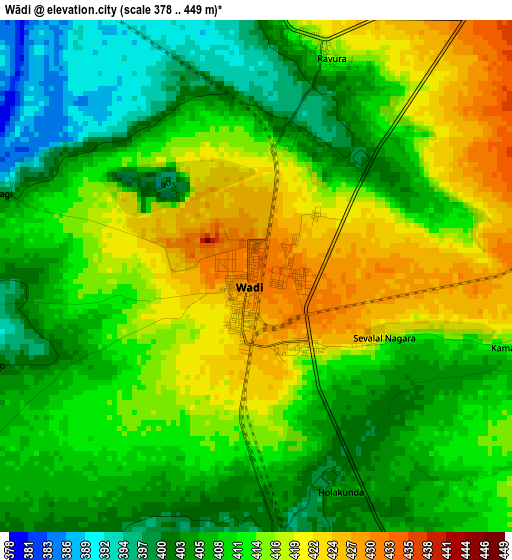
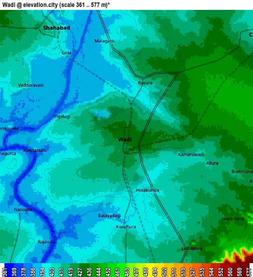
Below is the Elevation map of Wādi, which displays elevation range with different colors. Scale of the first map is from 378 to 449 m (1240 to 1473 ft) with average elevation of 411.3 meters (=1349 ft) [note 1]
These maps also provides idea of topography and contour of this city, they are displayed at different zoom levels. More info about maps, scale and edge coordinates you can find below images.
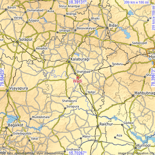
| \ | Map #1 | Map #2 | Topo.Map |
| Scale [m] | 378..449 m | 361..577 m | × |
| Scale [ft] | 1240..1473 ft | 1184..1893 ft | × |
| Average | 411.3 m = 1349 ft | 411 m = 1348 ft | × |
| Width | 9.34 km = 5.8 mi | 18.69 km = 11.6 mi | 298.9 km = 185.7 mi |
| Height | 9.34 km = 5.8 mi | 18.69 km = 11.6 mi | 299 km = 185.8 mi |
| ↑Max Latitude | 17.093839° | 17.135838° | 18.39131° |
| Latitude at center | 17.05183° | 17.05183° | 17.05183° |
| ↓Min Latitude | 17.009812° | 16.967784° | 15.70267° |
| ← Min Longitude | 76.946535° | 76.902589° | 75.58423° |
| Longitude center | 76.99048° | 76.99048° | 76.99048° |
| →Max Longitude | 77.034425° | 77.078371° | 78.39673° |
Nearby cities:
Cities around Wādi sort by population:
• Gulbarga elevation 474 m
35.5 km,  332°
332°
• Yādgīr 379 m
35 km,  153°
153°
• Shāhābād 394 m
10.1 km, 330°
• Shorāpur 480 m
64 km,  202°
202°
• Nārāyanpet 443 m
63.5 km,  122°
122°
• Seram 425 m
34.8 km,  66°
66°
• Shāhpur 418 m
42.6 km, 201°
• Chītāpur 411 m
12.6 km,  50°
50°
• Chincholi 462 m
64.6 km,  44°
44°
• Jevargi 411 m
23.5 km,  259°
259°
• Gurmatkāl 594 m
47.2 km, 115°
• Kurgunta 425 m
42.1 km, 68°
Multilingual:
 En español:
Wādi elevación 431 m.
 En France:
Wādi élévation 431 m.


Sources and notes:
- [note 1] Map square and city borders are not equal. Map elevation data is calculated only from area inside that square.
- [src 1] Elevation data from geonames database provided with same terms of usage.
- [src 2] The elevation map of Wādi is generated using elevation data from NASA's 3 arcsec (90m) resolution SRTM data.
- [src 3] Base (background) map © OpenStreetMap contributors tiles are generated by Geofabrik and OpenTopoMap.
Copyright & License:
This Wādi Elevation Map is licensed under CC BY-SA. You may reuse any part from this page, if you give a proper credit by linking to this URL:
 More info on terms of use page.