Gulbarga elevation
Gulbarga (Karnataka), India elevation is 474 meters and Gulbarga elevation in feet is 1555 ft above sea level [src 1]. Gulbarga is a populated place (feature code) with elevation that is 181 meters (594 ft) bigger than average city elevation in India.
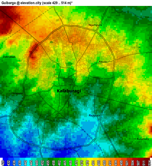
Below is the Elevation map of Gulbarga, which displays elevation range with different colors. Scale of the first map is from 429 to 514 m (1407 to 1686 ft) with average elevation of 465.6 meters (=1528 ft) [note 1]
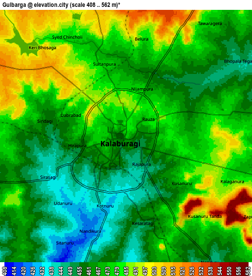
These maps also provides idea of topography and contour of this city, they are displayed at different zoom levels. More info about maps, scale and edge coordinates you can find below images.
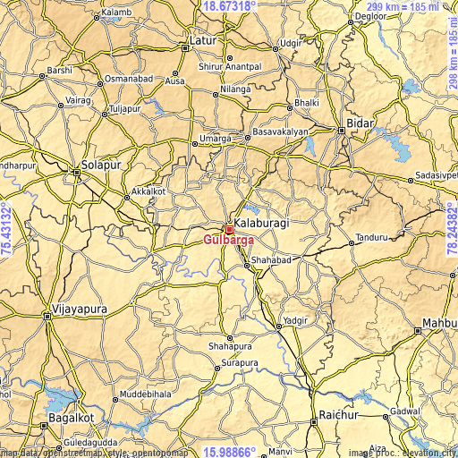
| \ | Map #1 | Map #2 | Topo.Map |
| Scale [m] | 429..514 m | 408..562 m | × |
| Scale [ft] | 1407..1686 ft | 1339..1844 ft | × |
| Average | 465.6 m = 1528 ft | 471.9 m = 1548 ft | × |
| Width | 9.33 km = 5.8 mi | 18.66 km = 11.6 mi | 298.5 km = 185.5 mi |
| Height | 9.33 km = 5.8 mi | 18.66 km = 11.6 mi | 298.5 km = 185.5 mi |
| ↑Max Latitude | 17.377774° | 17.419709° | 18.67318° |
| Latitude at center | 17.33583° | 17.33583° | 17.33583° |
| ↓Min Latitude | 17.293876° | 17.251913° | 15.98866° |
| ← Min Longitude | 76.793625° | 76.749679° | 75.43132° |
| Longitude center | 76.83757° | 76.83757° | 76.83757° |
| →Max Longitude | 76.881515° | 76.925461° | 78.24382° |
Nearby cities:
Cities around Gulbarga sort by population:
• Shāhābād elevation 394 m
25.4 km,  153°
153°
• Homnābād 641 m
57.2 km,  32°
32°
• Aland 499 m
38.2 km,  311°
311°
• Seram 425 m
51.1 km,  109°
109°
• Umarga 580 m
60.3 km,  337°
337°
• Wādi 431 m
35.5 km, 152°
• Chītāpur 411 m
35.1 km,  132°
132°
• Jevargi 411 m
36.4 km,  190°
190°
• Afzalpur 422 m
52.9 km,  253°
253°
• Dudhani 445 m
50 km,  272°
272°
• Maindargi 449 m
59.3 km,  283°
283°
• Kurgunta 425 m
57.5 km, 106°
Multilingual:
 En español:
Gulbarga elevación 474 m.
 En France:
Gulbarga élévation 474 m.
 Auf Deutsch:
Gulbarga höhe über dem Meeresspiegel ist 474 m.
 На русском:
Гульбарга, Гулбарга высота над уровнем моря 474 м
Sources and notes:
- [note 1] Map square and city borders are not equal. Map elevation data is calculated only from area inside that square.
- [src 1] Elevation data from geonames database provided with same terms of usage.
- [src 2] The elevation map of Gulbarga is generated using elevation data from NASA's 3 arcsec (90m) resolution SRTM data.
- [src 3] Base (background) map © OpenStreetMap contributors tiles are generated by Geofabrik and OpenTopoMap.
Copyright & License:
This Gulbarga Elevation Map is licensed under CC BY-SA. You may reuse any part from this page, if you give a proper credit by linking to this URL:
 More info on terms of use page.