Surgāna elevation
Surgāna (Maharashtra, Nashik Division), India elevation is 526 meters and Surgāna elevation in feet is 1726 ft above sea level [src 1]. Surgāna is a populated place (feature code) with elevation that is 233 meters (764 ft) bigger than average city elevation in India.
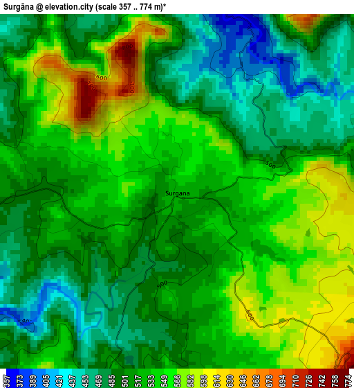
Below is the Elevation map of Surgāna, which displays elevation range with different colors. Scale of the first map is from 357 to 774 m (1171 to 2539 ft) with average elevation of 520.9 meters (=1709 ft) [note 1]
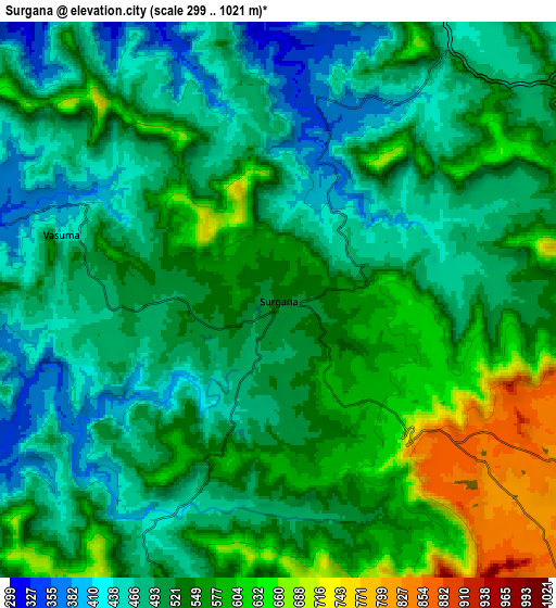
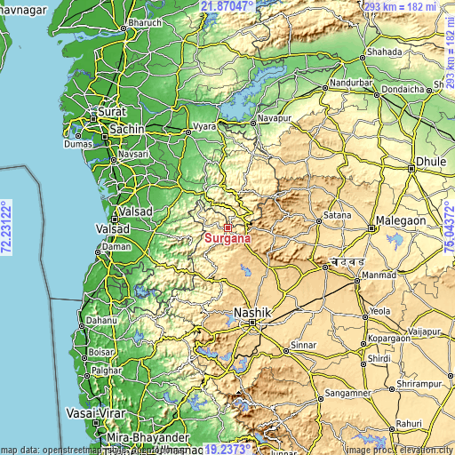
These maps also provides idea of topography and contour of this city, they are displayed at different zoom levels. More info about maps, scale and edge coordinates you can find below images.
| \ | Map #1 | Map #2 | Topo.Map |
| Scale [m] | 357..774 m | 299..1021 m | × |
| Scale [ft] | 1171..2539 ft | 981..3350 ft | × |
| Average | 520.9 m = 1709 ft | 522.9 m = 1716 ft | × |
| Width | 9.15 km = 5.7 mi | 18.3 km = 11.4 mi | 292.8 km = 181.9 mi |
| Height | 9.15 km = 5.7 mi | 18.3 km = 11.4 mi | 292.8 km = 181.9 mi |
| ↑Max Latitude | 20.600701° | 20.64183° | 21.87047° |
| Latitude at center | 20.55956° | 20.55956° | 20.55956° |
| ↓Min Latitude | 20.518408° | 20.477245° | 19.2373° |
| ← Min Longitude | 73.593525° | 73.549579° | 72.23122° |
| Longitude center | 73.63747° | 73.63747° | 73.63747° |
| →Max Longitude | 73.681415° | 73.725361° | 75.04372° |
Nearby cities:
Cities around Surgāna sort by population:
• Nashik elevation 584 m
64.5 km,  165°
165°
• Ozar 591 m
59.9 km,  149°
149°
• Vyāra 90 m
66.3 km,  337°
337°
• Satānā 557 m
59 km,  86°
86°
• Songadh 118 m
68.3 km,  353°
353°
• Dharampur 76 m
48.4 km,  267°
267°
• Chāndor 734 m
68.2 km,  111°
111°
• Ahwa 474 m
22.6 km,  13°
13°
• Vānsada 116 m
36 km,  307°
307°
• Trimbak 724 m
70.6 km,  189°
189°
• Chikhli 29 m
63.7 km,  290°
290°
• Waghāi 147 m
27.4 km,  328°
328°
Multilingual:
 En español:
Surgāna elevación 526 m.
 En France:
Surgāna élévation 526 m.


Sources and notes:
- [note 1] Map square and city borders are not equal. Map elevation data is calculated only from area inside that square.
- [src 1] Elevation data from geonames database provided with same terms of usage.
- [src 2] The elevation map of Surgāna is generated using elevation data from NASA's 3 arcsec (90m) resolution SRTM data.
- [src 3] Base (background) map © OpenStreetMap contributors tiles are generated by Geofabrik and OpenTopoMap.
Copyright & License:
This Surgāna Elevation Map is licensed under CC BY-SA. You may reuse any part from this page, if you give a proper credit by linking to this URL:
 More info on terms of use page.