Vyāra elevation
Vyāra (Gujarat, Tapi), India elevation is 90 meters and Vyāra elevation in feet is 295 ft above sea level [src 1]. Vyāra is a populated place (feature code) with elevation that is 203 meters (666 ft) smaller than average city elevation in India.
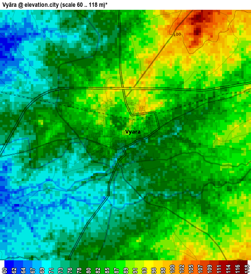
Below is the Elevation map of Vyāra, which displays elevation range with different colors. Scale of the first map is from 60 to 118 m (197 to 387 ft) with average elevation of 81.4 meters (=267 ft) [note 1]
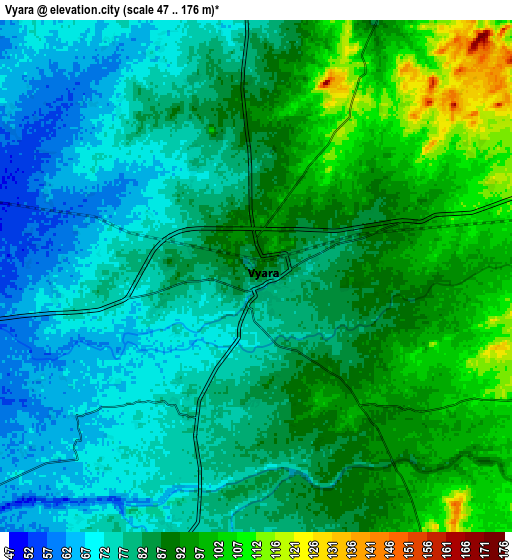
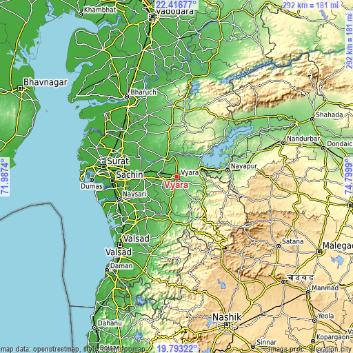
These maps also provides idea of topography and contour of this city, they are displayed at different zoom levels. More info about maps, scale and edge coordinates you can find below images.
| \ | Map #1 | Map #2 | Topo.Map |
| Scale [m] | 60..118 m | 47..176 m | × |
| Scale [ft] | 197..387 ft | 154..577 ft | × |
| Average | 81.4 m = 267 ft | 84 m = 276 ft | × |
| Width | 9.12 km = 5.7 mi | 18.23 km = 11.3 mi | 291.7 km = 181.3 mi |
| Height | 9.12 km = 5.7 mi | 18.23 km = 11.3 mi | 291.7 km = 181.3 mi |
| ↑Max Latitude | 21.15178° | 21.192759° | 22.41677° |
| Latitude at center | 21.11079° | 21.11079° | 21.11079° |
| ↓Min Latitude | 21.069788° | 21.028775° | 19.79322° |
| ← Min Longitude | 73.349705° | 73.305759° | 71.9874° |
| Longitude center | 73.39365° | 73.39365° | 73.39365° |
| →Max Longitude | 73.437595° | 73.481541° | 74.7999° |
Nearby cities:
Cities around Vyāra sort by population:
• Navsāri elevation 14 m
52.2 km,  248°
248°
• Bārdoli 29 m
29.3 km,  272°
272°
• Songadh 118 m
18.8 km,  69°
69°
• Māndvi 45 m
18.6 km,  329°
329°
• Kadod 42 m
21.6 km,  303°
303°
• Gandevi 19 m
52.8 km,  231°
231°
• Kāthor 23 m
50.9 km,  292°
292°
• Ahwa 474 m
49.7 km,  142°
142°
• Vānsada 116 m
39.3 km,  184°
184°
• Sachīn 16 m
53.2 km, 267°
• Chikhli 29 m
52.2 km,  221°
221°
• Waghāi 147 m
39.4 km,  163°
163°
Multilingual:
 En español:
Vyāra elevación 90 m.
 En France:
Vyāra élévation 90 m.


Sources and notes:
- [note 1] Map square and city borders are not equal. Map elevation data is calculated only from area inside that square.
- [src 1] Elevation data from geonames database provided with same terms of usage.
- [src 2] The elevation map of Vyāra is generated using elevation data from NASA's 3 arcsec (90m) resolution SRTM data.
- [src 3] Base (background) map © OpenStreetMap contributors tiles are generated by Geofabrik and OpenTopoMap.
Copyright & License:
This Vyāra Elevation Map is licensed under CC BY-SA. You may reuse any part from this page, if you give a proper credit by linking to this URL:
 More info on terms of use page.