Tawang elevation
Tawang (Arunachal Pradesh), India elevation is 2432 meters and Tawang elevation in feet is 7979 ft above sea level [src 1]. Tawang is a populated place (feature code) with elevation that is 2139 meters (7018 ft) bigger than average city elevation in India.
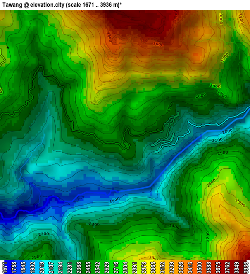
Below is the Elevation map of Tawang, which displays elevation range with different colors. Scale of the first map is from 1671 to 3936 m (5482 to 12913 ft) with average elevation of 2586.2 meters (=8485 ft) [note 1]
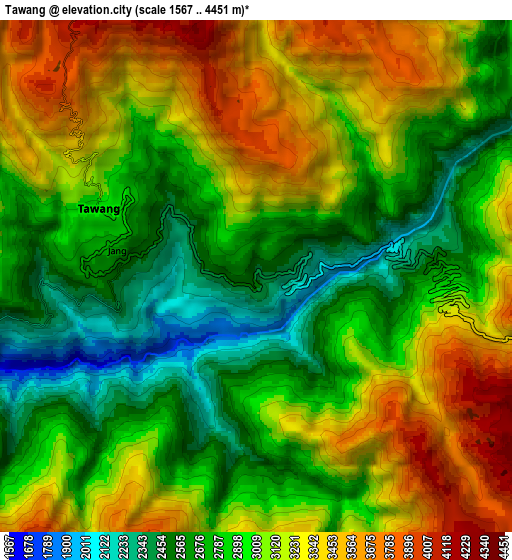
These maps also provides idea of topography and contour of this city, they are displayed at different zoom levels. More info about maps, scale and edge coordinates you can find below images.
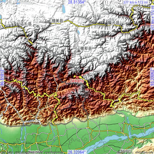
| \ | Map #1 | Map #2 | Topo.Map |
| Scale [m] | 1671..3936 m | 1567..4451 m | × |
| Scale [ft] | 5482..12913 ft | 5141..14603 ft | × |
| Average | 2586.2 m = 8485 ft | 3015.2 m = 9892 ft | × |
| Width | 8.66 km = 5.4 mi | 17.33 km = 10.8 mi | 277.2 km = 172.2 mi |
| Height | 8.66 km = 5.4 mi | 17.33 km = 10.8 mi | 277.2 km = 172.2 mi |
| ↑Max Latitude | 27.613117° | 27.65205° | 28.81354° |
| Latitude at center | 27.57417° | 27.57417° | 27.57417° |
| ↓Min Latitude | 27.535209° | 27.496235° | 26.32064° |
| ← Min Longitude | 91.880425° | 91.836479° | 90.51812° |
| Longitude center | 91.92437° | 91.92437° | 91.92437° |
| →Max Longitude | 91.968315° | 92.012261° | 93.33062° |
Nearby cities:
Cities around Tawang sort by population:
• Tezpur elevation 74 m
135.8 km,  140°
140°
• Barpeta Road 49 m
152.1 km,  218°
218°
• Rangia 62 m
128.8 km,  193°
193°
• Mangaldai 62 m
126.3 km,  175°
175°
• Dhekiajuli 83 m
111.2 km,  150°
150°
• Dhing 69 m
134.5 km,  156°
156°
• Rangāpāra 91 m
110.1 km, 138°
• Khārupatia 66 m
119.4 km,  169°
169°
• Hājo 58 m
153 km, 194°
• Udalguri 116 m
92.9 km, 169°
• Bomdila 2507 m
60.2 km,  124°
124°
• Mushalpur 61 m
121.1 km,  204°
204°
Multilingual:
 En español:
Tawang elevación 2432 m.
 En France:
Tawang élévation 2432 m.


Sources and notes:
- [note 1] Map square and city borders are not equal. Map elevation data is calculated only from area inside that square.
- [src 1] Elevation data from geonames database provided with same terms of usage.
- [src 2] The elevation map of Tawang is generated using elevation data from NASA's 3 arcsec (90m) resolution SRTM data.
- [src 3] Base (background) map © OpenStreetMap contributors tiles are generated by Geofabrik and OpenTopoMap.
Copyright & License:
This Tawang Elevation Map is licensed under CC BY-SA. You may reuse any part from this page, if you give a proper credit by linking to this URL:
 More info on terms of use page.