Rangia elevation
Rangia (Assam, Kāmrūp), India elevation is 62 meters and Rangia elevation in feet is 203 ft above sea level [src 1]. Rangia is a populated place (feature code) with elevation that is 231 meters (758 ft) smaller than average city elevation in India.
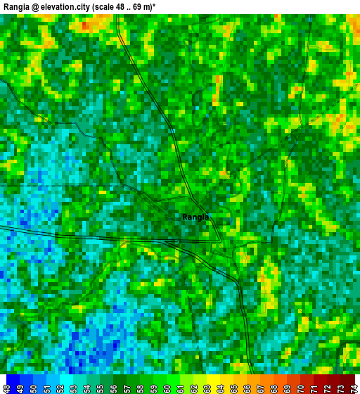
Below is the Elevation map of Rangia, which displays elevation range with different colors. Scale of the first map is from 48 to 69 m (157 to 226 ft) with average elevation of 56.4 meters (=185 ft) [note 1]
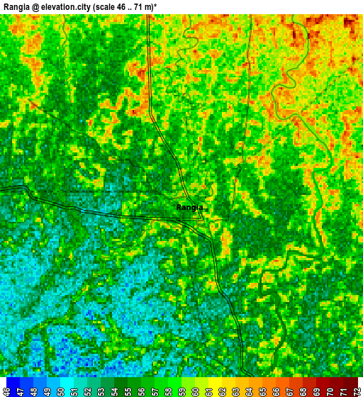
These maps also provides idea of topography and contour of this city, they are displayed at different zoom levels. More info about maps, scale and edge coordinates you can find below images.
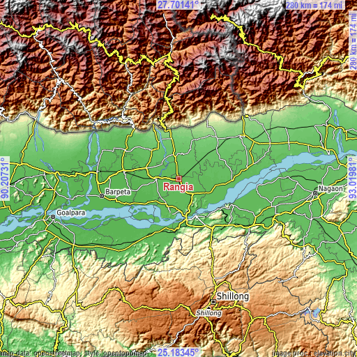
| \ | Map #1 | Map #2 | Topo.Map |
| Scale [m] | 48..69 m | 46..71 m | × |
| Scale [ft] | 157..226 ft | 151..233 ft | × |
| Average | 56.4 m = 185 ft | 56.5 m = 185 ft | × |
| Width | 8.75 km = 5.4 mi | 17.5 km = 10.9 mi | 280 km = 174 mi |
| Height | 8.75 km = 5.4 mi | 17.5 km = 10.9 mi | 280 km = 174 mi |
| ↑Max Latitude | 26.488649° | 26.527974° | 27.70141° |
| Latitude at center | 26.44931° | 26.44931° | 26.44931° |
| ↓Min Latitude | 26.409958° | 26.370592° | 25.18345° |
| ← Min Longitude | 91.569615° | 91.525669° | 90.20731° |
| Longitude center | 91.61356° | 91.61356° | 91.61356° |
| →Max Longitude | 91.657505° | 91.701451° | 93.01981° |
Nearby cities:
Cities around Rangia sort by population:
• Guwahati elevation 59 m
32.3 km,  155°
155°
• Barpeta 47 m
62.1 km,  256°
256°
• Mangaldai 62 m
41.5 km,  91°
91°
• Khārupatia 66 m
53.7 km,  81°
81°
• North Guwāhāti 57 m
29.9 km, 159°
• Howli 52 m
63.1 km,  267°
267°
• Hājo 58 m
24.3 km,  201°
201°
• Udalguri 116 m
59.2 km,  55°
55°
• Soalkuchi 55 m
31.6 km,  187°
187°
• Dispur 60 m
39.6 km,  151°
151°
• Palāsbāri 52 m
36.9 km, 191°
• Mushalpur 61 m
23.6 km,  307°
307°
Multilingual:
 En español:
Rangia elevación 62 m.
 En France:
Rangia élévation 62 m.


Sources and notes:
- [note 1] Map square and city borders are not equal. Map elevation data is calculated only from area inside that square.
- [src 1] Elevation data from geonames database provided with same terms of usage.
- [src 2] The elevation map of Rangia is generated using elevation data from NASA's 3 arcsec (90m) resolution SRTM data.
- [src 3] Base (background) map © OpenStreetMap contributors tiles are generated by Geofabrik and OpenTopoMap.
Copyright & License:
This Rangia Elevation Map is licensed under CC BY-SA. You may reuse any part from this page, if you give a proper credit by linking to this URL:
 More info on terms of use page.