Ooty elevation
Ooty (Tamil Nadu, Nilgiris), India elevation is 2242 meters and Ooty elevation in feet is 7356 ft above sea level [src 1]. Ooty is a populated place (feature code) with elevation that is 1949 meters (6394 ft) bigger than average city elevation in India.
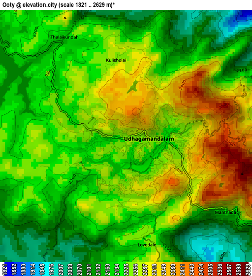
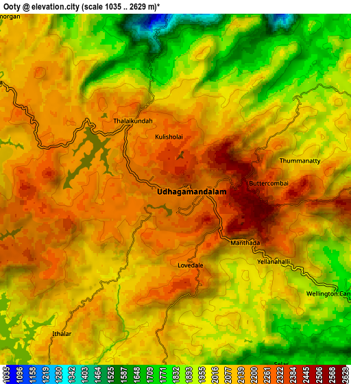
Below is the Elevation map of Ooty, which displays elevation range with different colors. Scale of the first map is from 1821 to 2629 m (5974 to 8625 ft) with average elevation of 2219.3 meters (=7281 ft) [note 1]
These maps also provides idea of topography and contour of this city, they are displayed at different zoom levels. More info about maps, scale and edge coordinates you can find below images.
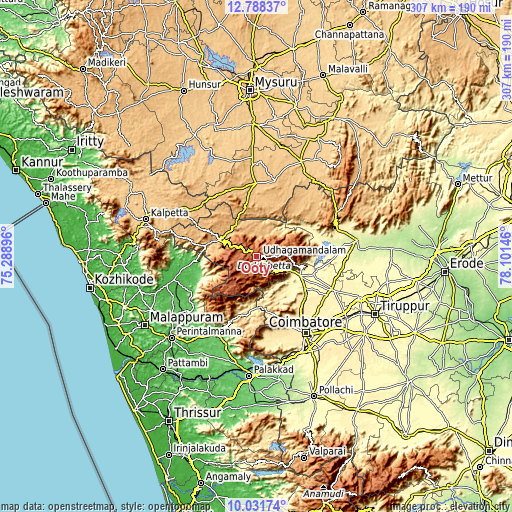
| \ | Map #1 | Map #2 | Topo.Map |
| Scale [m] | 1821..2629 m | 1035..2629 m | × |
| Scale [ft] | 5974..8625 ft | 3396..8625 ft | × |
| Average | 2219.3 m = 7281 ft | 2057.5 m = 6750 ft | × |
| Width | 9.58 km = 6 mi | 19.16 km = 11.9 mi | 306.5 km = 190.4 mi |
| Height | 9.58 km = 6 mi | 19.16 km = 11.9 mi | 306.5 km = 190.4 mi |
| ↑Max Latitude | 11.456473° | 11.499539° | 12.78837° |
| Latitude at center | 11.4134° | 11.4134° | 11.4134° |
| ↓Min Latitude | 11.37032° | 11.327234° | 10.03174° |
| ← Min Longitude | 76.651265° | 76.607319° | 75.28896° |
| Longitude center | 76.69521° | 76.69521° | 76.69521° |
| →Max Longitude | 76.739155° | 76.783101° | 78.10146° |
Nearby cities:
Cities around Ooty sort by population:
• Mettupalayam elevation 331 m
29 km,  115°
115°
• Kāramadai 367 m
34.7 km, 123°
• Kotagiri 1902 m
18 km,  87°
87°
• Gundlupēt 799 m
44.1 km,  359°
359°
• Periyanayakkanpalaiyam 429 m
40.3 km,  136°
136°
• Wellington 1847 m
11.1 km, 118°
• Sirumugai 288 m
35.3 km,  106°
106°
• Annur 378 m
48.8 km, 113°
• Punjai Puliyampatti 308 m
51.9 km,  97°
97°
• Naduvattam 1855 m
18.1 km,  294°
294°
• Masinigudi 946 m
18.2 km,  341°
341°
• Aruvankad 1920 m
8.8 km,  129°
129°
Multilingual:
 En español:
Ooty elevación 2242 m.
 En France:
Ooty élévation 2242 m.
 Auf Deutsch:
Udagamandalam höhe über dem Meeresspiegel ist 2242 m.

Sources and notes:
- [note 1] Map square and city borders are not equal. Map elevation data is calculated only from area inside that square.
- [src 1] Elevation data from geonames database provided with same terms of usage.
- [src 2] The elevation map of Ooty is generated using elevation data from NASA's 3 arcsec (90m) resolution SRTM data.
- [src 3] Base (background) map © OpenStreetMap contributors tiles are generated by Geofabrik and OpenTopoMap.
Copyright & License:
This Ooty Elevation Map is licensed under CC BY-SA. You may reuse any part from this page, if you give a proper credit by linking to this URL:
 More info on terms of use page.