Annur elevation
Annur (Tamil Nadu, Coimbatore), India elevation is 378 meters and Annur elevation in feet is 1240 ft above sea level [src 1]. Annur is a populated place (feature code) with elevation that is 85 meters (279 ft) bigger than average city elevation in India.
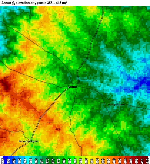
Below is the Elevation map of Annur, which displays elevation range with different colors. Scale of the first map is from 355 to 413 m (1165 to 1355 ft) with average elevation of 381.6 meters (=1252 ft) [note 1]
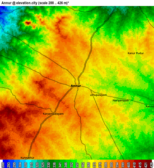
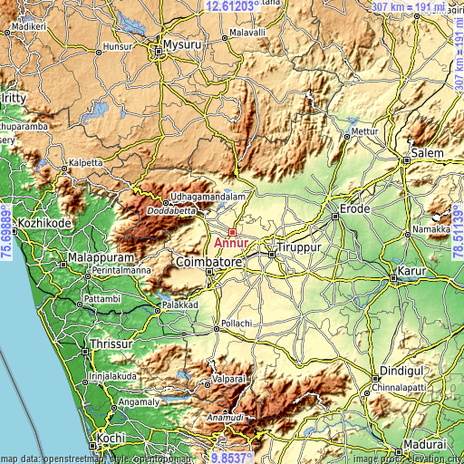
These maps also provides idea of topography and contour of this city, they are displayed at different zoom levels. More info about maps, scale and edge coordinates you can find below images.
| \ | Map #1 | Map #2 | Topo.Map |
| Scale [m] | 355..413 m | 288..426 m | × |
| Scale [ft] | 1165..1355 ft | 945..1398 ft | × |
| Average | 381.6 m = 1252 ft | 370.3 m = 1215 ft | × |
| Width | 9.59 km = 6 mi | 19.17 km = 11.9 mi | 306.7 km = 190.6 mi |
| Height | 9.59 km = 6 mi | 19.17 km = 11.9 mi | 306.7 km = 190.6 mi |
| ↑Max Latitude | 11.27926° | 11.322353° | 12.61203° |
| Latitude at center | 11.23616° | 11.23616° | 11.23616° |
| ↓Min Latitude | 11.193054° | 11.149941° | 9.8537° |
| ← Min Longitude | 77.061195° | 77.017249° | 75.69889° |
| Longitude center | 77.10514° | 77.10514° | 77.10514° |
| →Max Longitude | 77.149085° | 77.193031° | 78.51139° |
Nearby cities:
Cities around Annur sort by population:
• Coimbatore elevation 425 m
29.8 km,  210°
210°
• Tiruppur 305 m
30.3 km,  116°
116°
• Mettupalayam 331 m
19.9 km,  290°
290°
• Singānallūr 395 m
27.5 km,  196°
196°
• Kāramadai 367 m
15.8 km,  271°
271°
• Sulur 376 m
23.7 km,  174°
174°
• Periyanayakkanpalaiyam 429 m
19.2 km,  240°
240°
• Avinashi 330 m
18.5 km,  105°
105°
• Sirumugai 288 m
14.4 km,  311°
311°
• Irugūr 382 m
24.7 km,  190°
190°
• Nambiyūr 282 m
27.2 km,  60°
60°
• Punjai Puliyampatti 308 m
14.5 km,  27°
27°
Multilingual:
 En español:
Annur elevación 378 m.
 En France:
Annur élévation 378 m.


Sources and notes:
- [note 1] Map square and city borders are not equal. Map elevation data is calculated only from area inside that square.
- [src 1] Elevation data from geonames database provided with same terms of usage.
- [src 2] The elevation map of Annur is generated using elevation data from NASA's 3 arcsec (90m) resolution SRTM data.
- [src 3] Base (background) map © OpenStreetMap contributors tiles are generated by Geofabrik and OpenTopoMap.
Copyright & License:
This Annur Elevation Map is licensed under CC BY-SA. You may reuse any part from this page, if you give a proper credit by linking to this URL:
 More info on terms of use page.