Yeola elevation
Yeola (Maharashtra, Nashik Division), India elevation is 562 meters and Yeola elevation in feet is 1844 ft above sea level [src 1]. Yeola is a populated place (feature code) with elevation that is 269 meters (883 ft) bigger than average city elevation in India.
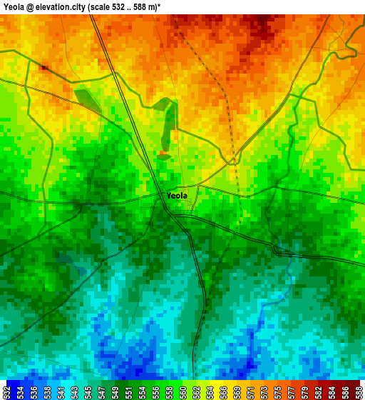
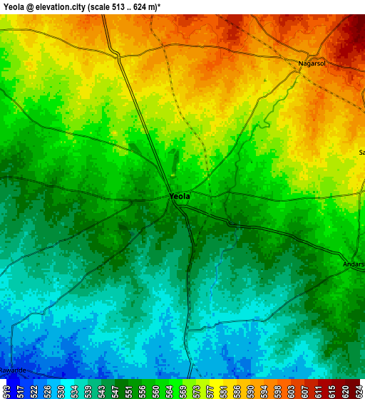
Below is the Elevation map of Yeola, which displays elevation range with different colors. Scale of the first map is from 532 to 588 m (1745 to 1929 ft) with average elevation of 557.2 meters (=1828 ft) [note 1]
These maps also provides idea of topography and contour of this city, they are displayed at different zoom levels. More info about maps, scale and edge coordinates you can find below images.
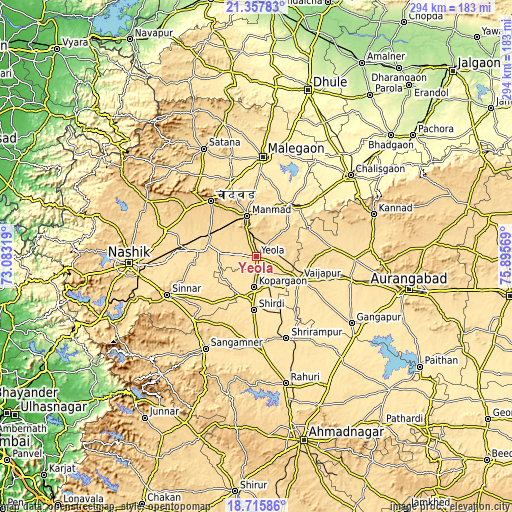
| \ | Map #1 | Map #2 | Topo.Map |
| Scale [m] | 532..588 m | 513..624 m | × |
| Scale [ft] | 1745..1929 ft | 1683..2047 ft | × |
| Average | 557.2 m = 1828 ft | 559.9 m = 1837 ft | × |
| Width | 9.18 km = 5.7 mi | 18.36 km = 11.4 mi | 293.8 km = 182.6 mi |
| Height | 9.18 km = 5.7 mi | 18.36 km = 11.4 mi | 293.8 km = 182.6 mi |
| ↑Max Latitude | 20.083679° | 20.124946° | 21.35783° |
| Latitude at center | 20.0424° | 20.0424° | 20.0424° |
| ↓Min Latitude | 20.001111° | 19.95981° | 18.71586° |
| ← Min Longitude | 74.445495° | 74.401549° | 73.08319° |
| Longitude center | 74.48944° | 74.48944° | 74.48944° |
| →Max Longitude | 74.533385° | 74.577331° | 75.89569° |
Nearby cities:
Cities around Yeola sort by population:
• Mālegaon elevation 432 m
56.6 km,  4°
4°
• Manmād 578 m
24.1 km,  346°
346°
• Sangamner 557 m
60.2 km,  208°
208°
• Kopargaon 504 m
17.8 km,  184°
184°
• Ozar 591 m
58.9 km,  275°
275°
• Vaijāpur 534 m
28 km,  117°
117°
• Sinnar 671 m
55.8 km,  246°
246°
• Shirdi 518 m
30.7 km, 182°
• Nāndgaon 480 m
34.1 km,  30°
30°
• Gangāpur 483 m
66.6 km,  125°
125°
• Chāndor 734 m
41 km,  321°
321°
• Lāsalgaon 590 m
28.4 km,  293°
293°
Multilingual:
 En español:
Yeola elevación 562 m.
 En France:
Yeola élévation 562 m.


Sources and notes:
- [note 1] Map square and city borders are not equal. Map elevation data is calculated only from area inside that square.
- [src 1] Elevation data from geonames database provided with same terms of usage.
- [src 2] The elevation map of Yeola is generated using elevation data from NASA's 3 arcsec (90m) resolution SRTM data.
- [src 3] Base (background) map © OpenStreetMap contributors tiles are generated by Geofabrik and OpenTopoMap.
Copyright & License:
This Yeola Elevation Map is licensed under CC BY-SA. You may reuse any part from this page, if you give a proper credit by linking to this URL:
 More info on terms of use page.