Gangāpur elevation
Gangāpur (Maharashtra, Aurangabad), India elevation is 483 meters and Gangāpur elevation in feet is 1585 ft above sea level [src 1]. Gangāpur is a populated place (feature code) with elevation that is 190 meters (623 ft) bigger than average city elevation in India.
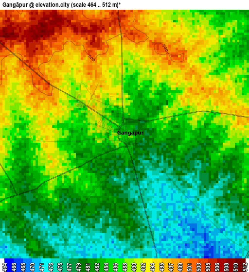
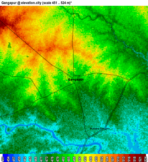
Below is the Elevation map of Gangāpur, which displays elevation range with different colors. Scale of the first map is from 464 to 512 m (1522 to 1680 ft) with average elevation of 486.1 meters (=1595 ft) [note 1]
These maps also provides idea of topography and contour of this city, they are displayed at different zoom levels. More info about maps, scale and edge coordinates you can find below images.
| \ | Map #1 | Map #2 | Topo.Map |
| Scale [m] | 464..512 m | 451..524 m | × |
| Scale [ft] | 1522..1680 ft | 1480..1719 ft | × |
| Average | 486.1 m = 1595 ft | 481.8 m = 1581 ft | × |
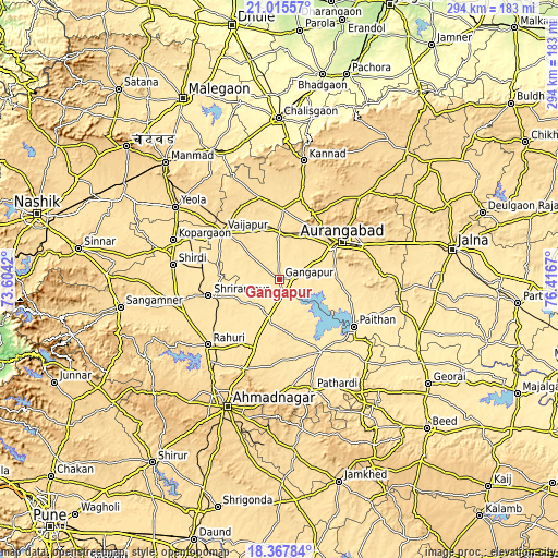
| Width | 9.2 km = 5.7 mi | 18.4 km = 11.4 mi | 294.4 km = 182.9 mi |
| Height | 9.2 km = 5.7 mi | 18.4 km = 11.4 mi | 294.4 km = 182.9 mi |
| ↑Max Latitude | 19.738549° | 19.779906° | 21.01557° |
| Latitude at center | 19.69718° | 19.69718° | 19.69718° |
| ↓Min Latitude | 19.655801° | 19.614411° | 18.36784° |
| ← Min Longitude | 74.966505° | 74.922559° | 73.6042° |
| Longitude center | 75.01045° | 75.01045° | 75.01045° |
| →Max Longitude | 75.054395° | 75.098341° | 76.4167° |
Nearby cities:
Cities around Gangāpur sort by population:
• Aurangabad elevation 588 m
40.1 km,  59°
59°
• Kopargaon 504 m
59.6 km,  290°
290°
• Yeola 562 m
66.6 km,  305°
305°
• Kannad 629 m
63.6 km,  12°
12°
• Vaijāpur 534 m
39.1 km, 310°
• Paithan 445 m
46.4 km,  122°
122°
• Rāhuri 511 m
50.9 km,  227°
227°
• Shirdi 518 m
56.3 km,  277°
277°
• Pāthardi 550 m
60.8 km,  163°
163°
• Pīpri 536 m
56 km,  78°
78°
• Khuldābād 734 m
39.3 km,  28°
28°
• Daulatābād 597 m
34.5 km,  39°
39°
Multilingual:
 En español:
Gangāpur elevación 483 m.
 En France:
Gangāpur élévation 483 m.
 Auf Deutsch:
Gangāpur höhe über dem Meeresspiegel ist 483 m.

Sources and notes:
- [note 1] Map square and city borders are not equal. Map elevation data is calculated only from area inside that square.
- [src 1] Elevation data from geonames database provided with same terms of usage.
- [src 2] The elevation map of Gangāpur is generated using elevation data from NASA's 3 arcsec (90m) resolution SRTM data.
- [src 3] Base (background) map © OpenStreetMap contributors tiles are generated by Geofabrik and OpenTopoMap.
Copyright & License:
This Gangāpur Elevation Map is licensed under CC BY-SA. You may reuse any part from this page, if you give a proper credit by linking to this URL:
 More info on terms of use page.