Basmat Ṭab‘ūn elevation
Basmat Ṭab‘ūn (Northern District), Israel elevation is 194 meters and Basmat Ṭab‘ūn elevation in feet is 636 ft above sea level [src 1]. Basmat Ṭab‘ūn is a populated place (feature code) with elevation that is 17 meters (56 ft) smaller than average city elevation in Israel.
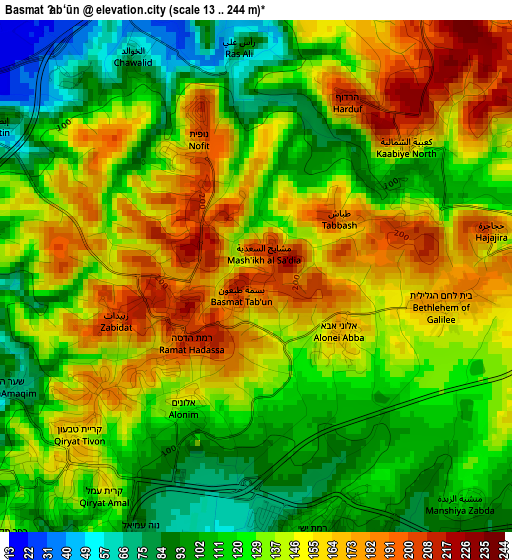
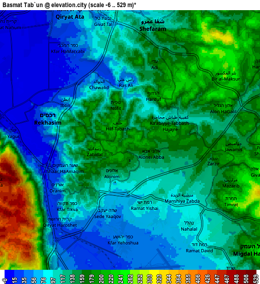
Below is the Elevation map of Basmat Ṭab‘ūn, which displays elevation range with different colors. Scale of the first map is from 13 to 244 m (43 to 801 ft) with average elevation of 135.3 meters (=444 ft) [note 1]
These maps also provides idea of topography and contour of this city, they are displayed at different zoom levels. More info about maps, scale and edge coordinates you can find below images.
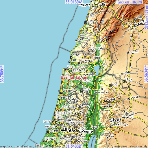
| \ | Map #1 | Map #2 | Topo.Map |
| Scale [m] | 13..244 m | -6..529 m | × |
| Scale [ft] | 43..801 ft | -20..1736 ft | × |
| Average | 135.3 m = 444 ft | 129.6 m = 425 ft | × |
| Width | 8.22 km = 5.1 mi | 16.44 km = 10.2 mi | 263 km = 163.4 mi |
| Height | 8.22 km = 5.1 mi | 16.44 km = 10.2 mi | 263 km = 163.4 mi |
| ↑Max Latitude | 32.775937° | 32.812878° | 33.91394° |
| Latitude at center | 32.73898° | 32.73898° | 32.73898° |
| ↓Min Latitude | 32.702008° | 32.665021° | 31.54832° |
| ← Min Longitude | 35.113215° | 35.069269° | 33.75091° |
| Longitude center | 35.15716° | 35.15716° | 35.15716° |
| →Max Longitude | 35.201105° | 35.245051° | 36.56341° |
Nearby cities:
Cities around Basmat Ṭab‘ūn sort by population:
• Qiryat Ata elevation 46 m
9 km,  333°
333°
• Qiryat Moẕqin 10 m
13.2 km, 325°
• Qiryat Bialik 12 m
11.9 km, 325°
• Daliyat al Karmel 414 m
11.5 km,  244°
244°
• Migdal Ha‘Emeq 227 m
10.4 km,  132°
132°
• Nesher 125 m
11 km,  286°
286°
• Kafr Mandā 176 m
12.5 km,  50°
50°
• Rekhasim 43 m
5.6 km,  281°
281°
• Bīr el Maksūr 255 m
7.3 km, 54°
• Ramat Yishay 98 m
4 km,  161°
161°
• Ibṭīn 93 m
4.7 km,  301°
301°
• Timrat 233 m
7.4 km,  122°
122°
Multilingual:
 En español:
Basmat Ṭab‘ūn elevación 194 m.
 En France:
Basmat Ṭab‘ūn élévation 194 m.
 Auf Deutsch:
Basmat Ṭab‘ūn höhe über dem Meeresspiegel ist 194 m.

Sources and notes:
- [note 1] Map square and city borders are not equal. Map elevation data is calculated only from area inside that square.
- [src 1] Elevation data from geonames database provided with same terms of usage.
- [src 2] The elevation map of Basmat Ṭab‘ūn is generated using elevation data from NASA's 3 arcsec (90m) resolution SRTM data.
- [src 3] Base (background) map © OpenStreetMap contributors tiles are generated by Geofabrik and OpenTopoMap.
Copyright & License:
This Basmat Ṭab‘ūn Elevation Map is licensed under CC BY-SA. You may reuse any part from this page, if you give a proper credit by linking to this URL:
 More info on terms of use page.