Migdal Ha‘Emeq elevation
Migdal Ha‘Emeq (Northern District), Israel elevation is 227 meters and Migdal Ha‘Emeq elevation in feet is 745 ft above sea level [src 1]. Migdal Ha‘Emeq is a populated place (feature code) with elevation that is 16 meters (52 ft) bigger than average city elevation in Israel.
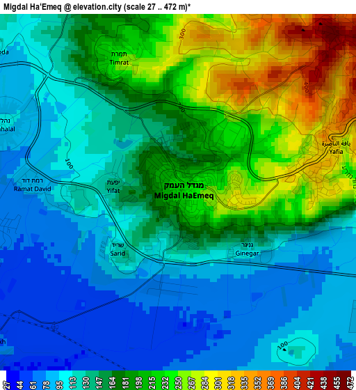
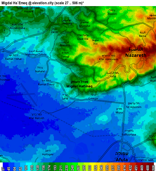
Below is the Elevation map of Migdal Ha‘Emeq, which displays elevation range with different colors. Scale of the first map is from 27 to 472 m (89 to 1549 ft) with average elevation of 159.3 meters (=523 ft) [note 1]
These maps also provides idea of topography and contour of this city, they are displayed at different zoom levels. More info about maps, scale and edge coordinates you can find below images.
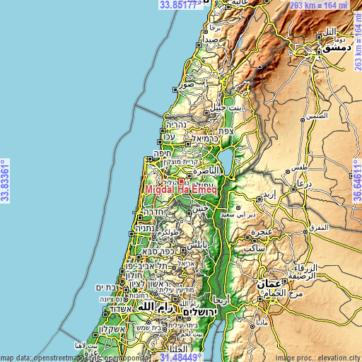
| \ | Map #1 | Map #2 | Topo.Map |
| Scale [m] | 27..472 m | 27..506 m | × |
| Scale [ft] | 89..1549 ft | 89..1660 ft | × |
| Average | 159.3 m = 523 ft | 146 m = 479 ft | × |
| Width | 8.23 km = 5.1 mi | 16.45 km = 10.2 mi | 263.2 km = 163.5 mi |
| Height | 8.23 km = 5.1 mi | 16.45 km = 10.2 mi | 263.2 km = 163.5 mi |
| ↑Max Latitude | 32.712953° | 32.74992° | 33.85177° |
| Latitude at center | 32.67597° | 32.67597° | 32.67597° |
| ↓Min Latitude | 32.638972° | 32.601959° | 31.48449° |
| ← Min Longitude | 35.195915° | 35.151969° | 33.83361° |
| Longitude center | 35.23986° | 35.23986° | 35.23986° |
| →Max Longitude | 35.283805° | 35.327751° | 36.64611° |
Nearby cities:
Cities around Migdal Ha‘Emeq sort by population:
• Nazareth elevation 504 m
6 km,  63°
63°
• Afula 62 m
8.8 km,  148°
148°
• Kafr Kannā 278 m
12.4 km,  50°
50°
• Er Reina 343 m
8.9 km, 53°
• Iksāl 160 m
7.9 km,  85°
85°
• Dabbūrīya 180 m
12.4 km,  81°
81°
• Bīr el Maksūr 255 m
11.4 km,  350°
350°
• Basmat Ṭab‘ūn 194 m
10.4 km,  312°
312°
• Ramat Yishay 98 m
7.2 km,  296°
296°
• Sūlam 120 m
11.8 km,  131°
131°
• Timrat 233 m
3.4 km,  333°
333°
• Nein 234 m
11.4 km,  116°
116°
Multilingual:
 En español:
Migdal Ha‘Emeq elevación 227 m.
 En France:
Migdal Ha‘Emeq élévation 227 m.
 Auf Deutsch:
Migdal Ha‘Emeq höhe über dem Meeresspiegel ist 227 m.

Sources and notes:
- [note 1] Map square and city borders are not equal. Map elevation data is calculated only from area inside that square.
- [src 1] Elevation data from geonames database provided with same terms of usage.
- [src 2] The elevation map of Migdal Ha‘Emeq is generated using elevation data from NASA's 3 arcsec (90m) resolution SRTM data.
- [src 3] Base (background) map © OpenStreetMap contributors tiles are generated by Geofabrik and OpenTopoMap.
Copyright & License:
This Migdal Ha‘Emeq Elevation Map is licensed under CC BY-SA. You may reuse any part from this page, if you give a proper credit by linking to this URL:
 More info on terms of use page.