Kafr Kannā elevation
Kafr Kannā (Northern District), Israel elevation is 278 meters and Kafr Kannā elevation in feet is 912 ft above sea level [src 1]. Kafr Kannā is a populated place (feature code) with elevation that is 67 meters (220 ft) bigger than average city elevation in Israel.
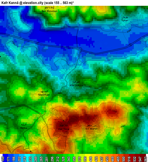
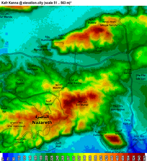
Below is the Elevation map of Kafr Kannā, which displays elevation range with different colors. Scale of the first map is from 155 to 563 m (509 to 1847 ft) with average elevation of 297.2 meters (=975 ft) [note 1]
These maps also provides idea of topography and contour of this city, they are displayed at different zoom levels. More info about maps, scale and edge coordinates you can find below images.
| \ | Map #1 | Map #2 | Topo.Map |
| Scale [m] | 155..563 m | 51..563 m | × |
| Scale [ft] | 509..1847 ft | 167..1847 ft | × |
| Average | 297.2 m = 975 ft | 249.2 m = 818 ft | × |
| Width | 8.22 km = 5.1 mi | 16.44 km = 10.2 mi | 263 km = 163.4 mi |
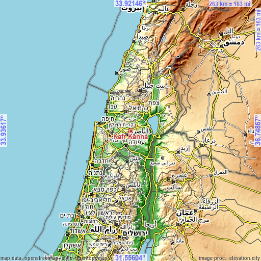
| Height | 8.22 km = 5.1 mi | 16.44 km = 10.2 mi | 263 km = 163.4 mi |
| ↑Max Latitude | 32.783553° | 32.820492° | 33.92146° |
| Latitude at center | 32.7466° | 32.7466° | 32.7466° |
| ↓Min Latitude | 32.709631° | 32.672647° | 31.55604° |
| ← Min Longitude | 35.298475° | 35.254529° | 33.93617° |
| Longitude center | 35.34242° | 35.34242° | 35.34242° |
| →Max Longitude | 35.386365° | 35.430311° | 36.74867° |
Nearby cities:
Cities around Kafr Kannā sort by population:
• Nazareth elevation 504 m
6.6 km,  219°
219°
• Er Reina 343 m
3.6 km, 223°
• Kafr Mandā 176 m
10.5 km,  312°
312°
• Iksāl 160 m
7.4 km,  193°
193°
• Dabbūrīya 180 m
6.6 km,  155°
155°
• Bu‘eina 238 m
7 km,  17°
17°
• Shibli 234 m
7.4 km,  140°
140°
• ‘Eilabun 187 m
11.4 km,  28°
28°
• Kafr Kammā 228 m
9.7 km,  106°
106°
• ‘Uzeir 166 m
5.2 km,  346°
346°
• Kefar Tavor 118 m
9.9 km,  132°
132°
• Rumat Heib 221 m
4.9 km,  315°
315°
Multilingual:
 En español:
Kafr Kannā elevación 278 m.
 En France:
Kafr Kannā élévation 278 m.
 Auf Deutsch:
Kafr Kannā höhe über dem Meeresspiegel ist 278 m.

Sources and notes:
- [note 1] Map square and city borders are not equal. Map elevation data is calculated only from area inside that square.
- [src 1] Elevation data from geonames database provided with same terms of usage.
- [src 2] The elevation map of Kafr Kannā is generated using elevation data from NASA's 3 arcsec (90m) resolution SRTM data.
- [src 3] Base (background) map © OpenStreetMap contributors tiles are generated by Geofabrik and OpenTopoMap.
Copyright & License:
This Kafr Kannā Elevation Map is licensed under CC BY-SA. You may reuse any part from this page, if you give a proper credit by linking to this URL:
 More info on terms of use page.