Tiberias elevation
Tiberias (Northern District), Israel elevation is -140 meters and Tiberias elevation in feet is -459 ft above sea level [src 1]. Tiberias is a populated place (feature code) with elevation that is 351 meters (1152 ft) smaller than average city elevation in Israel.
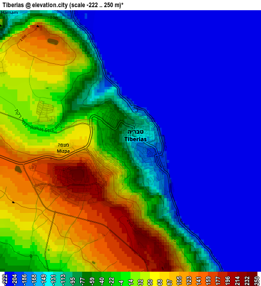
Below is the Elevation map of Tiberias, which displays elevation range with different colors. Scale of the first map is from -222 to 250 m (-728 to 820 ft) with average elevation of -67.4 meters (=-221 ft) [note 1]
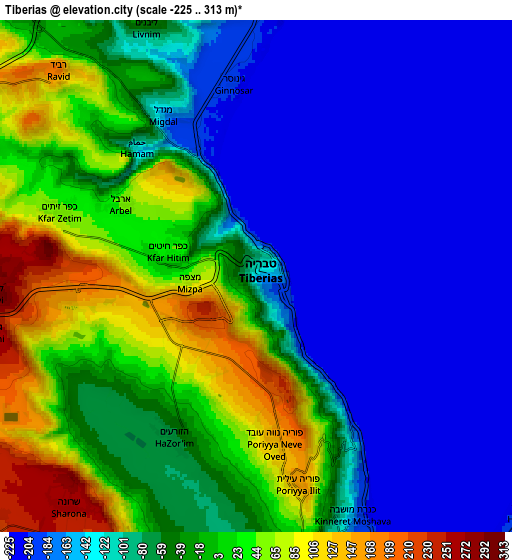
These maps also provides idea of topography and contour of this city, they are displayed at different zoom levels. More info about maps, scale and edge coordinates you can find below images.
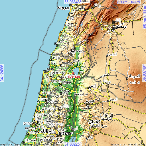
| \ | Map #1 | Map #2 | Topo.Map |
| Scale [m] | -222..250 m | -225..313 m | × |
| Scale [ft] | -728..820 ft | -738..1027 ft | × |
| Average | -67.4 m = -221 ft | -72.5 m = -238 ft | × |
| Width | 8.22 km = 5.1 mi | 16.43 km = 10.2 mi | 262.9 km = 163.4 mi |
| Height | 8.22 km = 5.1 mi | 16.43 km = 10.2 mi | 262.9 km = 163.4 mi |
| ↑Max Latitude | 32.829145° | 32.866064° | 33.96646° |
| Latitude at center | 32.79221° | 32.79221° | 32.79221° |
| ↓Min Latitude | 32.75526° | 32.718295° | 31.60225° |
| ← Min Longitude | 35.487295° | 35.443349° | 34.12499° |
| Longitude center | 35.53124° | 35.53124° | 35.53124° |
| →Max Longitude | 35.575185° | 35.619131° | 36.93749° |
Nearby cities:
Cities around Tiberias sort by population:
• Maghār elevation 292 m
15.9 km,  313°
313°
• Kafr Kannā 278 m
18.4 km,  253°
253°
• Deir Ḥannā 289 m
17.5 km,  296°
296°
• Dabbūrīya 180 m
18.6 km,  233°
233°
• Bu‘eina 238 m
15.6 km,  275°
275°
• Shibli 234 m
16.9 km, 230°
• ‘Eilabun 187 m
13.2 km,  292°
292°
• Kafr Kammā 228 m
11.5 km, 226°
• Yavne’el -18 m
9.9 km,  194°
194°
• Kefar Tavor 118 m
15.6 km,  221°
221°
• Al Buţayḩah -193 m
16 km,  35°
35°
• Fīq 330 m
15.9 km,  95°
95°
Multilingual:
 En español:
Tiberíades elevación -140 m.
 En France:
Tibériade élévation -140 m.
 Auf Deutsch:
Tiberias höhe über dem Meeresspiegel ist -140 m.

Sources and notes:
- [note 1] Map square and city borders are not equal. Map elevation data is calculated only from area inside that square.
- [src 1] Elevation data from geonames database provided with same terms of usage.
- [src 2] The elevation map of Tiberias is generated using elevation data from NASA's 3 arcsec (90m) resolution SRTM data.
- [src 3] Base (background) map © OpenStreetMap contributors tiles are generated by Geofabrik and OpenTopoMap.
Copyright & License:
This Tiberias Elevation Map is licensed under CC BY-SA. You may reuse any part from this page, if you give a proper credit by linking to this URL:
 More info on terms of use page.